
Pinedale is a town in and the county seat of Sublette County, Wyoming, United States. The population was 2,030 at the 2010 census. Pinedale is an important hunting outfitting town and a gateway to the Wind River Mountains. It is also a major gateway to the Jackson Hole area in Wyoming. Additionally, Pinedale is near several large natural gas fields, including the Pinedale Anticline and Jonah Field. Attractions include the Museum of the Mountain Man, Green River Rendezvous Days, White Pine Ski Area, the Pinedale Aquatic Center and the Town Park System along the Pine Creek Corridor in the middle of town. The mayor is Matt Murdock, who was elected in 2018.

The Wind River Range is a mountain range of the Rocky Mountains in western Wyoming in the United States. The range runs roughly NW–SE for approximately 100 mi (160 km). The Continental Divide follows the crest of the range and includes Gannett Peak, which at 13,802 ft (4,207 m), is the highest peak in Wyoming; and also Fremont Peak at 13,750 ft (4,191 m), the third highest peak in Wyoming. There are more than 40 other named peaks in excess of 12,999 ft (3,962 m). With the exception of the Grand Teton in the Teton Range, the next 19 highest peaks in Wyoming after Gannett are also in the Winds.

Gannett Peak is the highest mountain peak in the U.S. state of Wyoming at 13,810 feet (4,210 m). It lies in the Wind River Range within the Bridger Wilderness of the Bridger-Teton National Forest. Straddling the Continental Divide along the boundary between Fremont and Sublette counties, it has the second greatest topographic prominence in the state (7076') after Cloud Peak (7077'), and is the highest ground for 290.36 miles in any direction.

Fremont Peak is the third highest peak in the state of Wyoming, surpassed only by Gannett Peak and Grand Teton, and straddles the boundary between Fremont and Sublette counties in the Wind River Range. It is named for American explorer John C. Fremont who climbed the peak with Charles Preuss and Johnny Janisse from August 13 to August 15, 1842. Kit Carson had been with the climbing party on its first attempt at the peak, but had gone back for supplies the day Fremont and his men reached the summit. Carson is thought by some to have been the first to climb neighboring Jackson Peak. At that time, Fremont Peak was mistakenly thought to be the highest mountain in the Rocky Mountains, although there are actually over 100 higher peaks in the Rocky Mountain range.

The Bridger Wilderness is located in Bridger-Teton National Forest in Wyoming, United States. Originally established in 1931 as a primitive area, 428,169-acre (1,732.74 km2) region was redesignated as a wilderness in 1964 and expanded to the current size in 1984. The wilderness lies on the west side of the Continental Divide in the Wind River Range and contains Gannett Peak; at 13,809 feet (4,209 m) it is the tallest mountain in Wyoming. The wilderness is a part of the Greater Yellowstone Ecosystem.

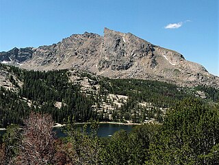
Lizard Head Peak is in the southern Wind River Range in the U.S. state of Wyoming. Situated in Shoshone National Forest, Lizard Head Peak is the northeasternmost peak in the Cirque of the Towers, a popular climbing area. Lizard Head Glacier is just WWN of the peak.

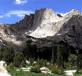
Mount Helen is located in the Wind River Range in the U.S. state of Wyoming. The peak is the fourth highest peak in the range and the fifth tallest in Wyoming. The summit is located in the Bridger Wilderness of Bridger-Teton National Forest, immediately west of the Continental Divide. The eastern flanks of the mountain are covered in snowfields and glaciers, including Helen and Sacagawea Glaciers, all of which are in the Fitzpatrick Wilderness of Shoshone National Forest.
Baby Glacier is in the Bridger Wilderness of Bridger-Teton National Forest, in the U.S. state of Wyoming. The glacier is immediately west of the much larger Mammoth Glacier, both of which are on the west side of the Continental Divide in the northern Wind River Range. The glacier occupies a north facing cirque and flows northward from the slopes of Mount Whitecap. Baby Glacier is in the Bridger Wilderness and is part of the largest grouping of glaciers in the American Rocky Mountains.

Pingora Peak is a prominent granite peak in the U.S. state of Wyoming. The peak is one of the pinnacles that forms the Cirque of the Towers. Pingora Peak is in the Popo Agie Wilderness and part of the Wind River Range within the greater Shoshone National Forest. The Northeast Face route on Pingora Peak is recognized in the historic climbing text Fifty Classic Climbs of North America and considered a classic around the world.

Mount Hooker is located in the Wind River Range in the U.S. state of Wyoming. Mount Hooker was named for Joseph Dalton Hooker, the prominent 19th-century British botanist and explorer. The north and east slopes of Mount Hooker present some of the tallest and steepest vertical cliffs in Wyoming, and the peak is also remote, being more than 20 mi (32 km) from a road. The formidable 1,800-foot (550 m) north face of Mount Hooker was first climbed in 1964 by Yosemite Valley climber Royal Robbins, along with Dick McCracken and Charlie Raymond, who took over three days to scale the cliff face. In 2013, a team free climbed one pitch rated at class 5.14a, grade VI during a multiple-day ascent requiring five other pitches rated above 5.12.

Mitchell Peak is located in the southern Wind River Range in the U.S. state of Wyoming. Mitchell Peak is on the southern side of the Cirque of the Towers, a popular climbing area. Mitchell Peak sits along the Continental Divide, less than 1 mi (1.6 km) northwest of Dog Tooth Peak. The peak was named after Finis Mitchell a respected forester and mountain climber of the Wind River Range. In recognition of his many accomplishments, the U.S. Congress named the peak after Mitchell while he was still living.

War Bonnet Peak is located in the southern Wind River Range in the U.S. state of Wyoming. War Bonnet Peak is on the southern side of the Cirque of the Towers, a popular climbing area, rising steeply above Jackass Pass. War Bonnet Peak sits along the Continental Divide, less than 1 mi (1.6 km) across Jackass Pass from Mitchell Peak.
Pylon Peak is located in the southern Wind River Range in the U.S. state of Wyoming. Pylon Peak is on the west side of the Cirque of the Towers, a popular climbing area, and is .70 mi (1.13 km) northwest of Warrior Peaks. Pylon Peak sits along the Continental Divide.
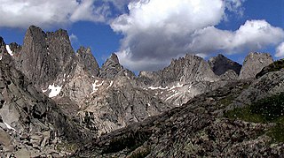
Watch Tower is a mountain located in the southern Wind River Range in the U.S. state of Wyoming. Watch Tower is on the west side of the Cirque of the Towers, a popular climbing area and is just southeast of Block Tower. Watch Tower is immediately east of the Continental Divide.

Block Tower is a mountain located in the southern Wind River Range in the U.S. state of Wyoming. Block Tower is on the west side of the Cirque of the Towers, a popular climbing area and is just northwest of Watch Tower and immediately south of the peak known as Sharks Nose. Block Tower is situated on the Continental Divide.
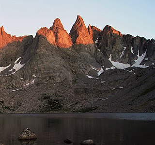
Sharks Nose is a mountain located in the southern Wind River Range in the U.S. state of Wyoming. Sharks Nose is on the west side of the Cirque of the Towers, a popular climbing area. The peak is just north of Block Tower and immediately south of the peak known as Overhanging Tower. Sharks Nose is situated on the Continental Divide.
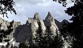
Overhanging Tower is a mountain located in the southern Wind River Range in the U.S. state of Wyoming. Overhanging Tower is on the west side of the Cirque of the Towers, a popular climbing area. The peak is just north of Sharks Nose and south of the peak known as Wolfs Head. Overhanging Tower is situated on the Continental Divide.
Wolfs Head is a mountain located in the southern Wind River Range in the U.S. state of Wyoming. Wolfs Head is on the northwest side of the Cirque of the Towers, a popular climbing area. The peak is just north of Overhanging Tower and connected to Pingora Peak by a narrow arête. The East Ridge route on the Wolf's Head is recognized in the historic climbing text Fifty Classic Climbs of North America and considered a classic climb. Wolfs Head is situated on the Continental Divide.
Schiestler Peak is an 11,624-foot-elevation (3,543 meter) mountain summit located in Sublette County of Wyoming, United States.

Bollinger Peak is a 12,232-foot-elevation (3,728 meter) mountain summit located on the shared border of Sublette County and Fremont County in the state of Wyoming, United States.


