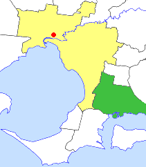
The City of Kingston is a local government area in Victoria, Australia in the south-eastern suburbs of Melbourne, its northern boundary lying approximately 15 km from the Melbourne city centre along the north-eastern shorelines of Port Phillip. It covers an area of 91 km² and has an estimated population of 163,431 people.
The City of Frankston is a local government area (LGA) in Victoria, Australia in the southern suburbs of Melbourne. It has an area of 130 square kilometres, and in June 2018, the City of Frankston recorded a population of 141,845.
The City of Hawthorn was a local government area about 4 kilometres (2.5 mi) east of Melbourne, the state capital of Victoria, Australia, on the southeast bank of the Yarra River. The city covered an area of 9.71 square kilometres (3.75 sq mi), and existed from 1860 until 1994.
The City of Berwick was a local government area about 40 kilometres (25 mi) southeast of Melbourne, the state capital of Victoria, Australia. The city covered an area of 120.43 square kilometres (46.50 sq mi), and existed from 1973 until 1994.
The City of Cranbourne was a local government area about 45 kilometres (28 mi) southeast of Melbourne, the state capital of Victoria, Australia. The city covered an area of 755 square kilometres (291.5 sq mi), and existed from 1860 until 1994. It was notable for being the last local government area to be declared a city prior to the large-scale amalgamations of 1994 – its former designation was the Shire of Cranbourne.

The City of Frankston was a local government area about 40 kilometres (25 mi) south of Melbourne, the state capital of Victoria, Australia. The city covered an area of 70.96 square kilometres (27.4 sq mi) in and around Frankston, and existed from 1860 until 1994.
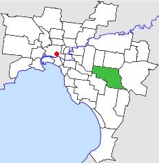
The City of Waverley was a local government area about 20 kilometres (12 mi) east-southeast of Melbourne, the state capital of Victoria, Australia. The city covered an area of 60.86 square kilometres (23.50 sq mi), and existed from 1857 until 1994.
The City of Oakleigh was a local government area about 15 kilometres (9 mi) southeast of Melbourne, the state capital of Victoria, Australia. The city covered an area of 30.30 square kilometres (11.70 sq mi), and existed from 1891 until 1994.
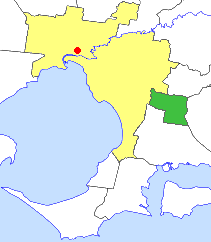
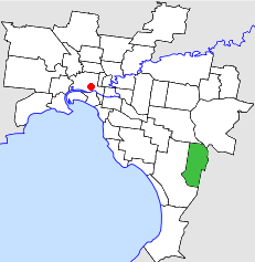
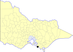
The City of Malvern was a local government area about 9 kilometres (6 mi) southeast of Melbourne, the state capital of Victoria, Australia. The city covered an area of 15.88 square kilometres (6.13 sq mi), and existed from 1856 until 1994, when it was merged with the City of Prahran to create the City of Stonnington.

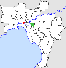
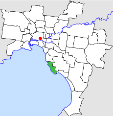
The City of Prahran was a local government area about 5 kilometres (3 mi) southeast of Melbourne, the state capital of Victoria, Australia. The city covered an area of 9.55 square kilometres (3.69 sq mi), and existed from 1855 until 1994, when it was merged with the City of Malvern to create the City of Stonnington.

The City of Ringwood was a local government area about 25 kilometres (16 mi) east of Melbourne, the state capital of Victoria, Australia. The city covered an area of 22.76 square kilometres (8.79 sq mi), and existed from 1924 until 1994.

The City of Croydon was a local government area about 30 kilometres (19 mi) east of Melbourne, the state capital of Victoria, Australia. The city covered an area of 34.32 square kilometres (13.25 sq mi), and existed from 1961 until 1994.

The City of Shepparton was a local government area in the Goulburn Valley region, about 180 kilometres (112 mi) north of Melbourne, the state capital of Victoria, Australia. The city covered an area of 26.71 square kilometres (10.3 sq mi), and existed from 1927 until 1994. It excluded areas such as Mooroopna and Kialla, which are now considered to be suburbs.

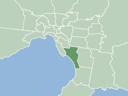
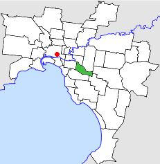
The City of Mordialloc was a local government area about 20 kilometres (12 mi) south of Melbourne, the state capital of Victoria, Australia, on the eastern side of Port Phillip. The city covered an area of 13.57 square kilometres (5.24 sq mi), and existed from 1920 until 1994.
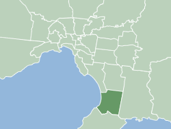
The City of Sandringham was a local government area about 20 kilometres (12 mi) south of Melbourne, the state capital of Victoria, Australia, on the eastern side of Port Phillip. The city covered an area of 14.97 square kilometres (5.78 sq mi), and existed from 1917 until 1994.

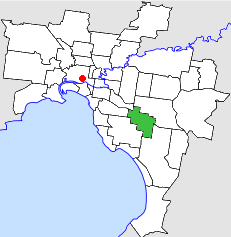
The City of Moorabbin was a local government area about 20 kilometres (12 mi) southeast of Melbourne, the state capital of Victoria, Australia. The city covered an area of 53.13 square kilometres (20.51 sq mi), and existed from 1862 until 1994.

The City of Springvale was a local government area about 30 kilometres (19 mi) southeast of Melbourne, the state capital of Victoria, Australia. The city covered an area of 97.60 square kilometres (37.68 sq mi), and existed from 1857 until 1994.
The City of Dandenong was a local government area about 35 kilometres (22 mi) southeast of Melbourne, the state capital of Victoria, Australia. The city covered an area of 36.26 square kilometres (14.00 sq mi), and existed from 1857 until 1994.
The Borough of Wonthaggi was a local government area about 120 kilometres (75 mi) south-southeast of Melbourne, the state capital of Victoria, Australia. The borough covered an area of 56.99 square kilometres (22.0 sq mi), and existed from 1911 until 1994. Unlike many local government areas, it was constituted under its own Act of Parliament, rather than the Local Government Act.

The City of Moe was a local government area about 130 kilometres (81 mi) east-southeast of Melbourne, the state capital of Victoria, Australia. The city covered an area of 47 square kilometres (18.1 sq mi), and existed from 1955 until 1994.
