Argyll and Bute is one of 32 unitary council areas in Scotland and a lieutenancy area. The current lord-lieutenant for Argyll and Bute is Jane Margaret MacLeod. The administrative centre for the council area is in Lochgilphead at Kilmory Castle, a 19th-century Gothic Revival building and estate. The current council leader is Councillor Jim Lynch.

The Firth of Clyde, is the estuary of the River Clyde, on the west coast of Scotland. The Firth has some of the deepest coastal waters of the British Isles. The Firth is sheltered from the Atlantic Ocean by the Kintyre Peninsula. The Firth lies between West Dunbartonshire in the north, Argyll and Bute in the west and Inverclyde, North Ayrshire and South Ayrshire in the east. The Kilbrannan Sound is a large arm of the Firth, separating the Kintyre Peninsula from the Isle of Arran. The Kyles of Bute separates the Isle of Bute from the Cowal Peninsula. The Sound of Bute separates the islands of Bute and Arran.

Brodick is the main village on the Isle of Arran, in the Firth of Clyde, Scotland. It is halfway along the east coast of the island, in Brodick Bay below Goat Fell, the tallest mountain on Arran. The name is derived from the Norse "breda-vick" meaning "Broad Bay".

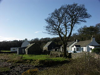
Lochranza is a village located on the Isle of Arran in the Firth of Clyde, Scotland. The population, somewhat in decline, is around 200 people.

The County of Bute, also known as Buteshire, is a historic county and registration county of Scotland. Now replaced by Argyll and Bute for the Isle of Bute, with the Argyll and Bute Council. The Isle of Arran and The Cumbraes are now in North Ayrshire Council area. Since the implementation of the Local Government etc. (Scotland) Act 1994, on the 1 April 1996.

Kintyre is a peninsula in western Scotland, in the southwest of Argyll and Bute. The peninsula stretches about 30 miles, from the Mull of Kintyre in the south to East and West Loch Tarbert in the north. The region immediately north of Kintyre is known as Knapdale.
Knapdale forms a rural district of Argyll and Bute in the Scottish Highlands, adjoining Kintyre to the south, and divided from the rest of Argyll to the north by the Crinan Canal. It includes two parishes, North Knapdale and South Knapdale. The area is bounded by sea to the east and west, whilst the sea loch of West Loch Tarbert almost completely cuts off the area from Kintyre to the south. The name is derived from two Gaelic elements: Cnap meaning hill and Dall meaning field.
Cowal is a rugged peninsula in Argyll and Bute, on the west coast of Scotland. It is connected to the mainland to the north, and is bounded by Loch Fyne to the west, by Loch Long and the Firth of Clyde to the east, and by the Kyles of Bute to the south.

Loch Fyne, is a sea loch off the Firth of Clyde and forms part of the coast of the Cowal Peninsula. Located on the west coast of Argyll and Bute, west of Scotland. It extends 65 kilometres (40 mi) inland from the Sound of Bute, making it the longest of the sea lochs in Scotland. It is connected to the Sound of Jura by the Crinan Canal. Although there is no evidence that grapes have grown there, the title is probably honorific, indicating that the river, Abhainn Fìne, was a well-respected river.

Tarbert is a village in the west of Scotland, in the Argyll and Bute council area. It is built at the head of an inlet of Loch Fyne called East Loch Tarbert, on a narrow isthmus which connects Kintyre to the south with Knapdale to the north and separates East Loch Tarbert from the much longer West Loch Tarbert. Tarbert had a recorded population of 1,338 in the 2001 Census.

Skipness is a village and Quoad sacra parish on the east coast of Kintyre in Scotland, located just over 7 miles (11 km) south of Tarbert and facing the Isle of Arran.

Tayinloan is a village situated on the west coast of the Kintyre peninsula in Argyll and Bute, Scotland. The village has a sub post office, general store and a small hotel, a village hall and a play park. There is a cafe bar situated beside the ferry car park which also offers self-catering or bed and breakfast accommodation. The nearest towns are Campbeltown and Tarbert.
Grogport is a hamlet in Argyll and Bute, Scotland. It lies on the coast of Kintyre, on the Kilbrannan Sound, across from Pirnmill on the Isle of Arran.
National Cycle Route 78 runs from Campbeltown to Inverness. It was officially launched as the Caledonia Way in 2016 as part of the wider redevelopment of Scotland's cycle network. It runs from the Kintyre peninsula to the Great Glen and the route varies from on road to traffic-free forest trails and canal paths.

The A841 road is the only A-road on the Isle of Arran and forms the island's primary transport route. Until 2009, the road circumnavigated the island around a 55-mile route. However, in 2009 the section between Dippen, just south of Whiting Bay and Lochranza via Blackwaterfoot was downgraded, leaving a truncated A841 to run between Whiting Bay and Lochranza via Brodick. At only one point does it venture inland, and this is to climb the 600-foot (180-metre) pass at Boguillie between Creag Ghlas Laggan and Caisteal Abhail in the north east of the island.

West Loch Tarbert is a long, narrow sea loch on the western side of the Kintyre Peninsula, in Argyll and Bute, west of Scotland.

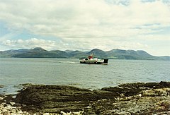
MV Loch Tarbert is a Caledonian Maritime Assets Limited ro-ro car ferry, built in 1992 and currently operated by Caledonian MacBrayne. She has spent most of her career on the seasonal Claonaig – Lochranza crossing.

MV Rhum is a car ferry built for Caledonian MacBrayne in 1974. Until 1987, she operated the seasonal Lochranza crossing to Arran. Since 1998, she has been one of the Arranmore ferries in County Donegal.
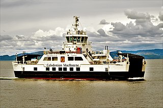
MV Catriona is a diesel electric hybrid passenger and vehicle roll-on, roll-off ferry built for Caledonian MacBrayne for the Claonaig–Lochranza crossing. She is the third hybrid ferry commissioned and owned by Caledonian Maritime Assets, one of three such ferries in the world to incorporate a low-carbon hybrid system of diesel electric and lithium-ion battery power. The ferries are sea-going and are nearly 46 metres (150 ft) long, accommodating 150 passengers, 23 cars or two HGVs.

The Kintyre Way is a waymarked footpath through the Kintyre Peninsula in Argyll and Bute, west of Scotland. It runs between Machrihanish near the southern end of the peninsula's west coast, and Tarbert at the northern end of Kintyre where the peninsula is linked to Knapdale, via Campbeltown. The way is 161 kilometres (100 mi) long, and is fully waymarked. Additionally there are distance markers at 1 mile (1.6 km) intervals along the route. The route is primarily intended for walkers, but most sections can also be cycled.