Clearfield Township, Butler County, Pennsylvania

Last updated

Clearfield Township,
Butler County,
Pennsylvania
Clearfield Township Butler County Pennsylvania.jpg
U.S. Route 422 in the wooded hills of Clearfield Township
Map of Clearfield Township, Butler County, Pennsylvania Highlighted.png
Map of Butler County, Pennsylvania, highlighting Clearfield Township
Map of Pennsylvania highlighting Butler County.svg
Map of Butler County, Pennsylvania
Country United States
State Pennsylvania
County Butler
Settled1798
Incorporated1804
Area
[1]
  Total23.64 sq mi (61.23 km2)
  Land23.64 sq mi (61.23 km2)
  Water0.00 sq mi (0.01 km2)
Population
 (2020) [2]
  Total2,430 Decrease2.svg
  Estimate 
(2022) [2]
2,379
  Density109.01/sq mi (42.09/km2)
Time zone UTC-5 (Eastern (EST))
  Summer (DST) UTC-4 (EDT)
FIPS code42-019-14048

Clearfield Township is a township in Butler County, Pennsylvania, United States. The population was 2,430 at the 2020 census. [2]

Contents

Geography

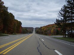
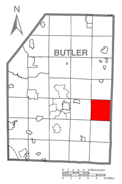
Clearfield Township is located in eastern Butler County, along the Armstrong County border. It contains the unincorporated communities of Coyleville and Fenelton. U.S. Route 422 passes through the township, leading east to Kittanning and west to Butler.

According to the United States Census Bureau, the township has a total area of 23.6 square miles (61.2 km2), all land. [3]

Demographics

Historical population
CensusPop.Note
2010 2,645
2020 2,430−8.1%
2022 (est.)2,379 [2] −2.1%
U.S. Decennial Census [4]

As of the 2000 census, [5] there were 2,705 people, 917 households, and 697 families residing in the township. The population density was 115.8 inhabitants per square mile (44.7/km2). There were 958 housing units at an average density of 41.0 per square mile (15.8/km2). The racial makeup of the township was 98.82% White, 0.22% African American, 0.18% Native American, 0.07% Asian, 0.18% from other races, and 0.52% from two or more races. Hispanic or Latino of any race were 0.52% of the population.

There were 917 households, out of which 37.0% had children under the age of 18 living with them, 62.7% were married couples living together, 8.6% had a female householder with no husband present, and 23.9% were non-families. 19.8% of all households were made up of individuals, and 5.9% had someone living alone who was 65 years of age or older. The average household size was 2.77 and the average family size was 3.15.

In the township the population was spread out, with 25.2% under the age of 18, 7.7% from 18 to 24, 31.1% from 25 to 44, 23.4% from 45 to 64, and 12.5% who were 65 years of age or older. The median age was 38 years. For every 100 females, there were 98.9 males. For every 100 females age 18 and over, there were 99.4 males.

The median income for a household in the township was $35,208, and the median income for a family was $42,375. Males had a median income of $30,682 versus $20,714 for females. The per capita income for the township was $14,952. About 5.9% of families and 10.8% of the population were below the poverty line, including 9.5% of those under age 18 and 11.9% of those age 65 or over.

Education

It is in the Butler Area School District. [6] Butler Area Intermediate High School and Butler Area Senior High School are the district's comprehensive secondary schools.

The district formerly operated Clearfield Township Elementary School, [7] which closed in 2015. [8]

Related Research Articles

<span class="mw-page-title-main">Troy Township, Bradford County, Pennsylvania</span> Township in Pennsylvania, United States

Troy Township is a township in Bradford County, Pennsylvania. It is part of Northeastern Pennsylvania. The population was 1,645 at the 2010 census. The town's children are assigned to attend the Troy Area School District.

<span class="mw-page-title-main">Buffalo Township, Butler County, Pennsylvania</span> Township in Pennsylvania, United States

Buffalo Township is a township in Butler County, Pennsylvania, United States. The population was 7,896 at the 2020 census.

<span class="mw-page-title-main">Center Township, Butler County, Pennsylvania</span> Township in Pennsylvania, United States

Center Township is a township in Butler County, Pennsylvania, United States. The population was 7,900 at the 2020 census.

<span class="mw-page-title-main">Donegal Township, Butler County, Pennsylvania</span> Township in Pennsylvania, United States

Donegal Township is a township in Butler County, Pennsylvania, United States. The population was 1,821 at the 2020 census.

<span class="mw-page-title-main">Fairview Township, Butler County, Pennsylvania</span> Township in Pennsylvania, United States

Fairview Township is a township in Butler County, Pennsylvania, United States. The population was 1,942 at the 2020 census.

<span class="mw-page-title-main">Middlesex Township, Butler County, Pennsylvania</span> Township in Pennsylvania, United States

Middlesex Township is a township in Butler County, Pennsylvania, United States. The population was 6,826 at the 2020 census.

<span class="mw-page-title-main">Oakland Township, Butler County, Pennsylvania</span> Township in Pennsylvania, United States

Oakland Township is a township that is located in Butler County, Pennsylvania, United States. The population was 2,772 at the time of the 2020 census.

<span class="mw-page-title-main">Parker Township, Pennsylvania</span> Township in Pennsylvania, United States

Parker Township is a township that is located in Butler County, Pennsylvania, United States. The population was 574 at the time of the 2020 census.

<span class="mw-page-title-main">Summit Township, Butler County, Pennsylvania</span> Township in Pennsylvania, United States

Summit Township is a township that is located in Butler County, Pennsylvania, United States. The population was 4,503 at the time of the 2020 census.

<span class="mw-page-title-main">Bloom Township, Pennsylvania</span> Township in Pennsylvania, United States

Bloom Township is a township in Clearfield County, Pennsylvania, United States. The population was 381 at the 2020 census.

<span class="mw-page-title-main">Bradford Township, Clearfield County, Pennsylvania</span> Township in Pennsylvania, United States

Bradford Township is a township in Clearfield County, Pennsylvania, United States. The population was 2,836 at the 2020 census.

<span class="mw-page-title-main">Brady Township, Clearfield County, Pennsylvania</span> Township in Pennsylvania, United States

Brady Township is a township in Clearfield County, Pennsylvania, United States. The population was 1,941 at the 2020 census.

<span class="mw-page-title-main">Decatur Township, Clearfield County, Pennsylvania</span> Township in Pennsylvania, United States

Decatur Township is a township in Clearfield County, Pennsylvania, United States. The population was 4,549 at the 2020 census, an increase over the figure tabulated in the 2010 census in which the population was 2,548. The township is named after war hero Stephen Decatur, Jr.

<span class="mw-page-title-main">Lawrence Township, Clearfield County, Pennsylvania</span> Township in Pennsylvania, United States

Lawrence Township is a township in Clearfield County, Pennsylvania, United States. The population was 7,503 at the 2020 census. Lawrence Township borders the townships of Boggs, Bradford, Goshen, Huston, Knox, Pike and Pine in Clearfield County, as well as Benezette and Jay Townships in Elk County to the north. Lawrence Township borders the borough of Clearfield as well.

<span class="mw-page-title-main">Woodward Township, Clearfield County, Pennsylvania</span> Township in Pennsylvania, United States

Woodward Township is a township in Clearfield County, Pennsylvania, United States. The population was 4,108 at the 2020 census.

<span class="mw-page-title-main">Nicholson Township, Fayette County, Pennsylvania</span> Township in Pennsylvania, United States

Nicholson Township is a township in Fayette County, Pennsylvania, United States. The population was 1,730 at the 2020 census, a decline from the figure of 1,805 tabulated in 2010. The Albert Gallatin Area School District serves the township. New Geneva, Martin, Gallatin, Old Frame, Bowood, Woodside, and Grays Landing are communities in the township.

<span class="mw-page-title-main">Perry Township, Fayette County, Pennsylvania</span> Township in Pennsylvania, United States

Perry Township is a township in Fayette County, Pennsylvania, United States. The population was 2,339 at the 2020 census, a decline from the figure of 2,552 tabulated in 2010. The Frazier School District serves the township.

<span class="mw-page-title-main">Whiteley Township, Pennsylvania</span> Township in Pennsylvania, United States

Whiteley Township is a township that is located in Greene County, Pennsylvania, United States. The population was 569 at the time of the 2020 census, which was a decreased from the total of 649 that was documented during the 2010 census.

<span class="mw-page-title-main">Cherrytree Township, Pennsylvania</span> Township in Pennsylvania, United States

Cherrytree Township is a township in Venango County, Pennsylvania, United States. The population was 1,306 at the 2020 census, a decrease from 1,973 in 2010. It is part of Titusville.

<span class="mw-page-title-main">Heidelberg Township, York County, Pennsylvania</span> Township in Pennsylvania, United States

Heidelberg Township is a township in York County, Pennsylvania, United States. The township was erected in 1750 and encompassed the land grant known as Digges' Choice, a warrant granted to John Digges in 1727 by the colonial-era Province of Maryland, prior to the time the Mason-Dixon line fixed the final boundary between Maryland and Pennsylvania. The population of Heidelberg Township was 3,027 at the 2020 census.

References

  1. "2016 U.S. Gazetteer Files". United States Census Bureau. Retrieved August 13, 2017.
  2. 1 2 3 4 Bureau, US Census. "City and Town Population Totals: 2020-2022". Census.gov. US Census Bureau. Retrieved June 19, 2023.
  3. "Geographic Identifiers: 2010 Demographic Profile Data (G001): Clearfield township, Butler County, Pennsylvania". U.S. Census Bureau, American Factfinder. Archived from the original on February 12, 2020. Retrieved March 27, 2014.
  4. "Census of Population and Housing". Census.gov. Retrieved June 4, 2016.
  5. "U.S. Census website". United States Census Bureau . Retrieved January 31, 2008.
  6. "2020 CENSUS - SCHOOL DISTRICT REFERENCE MAP: Butler County, PA" (PDF). U.S. Census Bureau . Retrieved July 15, 2024. - Text list
  7. "Butler Area Schools". Butler Area School District. Archived from the original on April 13, 1997. Retrieved July 15, 2024.
  8. "Residents Upset With Butler District's Decision To Close Schools". CBS News. KDKA-TV. May 7, 2015. Retrieved July 15, 2024.

40°50′00″N79°45′59″W / 40.83333°N 79.76639°W / 40.83333; -79.76639