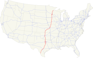
Interstate 35 (I-35) is a major Interstate Highway in the central United States. As with most interstates that end in a five, it is a major cross-country, north-south route. It stretches from Laredo, Texas, near the Mexican-American border to Duluth, Minnesota, at Minnesota Highway 61 and 26th Avenue East. The highway splits into Interstate 35E and Interstate 35W in two separate places, the Dallas–Fort Worth metroplex in Texas and at the Minnesota twin cities of Minneapolis–Saint Paul.

Carter County is a county in the U.S. state of Oklahoma. As of the 2010 census, the population was 47,557. Its county seat is Ardmore. The county was named for Captain Ben W. Carter, a Cherokee who lived among the Chickasaw.
U.S. Route 77 is a major north–south United States Numbered Highway which extends for 1,305 miles (2,100 km) in the central United States. As of 2005, Its southern terminus is in Brownsville, Texas, at Veteran's International Bridge on the Mexican border, where it connects with both Mexican Federal Highway 101 and Mexican Federal Highway 180, and the highway's northern terminus is in Sioux City, Iowa, at an interchange with Interstate 29 (I-29).

U.S. Route 377 (US 377) is a 478-mile-long (769 km) north–south United States highway. Originally formed as a short spur to connect Denton, Texas with Fort Worth, Texas, it has since been extended to Oklahoma and Mexico.

U.S. Route 271 is a north–south United States highway. Never a long highway, it went from bi-state route to a tri-state route. Its southern terminus is in Tyler, Texas, at an intersection with State Highway 31 and SH 155. The highway's northern terminus is in Fort Smith, Arkansas, at an intersection with Business U.S. Route 71 and Highway 255. It enters Arkansas from Oklahoma as a controlled-access highway, but the highway continues as Interstate 540 when US 271 exits toward downtown after one-half mile (800 m) in Arkansas.

Cobalt blue is a blue pigment made by sintering cobalt(II) oxide with alumina at 1200 °C. Chemically, cobalt blue pigment is cobalt(II) oxide-aluminium oxide, or cobalt(II) aluminate, CoAl2O4. Cobalt blue is lighter and less intense than the (iron-cyanide based) pigment Prussian blue. It is extremely stable and historically, has been used as a coloring agent in ceramics (especially Chinese porcelain), jewelry, and paint. Transparent glasses are tinted with the silica-based cobalt pigment smalt.

The Chevrolet Cobalt is a compact car introduced by Chevrolet in 2004 for the 2005 model year. The Cobalt replaced both the Cavalier and the Toyota-based Geo/Chevrolet Prizm as Chevrolet's compact car. The Cobalt was available as both a coupe and sedan, as well as a sport compact version dubbed the Cobalt SS. Like the Chevrolet HHR and the Saturn ION, it was based on the GM Delta platform.

Cobalt(II) chloride is an inorganic compound of cobalt and chlorine, with the formula CoCl
2. It is a sky blue crystalline solid.

Cobalt-60 (60Co), is a synthetic radioactive isotope of cobalt with a half-life of 5.2713 years. It is produced artificially in nuclear reactors. Deliberate industrial production depends on neutron activation of bulk samples of the monoisotopic and mononuclidic cobalt isotope 59
Co
. Measurable quantities are also produced as a by-product of typical nuclear power plant operation and may be detected externally when leaks occur. In the latter case the incidentally produced 60
Co
is largely the result of multiple stages of neutron activation of iron isotopes in the reactor's steel structures via the creation of its 59
Co
precursor. The simplest case of the latter would result from the activation of 58
Fe
. 60
Co
decays by beta decay to the stable isotope nickel-60. The activated nickel nucleus emits two gamma rays with energies of 1.17 and 1.33 MeV, hence the overall nuclear equation of the reaction is 59
27Co
+ n → 60
27Co
→ 60
28Ni
+ e− +
ν
e + gamma rays.

Cobalt(II) oxide or cobalt monoxide is an inorganic compound that appears as olive-green to red crystals, or as a greyish or black powder. It is used extensively in the ceramics industry as an additive to create blue colored glazes and enamels as well as in the chemical industry for producing cobalt(II) salts.

Cobalt Man is a fictional supervillain appearing in American comic books published by Marvel Comics.
Interstate 40 (I-40) is an Interstate Highway in Oklahoma that runs 331 miles (533 km) across the state from Texas to Arkansas. West of Oklahoma City, it parallels and replaces the old Route 66, and east of Oklahoma City, it parallels US-62, 266, and 64.
Interstate 44 runs diagonally through the U.S. state of Oklahoma, spanning from the Texas state line near Wichita Falls to the Missouri border near Joplin. It connects three of Oklahoma's largest cities, Oklahoma City, Tulsa, and Lawton. Most of I-44 in Oklahoma is a toll road. In southwestern Oklahoma, I-44 is the H.E. Bailey Turnpike and follows a north–south direction. From Oklahoma City to Tulsa, I-44 follows the Turner Turnpike. As I-44 leaves Tulsa it becomes the Will Rogers Turnpike to the Missouri border. In the Lawton, Oklahoma City, and Tulsa metro areas, I-44 is toll-free.
U.S. Highway 59 (US-59) heads along the eastern portion of the state of Oklahoma. US-59's 216.47-mile (348.37 km) route through Oklahoma takes it through the mountainous terrain of the eastern Oklahoma Ouachitas and Ozarks. US-59 serves several lakes and towns through Oklahoma's Green Country, including Grand Lake, a major recreation center. The route enters the state from Arkansas near Fogel, Arkansas, and ends at the Kansas state line south of Chetopa, Kansas.
U.S. Route 60 (US-60) is a transcontinental U.S. highway extending from near Brenda, Arizona to Virginia Beach, Virginia on the Atlantic Ocean. Along the way, 352.39 miles (567.12 km) of the route lies within the state of Oklahoma. The highway crosses into the state from Texas west of Arnett and serves many towns and cities in the northern part of the state, including Arnett, Seiling, Fairview, Enid, Ponca City, Pawhuska, Bartlesville, and Vinita. US-60 exits Oklahoma near Seneca, Missouri. In Oklahoma, US-60 has three business routes, serving Tonkawa, Ponca City, and Seneca. The first 60.2 miles (96.9 km) of the route, from the Texas line to Seiling, is also designated as State Highway 51 (SH-51).
U.S. Route 412 is a U.S. highway in the south-central portion of the United States, connecting Springer, New Mexico to Columbia, Tennessee. A 504.11-mile (811.29 km) section of the highway crosses the state of Oklahoma, traversing the state from west to east. Entering the state southwest of Boise City, US-412 runs the length of the Oklahoma Panhandle and serves the northern portion of the state's main body, before leaving the state at West Siloam Springs. Along the way, the route serves many notable cities and towns, including Boise City, Guymon, Woodward, Enid, and the state's second-largest city, Tulsa.
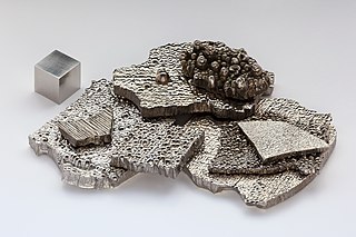
Cobalt is a chemical element with the symbol Co and atomic number 27. Like nickel, cobalt is found in the Earth's crust only in chemically combined form, save for small deposits found in alloys of natural meteoric iron. The free element, produced by reductive smelting, is a hard, lustrous, silver-gray metal.
U.S. Route 64 (US-64) is a U.S. highway running from the Four Corners area to the Outer Banks of North Carolina. Between these two points, the highway passes through the entire width of Oklahoma; a total of 591.17 miles (951.40 km) of US-64 lies in the state of Oklahoma. US-64 enters the state from New Mexico, crossing the line between the two states between Clayton, New Mexico, and Boise City in Cimarron County. The route runs the full length of the Oklahoma Panhandle, then serves the northernmost tier of counties in the main body of the state before dipping southeastward to Tulsa, the state's second-largest city. From Tulsa, the highway continues southeast, leaving Oklahoma just west of Fort Smith, Arkansas. In addition to Tulsa, US-64 serves fifteen Oklahoma counties and the cities of Guymon, Woodward, Enid, and Muskogee.


