Ratliff City, Oklahoma

Last updated

Ratliff City, Oklahoma
OKMap-doton-RatliffCity.PNG
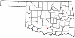
Location of Ratliff City, Oklahoma
Coordinates: 34°26′57″N97°30′56″W / 34.44917°N 97.51556°W / 34.44917; -97.51556
Country United States
State Oklahoma
County Carter
Area
[1]
  Total1.13 sq mi (2.92 km2)
  Land1.12 sq mi (2.91 km2)
  Water0.01 sq mi (0.01 km2)
Elevation
[2]
1,070 ft (330 m)
Population
 (2020)
  Total64
  Density57.04/sq mi (22.02/km2)
Time zone UTC-6 (Central (CST))
  Summer (DST) UTC-5 (CDT)
ZIP code
73481
Area code 580
FIPS code 40-61900 [3]
GNIS feature ID2412530 [2]

Ratliff City is a town in Carter County, Oklahoma, United States. The population was 120 at the 2010 census. [4] Ratliff City was named for Ollie Ratliff, owner of a local garage. It is part of the Ardmore, Oklahoma Micropolitan Statistical Area.

Contents

History

The post office was opened on January 1, 1953, when the town was incorporated.

Geography

Ratliff City is located in northwestern Carter County at the junction of State Highways 7 and 76. Highway 7 leads east 24 miles (39 km) to Davis and west 27 miles (43 km) to Duncan, while Highway 76 leads north 12 miles (19 km) to Foster and south 15 miles (24 km) to Healdton.

According to the United States Census Bureau, Ratliff City has a total area of 1.1 square miles (2.9 km2), all land. [4]

Demographics

Historical population
CensusPop.Note
1970 250
1980 35040.0%
1990 157−55.1%
2000 131−16.6%
2010 120−8.4%
2020 64−46.7%
U.S. Decennial Census [5]

As of the census [3] of 2000, there were 131 people, 53 households, and 41 families residing in the town. The population density was 116.6 inhabitants per square mile (45.0/km2). There were 70 housing units at an average density of 62.3 per square mile (24.1/km2). The racial makeup of the town was 87.79% White, 1.53% African American, 5.34% Native American, and 5.34% from two or more races.

There were 53 households, out of which 32.1% had children under the age of 18 living with them, 62.3% were married couples living together, 13.2% had a female householder with no husband present, and 20.8% were non-families. 17.0% of all households were made up of individuals, and 13.2% had someone living alone who was 65 years of age or older. The average household size was 2.47 and the average family size was 2.74.

In the town, the population was spread out, with 25.2% under the age of 18, 3.8% from 18 to 24, 26.7% from 25 to 44, 27.5% from 45 to 64, and 16.8% who were 65 years of age or older. The median age was 41 years. For every 100 females, there were 79.5 males. For every 100 females age 18 and over, there were 78.2 males.

The median income for a household in the town was $23,125, and the median income for a family was $27,917. Males had a median income of $37,083 versus $11,250 for females. The per capita income for the town was $11,080. There were 20.0% of families and 17.5% of the population living below the poverty line, including 27.6% of under eighteens and 25.0% of those over 64.

Related Research Articles

Branch is a city in Franklin County, Arkansas, United States. It is part of the Fort Smith, Arkansas-Oklahoma Metropolitan Statistical Area. The population was 367 at the 2010 census.

<span class="mw-page-title-main">Hitchcock, Oklahoma</span> Town in Oklahoma, United States

Hitchcock is a town in Blaine County, Oklahoma, United States. The population was 121 at the 2010 census.

<span class="mw-page-title-main">Okeene, Oklahoma</span> Town in Oklahoma, United States

Okeene is a town in Blaine County, Oklahoma, United States. The population was 1,204 at the 2010 census. The name was created by combining the last letters of Cherokee and Cheyenne.

<span class="mw-page-title-main">Springer, Oklahoma</span> Town in Oklahoma, United States

Springer is a town in Carter County, Oklahoma, United States. The population was 700 at the 2010 census. It is part of the Ardmore, Oklahoma Micropolitan Statistical Area.

<span class="mw-page-title-main">Wilson, Oklahoma</span> Town in Oklahoma, United States

Wilson is a town in Carter County, Oklahoma, United States. The population was 1,724 at the 2010 census. It is part of the Ardmore, Oklahoma Micropolitan Statistical Area. It is home to one of the oldest Assemblies of God churches in Oklahoma, the Wilson Assembly of God Church.

<span class="mw-page-title-main">Butler, Oklahoma</span> Town in Oklahoma, United States

Butler is a town in Custer County, Oklahoma, United States. The population was 287 at the 2010 census.

<span class="mw-page-title-main">Covington, Oklahoma</span> Town in Oklahoma, United States

Covington is a town in Garfield County, Oklahoma, United States. The population was 477 at the 2020 census.

<span class="mw-page-title-main">Douglas, Oklahoma</span> Town in Oklahoma, United States

Douglas is a town in Garfield County, Oklahoma, United States. The population was 32 at the 2010 census.

<span class="mw-page-title-main">Garber, Oklahoma</span> City in Oklahoma, United States

Garber is a city in Garfield County, Oklahoma, United States. The population was 822 at the 2010 census. The city is named after Martin Garber, father of Milton C. Garber, former U.S. congressman, Enid mayor, newspaper editor, and judge. The land was previously part of the Cherokee Outlet, until the U.S. government declared it open to non-Indian settlement in 1893.

<span class="mw-page-title-main">North Enid, Oklahoma</span> Town in Oklahoma, United States

North Enid is a town in Garfield County, Oklahoma, United States. The population was 860 at the 2010 census. The town is served by the Chisholm school district. North Enid was the original railroad town site in the Enid–Pond Creek Railroad War.

<span class="mw-page-title-main">Maysville, Oklahoma</span> Town in Oklahoma, United States

Maysville is a town in Garvin and McClain counties, Oklahoma, United States. The population was 1,232 at the 2010 census, down from 1,313 in 2000.

<span class="mw-page-title-main">Granite, Oklahoma</span> Town in Oklahoma, United States

Granite is a town in Greer County, Oklahoma, United States. The population was 1,628 at the 2020 census.

<span class="mw-page-title-main">Ravia, Oklahoma</span> Town in Oklahoma, United States

Ravia is a town in Johnston County, Oklahoma, United States. The population was 528 at the 2010 census, up from 459 in 2000.

<span class="mw-page-title-main">Warwick, Oklahoma</span> Town in Oklahoma, United States

Warwick is a town in Lincoln County, Oklahoma, United States. The population was 184 at the 2020 census, up from 148 in 2010.

<span class="mw-page-title-main">Luther, Oklahoma</span> Town in Oklahoma, United States

Luther is a town in Oklahoma County, Oklahoma, United States, and a part of the Oklahoma City Metropolitan Area. The population was 1,221 at the 2010 census. Sperling Best Places lists the population of 4073 for the 73054 Luther zip code, which includes the town and immediate surrounding area of rural residents.

<span class="mw-page-title-main">North Miami, Oklahoma</span> Town in Oklahoma, United States

North Miami is a town in Ottawa County, Oklahoma, United States. The population was 290 at the 2020 census. The town is primarily a bedroom community for several larger towns in the county.

St. Louis is a town in Pottawatomie County, Oklahoma, United States. The population was 158 at the 2010 census, a 23.3 percent decline from the figure of 206 in 2000.

<span class="mw-page-title-main">Foyil, Oklahoma</span> Town in Oklahoma, United States

Foyil is a town in Rogers County, Oklahoma, United States. It was named for Alfred Foyil, a local landowner and the first postmaster of the town. The population was 344 at the 2010 census, a 47.0 percent increase over the figure of 234 recorded in 2000.

<span class="mw-page-title-main">Dill City, Oklahoma</span> Town in Oklahoma, United States

Dill City is a town in Washita County, Oklahoma, United States. The population was 562 at the 2010 census.

<span class="mw-page-title-main">Fair Oaks, Oklahoma</span> Town in Oklahoma, United States

Fair Oaks is a town in Rogers and Wagoner counties in the U.S. state of Oklahoma. The population was 103 at the 2010 census, a 15.6 percent decline from the figure of 122 recorded in 2000. It is a suburb of Tulsa.

References

  1. "ArcGIS REST Services Directory". United States Census Bureau. Retrieved September 20, 2022.
  2. 1 2 U.S. Geological Survey Geographic Names Information System: Ratliff City, Oklahoma
  3. 1 2 "U.S. Census website". United States Census Bureau . Retrieved January 31, 2008.
  4. 1 2 "Geographic Identifiers: 2010 Demographic Profile Data (G001): Ratliff City town, Oklahoma". U.S. Census Bureau, American Factfinder. Archived from the original on February 11, 2015. Retrieved February 10, 2015.
  5. "Census of Population and Housing". Census.gov. Retrieved June 4, 2015.

Further reading