
The Eastern Cape is one of the nine provinces of South Africa. Its capital is Bhisho, but its two largest cities are East London and Gqeberha. Due to its climate and nineteenth century towns, it is a common location for tourists. It is also known for being home to many anti-apartheid activists, the most famous being Nelson Mandela hailing from the province.

Uitenhage, officially renamed Kariega, is a South African town in the Eastern Cape Province. It is well known for the Volkswagen factory located there, which is the biggest car factory on the African continent. Along with the city of Port Elizabeth and the small town of Despatch, it forms the Nelson Mandela Bay Metropolitan Municipality.

Albany, South Africa was a district in the Eastern Cape, South Africa. Grahamstown was traditionally the administrative capital, cultural centre and largest town of the Albany district.

The R72 is a provincial route in Eastern Cape, South Africa that connects the N2 north-east of Gqeberha with East London via Port Alfred. It provides an alternative to the N2 for travel between Gqeberha and East London.

The R75 is a provincial route in Eastern Cape, South Africa that connects Graaff-Reinet with Gqeberha via Despatch, Kariega and Jansenville.

The R102 is a Regional Route in South Africa. It is the route designation for all old sections of the N2, thus it is a discontinuous road that resumes in areas where a new N2 has been constructed.

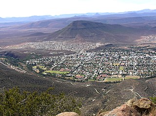
Makhanda, also known as Grahamstown, is a town of about 140,000 people in the Eastern Cape province of South Africa. It is situated about 110 kilometres (70 mi) northeast of Gqeberha and 130 kilometres (80 mi) southwest of East London. It is the largest town in the Makana Local Municipality, and the seat of the municipal council. It also hosts Rhodes University, the Eastern Cape Division of the High Court, the South African Library for the Blind (SALB), a diocese of the Anglican Church of Southern Africa, and 6 South African Infantry Battalion. Furthermore, located approximately 3 km south-east of the town lies the world renowned Waterloo Farm, the only estuarine fossil site in the world from 360 million years ago with exceptional soft-tissue preservation.

Gqeberha, previously named Port Elizabeth, and colloquially referred to as P.E., is a major seaport and the most populous city in the Eastern Cape province of South Africa. It is the seat of the Nelson Mandela Bay Metropolitan Municipality, South Africa's second-smallest metropolitan municipality by area. It is the sixth-most populous city in South Africa and is the cultural, economic and financial hub of the Eastern Cape.

The N2 is a national route in South Africa that runs from Cape Town through George, Gqeberha, East London, Mthatha, Port Shepstone and Durban to Ermelo. It is the main highway along the Indian Ocean coast of the country. Its current length of 2,255 kilometres (1,401 mi) makes it the longest numbered route in South Africa.

Qonce,, is a town in the Eastern Cape province of South Africa along the banks of the Buffalo River. The town is about 60 kilometres (37 mi) northwest of the Indian Ocean port of East London. It has a population of around 35,000 inhabitants and forms part of the Buffalo City Metropolitan Municipality.
The Sarah Baartman District Municipality, formerly the Cacadu District Municipality, is situated in the western part of the Eastern Cape province of South Africa, covering an area of 58,242 square kilometres. The area of the district municipality includes seven local municipalities. The seat is the city of Gqeberha, although Gqeberha is not itself in the district. As of 2011, the languages most spoken among the 388,201 inhabitants were isiXhosa and Afrikaans. The district code is DC10.

The Gariep Dam is located in South Africa, near the town of Norvalspont, bordering the Free State and Eastern Cape provinces. Its primary purpose is for irrigation, domestic and industrial use as well as for power generation.
The !Khukaǁgamma or Sundaysriver is a river in the Eastern Cape Province of South Africa. It is said to be the fastest flowing river in the country. The Inqua Khoi people, who historically were the wealthiest group in Southern Africa, originally named this river !Khukaǁgamma because the river's banks are always green and grassy despite the arid terrain that it runs through.
The Eastern Cape Division of the High Court of South Africa is a superior court of law with general jurisdiction over the Eastern Cape province of South Africa. The main seat of the division is at Makhanda, with subordinate local seats at Gqeberha, East London, Bhisho and Mthatha. As of November 2017 the Judge President of the division is Selby Mbenenge.
Maclear, officially Nqanqarhu, is a small town situated in the Eastern Cape province of South Africa, near the Mooi River, 172 km (107 mi) north of East London and 80 km (50 mi) northeast of Elliot.
Motherwell is a township in the Eastern Cape province of South Africa. It forms part of the Nelson Mandela Bay Metropolitan Municipality which is the metropolitan area comprising Gqeberha, Despatch, Uitenhage and other surrounding towns.

William Arthur Hume was a prominent politician of the Cape Colony and the Member for Port Elizabeth in the Cape Parliament.
Bluewater Bay is a small seaside suburb located along the Algoa Bay between Port Elizabeth and Coega in the Eastern Cape, South Africa.
The Baakens River, also known as Gqeberha River, is a river that empties at Port Elizabeth's city centre and harbour in Algoa Bay.


