Comalapa, Chalatenango, El Salvador

Last updated
Comalapa
Municipality
El Salvador location map.svg
Red pog.svg
Comalapa
Location in El Salvador
Coordinates: 14°8′N88°57′W / 14.133°N 88.950°W / 14.133; -88.950 Coordinates: 14°8′N88°57′W / 14.133°N 88.950°W / 14.133; -88.950
CountryFlag of El Salvador.svg  El Salvador
Department Chalatenango Department
Government
Area
  Total10.90 sq mi (28.22 km2)
Elevation
2,064 ft (629 m)
Population
 (2005)
  Total4,516

Comalapa is a town and municipality in the Chalatenango Department of El Salvador.

Contents

The municipality

Comalapa is bordered by the following municipalities: to the north, Dulce Nombre de Maria; to the east, La Laguna; to the south, Concepción Quezatepeque; to the West, Santa Rita and Dulce Nombre de Maria. The territorial extension of the municipality is 28.22 km.² In 2005 the population was 4,516 inhabitants. The municipality is divided into 4 cantons and 20 caseríos.

History of Comalapa

The civilization of El Salvador dates from the Pre-Columbian Era, from around 1500 BC. On May 31, 1522, the first of the Spanish, under the leadership of Captain Pedro de Alvarado, disembarked on the Isla Meanguera, located in the Gulf of Fonseca. In June 1524 Captain Alvarado began a war of conquest against the indigenous people of Cuzcatlán (land of precious things). After 17 days of bloody battles many people died but the Spanish were not defeated, so they continued their conquest. During the following centuries the Spanish maintained their control of the natives. Towards the end of 1810 the Priest José Matías Delgado, with the support of many people, began a rebellion. After years of struggle, the Central American Independence Act was signed in Guatemala, on September 15, 1821 (Embajada). Comalapa belonged to the department of San Salvador from June 12, 1824, until May 22, 1835. [1]

1835 Marshall Bennett, main representative of Belize merchants and former slave holders, exploited the Tabanco mine. [2]

From May 22, 1835, until February 14, 1855, it belonged to the department of Cuscatlán; and since this last date has belonged to Chalatenango. Since its foundation up until July 15, 1919, Comalapa belonged to the district of Chalatenango, and since then to the new district of Dulce Nombre de Maria. By law on March 12, 1947, this municipality lost the canton El Morro to Dulce Nombre de Maria.

Due to the repression of the landowners, in 1931 farmers and indigenous citizens began a rebellion (Lonely Planet). The army responded by killing 30,000 people, including the leader of the rebellion, Farabundo Martí, in a bloody act that was later referred to as La Matanza (The Massacre) (Lonely Planet). But the people remained unhappy with the government. This began a movement organized around leftist guerrillas to combat the repression violence (Stahler-Sholk, 1994:2). The government responded with violence, and the Death Squads were formed, which eventually tortured and killed thousands of people (Foley 2006). More political instability and the assassination of Archbishop Oscar Romero in 1980 sparked the beginning of the Civil War. [3] This war, which lasted 12 years, resulted in the death of an estimated 75,000 people and the displacement of thousands more (Stahler-Sholk, 1994:3). The Peace Accords were signed on January 16, 1992 (Embajada).

The department of Chalatenango was heavily impacted by the Civil War. Many people of Comalapa were forced to abandon their homes because of the violence. But beginning the early 1990s, after the Peace Accords, the people have returned to repopulate the municipality.

Politics

Período 2003 - 2006, the mayor of Comalapa was Francisco Emiliano Castro Guevara. The mayor of Comalapa is Moisés Antonio Marín Santamaría, of the ARENA.

Cantones and caseríos

Candelaria:

El Morro:

Guachipilin:

La Junta:

Source: Chalatenango Monografía del departamento y sus municipios. Instituto Geográfico Nacional Ingeniero Pablo Arnoldo Guzmán Centro Nacional de Registro. 1995.

Observation of the administrative political division

According to the inhabitants there is a caserío called Los Leones that is close to Candelaria, but does not appear in the above table. In addition the caseríos La Pedrera and el Barrio, of cantón El Morro, are considered to be the same caserío, called Barrio La Pedrera. The same is true of Los Carvajal and El Tabanco, which are actually the same caserío.

There is a caserío called La Triadera which belongs to cantón El Morro but does not appear in the table. The same is true of caserío Los Galdamez in the cantón Guachipilín. This thus does not reflect the evolution and changes of the definitions of the caseríos in recent times, nor does it reflect the feeling of belonging of the population.

Etymology of cantones and caseríos

Cantón Guachipilín was, according to the inhabitants, so named because of the abundant of guachipilín trees.

Cantón El Morro was, according to some of its inhabitants, named after a big round tree in the middle of the cantón.

Comalapa means “river of stones.”

La Coyotera was named after the many coyotes in the hills.

Cantón La Junta (together) was so named because that is where the rivers Azambio and Pacayas meet.

Religion

Eighty-three percent of the population of El Salvador identifies as Roman Catholic, and the other 17% identify as “other”. [4] But in the last few years the population of Catholicism has been reduced. [5] There is a lot of Protestant activity in the country, and El Salvador has one of the highest rates of Protestantism in Latin America (Soltero y Saravia 2003:1). There is no doubt that religion plays an important role in the lives of many people. Patron-saint and other religious festivals are still very important and celebrated in almost all of the municipalities in the country, and almost all the cantones have their own patron-saint in whose honor the festival is celebrated.

Patron saint and other traditional festivals

Music and dances

Formerly the popular types of music were rancheras, boleros and valses. There were also instruments made out of leather, such as marimbas, which can still be found in Achotillo; carambas, which are big arcs that sound like violins and played with pieces of wire; and tambores, which were made out of a branch of an avocado tree and had a hole burned in the middle. Other popular instruments were guitars, dulsainas, and violins. This music is no longer popular.

Some formerly popular dances were La Raspa and El Arranca Polvo.

Agricultural production

The agricultural production is something that has traditionally characterized the municipality. Among the crops are corn, beans, squash, sorghum (maicillo), and some vegetables. These crops serve mainly for family consumption, but in some cases are sold either directly or to middlemen.

It should be mentioned that now, in front of the crisis of agricultural production, the population has diminished their work and emigrated to the United States or tried to find other ways to survive.

Indigo used to be cultivated here, and one can still find parts of old manufacturing tools.

Food and drink

Traditional foods include beans, tortillas, metas, soups, sweets, and seeds. Other traditional foods and dishes include:

The majority of the ingredients used to make these foods and drinks are natural and are grown in the area. They also form part of the biodiversity that, in some cases, is threatened or in danger of extinction. Nevertheless, these habits are less common as more people eat commercially produced foods.

Tourism sites

Artisan products

Among the artisanal products created in the municipality of Comalapa are the following: nets, hammocks, belts, and purses. They have lost the practice of making a traditional thread (mezcal) from local plants, although there are still people who do it they are very few, and the material used to make it is located far away and they depend on intermediaries to bring the material. Different studies have been done about this production.

They also make important tools in order to be able to use the mezcal, such as tools to twist the thread and bamboo needles.

Archaeological sites

[6]

Related Research Articles

<span class="mw-page-title-main">Chalatenango Department</span> Department of El Salvador

Chalatenango is a department of El Salvador, located in the northwest of the country. The capital is the city of Chalatenango. The Chalatenango Department encompasses 2,017 km² and contains more than 204,000 inhabitants. Las Matras Archaeological Ruins contains the relics of prehistoric populations and caves in which rock writing is found. The "5 de Noviembre" Hydroelectric Dam is found in Chalatenango Department, near the border with Cabañas. The highest point in the country, El Pital with an elevation of 2730 m, is also located in Chalatenango Department.

<span class="mw-page-title-main">Ahuachapán</span> Municipality in Ahuachapán Department, El Salvador

Ahuachapán is a city, and municipality, and the capital of the Ahuachapán Department in western El Salvador. The municipality, including the city, covers an area of 244.84 km² and as of 2007 has a population of 110,511 people. Situated near the Guatemalan border, it is the westernmost city in the country and is the center of an agricultural region producing primarily coffee.

<span class="mw-page-title-main">Salvadoran cuisine</span> Culinary traditions of El Salvador

Salvadoran cuisine is a style of cooking derived from the nation of El Salvador. The indigenous foods consist of a mix of Native American cuisine from groups such as the Lenca, Pipil, Maya Poqomam, Maya Chʼortiʼ, Alaguilac, Mixe, and Cacaopera peoples. Many of the dishes are made with maize (corn). There is also heavy use of pork and seafood. Eurasian ingredients were incorporated after the Spanish conquest.

<span class="mw-page-title-main">Santa Rita, Chalatenango</span> Municipality in Chalatenango, El Salvador

Santa Rita is a municipality in the Chalatenango department of El Salvador and is one of the largest municipalities of Chalatenango. It has a shoreline on Lake Suchitlán and is bordered by the municipalities of Comalapa, Dulce Nombre de María, Concepción Quetzaltepeque, El Paraíso, and San Rafael.

<span class="mw-page-title-main">Arcatao</span> Municipality in Chalatenango Department, El Salvador

Arcatao is a municipality and small town in the Department of Chalatenango, El Salvador.

<span class="mw-page-title-main">Chalatenango, Chalatenango</span> Capital of the Salvadoran department of Chalatenango

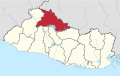
Chalatenango is a town and municipality in the Chalatenango department of El Salvador. It is the capital of the department. As of 1 May 2021, Alfredo Hernández of Nuevas Ideas (NI) is the municipality's mayor.

<span class="mw-page-title-main">Dulce Nombre de María</span> Municipality in Chalatenango Department, El Salvador

Dulce Nombre de María is a town and municipality in the Chalatenango Department of El Salvador. It is located 72 kilometers (45 mi) from San Salvador, the capital of El Salvador.

<span class="mw-page-title-main">La Palma, Chalatenango</span> Municipality in Chalatenango Department, El Salvador

La Palma is a municipality in the Chalatenango department of El Salvador. The municipality, located in a mountainous area of the country, covers an area of 135.60 km2 and as of 2006 had an approximate population of 24,000.

Las Vueltas is a municipality in the Chalatenango Department in the north of El Salvador. The municipality is bordered to the north by Ojos de Agua, to the east by Las Flores, to the south by Chalatenango, and to the northeast by Concepción Quezaltepeque. The territory covers 36.83 km² and the population was, as of 2005, of 2,101 inhabitants. For its administration, the municipality is divided into six cantones and 35 caseríos.

<span class="mw-page-title-main">Suchitoto</span> Municipality in Cuscatlan, El Salvador

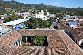
Suchitoto is a municipality in the Department of Cuscatlán, El Salvador that has seen continuous human habitation long before Spanish colonization. Within its municipal territory, Suchitoto holds the site of the original founding of the Villa of San Salvador in 1528 that existed for a short time before the site was abandoned. In more recent times, the municipality has prospered even after the severe effects of civil war in El Salvador that lasted between 1980 - 1992 and saw the population of Suchitoto decrease from 34,101 people in 1971 to 13,850 by 1992. It has become an important tourist destination partly due to its well conserved colonial architecture and cobblestone roads that provide a sense of Spanish colonial living. This rise in tourism has attracted service sector businesses to open up in the small city including hostels, restaurants, and picturesque cafes. As a result of tourism, many arts and cultural spaces have opened up in Suchitoto that are also providing positive alternative opportunities for youth in the community. According to the 2007 Official Census, the small city has a population of 24,786 people with 7,654 people living in the urban area and 17,132 people living in the rural communities.

San Isidro is a municipality in the Cabañas department of El Salvador, roughly 70 kilometres (43 mi) northeast of San Salvador.

<span class="mw-page-title-main">Chalatenango, El Salvador</span> Municipality in Chalatenango Department, El Salvador

Chalatenango is a municipality located in the Department of Chalatenango, in the north of El Salvador.

<span class="mw-page-title-main">San Jose Ojos de Agua, El Salvador</span> Municipality in Chalatenango, El Salvador

San Jose Ojos de Agua is a municipality is located in the department of Chalatenango in the North of El Salvador

Concepción Quetzaltepeque is a municipality in the department of Chalatenango in the north of El Salvador. It is bordered to the north by Comalapa and La Laguna, to the east by Las Vueltas and Chalatenango, to the south by Chalatenango, and to the west by Santa Rita. The territorial extension of the municipality is 52.54 km2. In 2005 the population was 6,734 inhabitants. The municipality's administration is divided into 6 cantons and 14 caserío.

El Carrizal is a municipality located in the department of Chalatenango in the North of El Salvador.

La Laguna is a municipality in the Chalatenango department of El Salvador.

The Cerrón Grande Hydroelectric Dam spans the Lempa River 78 km (48 mi) north of San Salvador in the municipalities of Potonico, (Chalatenango) and Jutiapa (Cabañas) in El Salvador.

Club Deportivo Atlético Comalapa is a Salvadoran professional football club based in Chalatenango, El Salvador.

<span class="mw-page-title-main">Canton El Tablon</span> Flooded locality in El Salvador

Canton El Tablón belonged to the Municipality of Suchitoto, Cuscatlan, El Salvador. El Tablón was one of many cantons in the surrounding area that was flooded as a result of the Cerron Grande Hydroelectric Dam built in El Salvador between 1972-1976 that created the artificial Lake Suchitlán. According to former residents of El Tablon, the area was divided up into four main wikt:caseríos or hamlets, Caserio La Hacienda Vieja, Caserio Los Figueroas, Caserio Valle El Tablón, and Caserio Los Palitos. It is unclear where the name El Tablon originated from, but according to local historians, an aldea or village/hamlet of El Tablón existed prior to 1860 that was formed through a municipal ejido. An ejido was commonly owned municipal land granted by the Spanish Crown to governing bodies in the Spanish Empire. These lands were considered vacant or unused land in some cases belonging to existing indigenous communities.

References

  1. Embajada de El Salvador en EE. UU.
  2. "Weak Foundations". Publishing.cdlib.org.
  3. "Background Info | El Salvador Travel Information | Lonely Planet Destination Guide". October 8, 2007. Archived from the original on October 8, 2007.
  4. CIA World Factbook. November 15, 2007. “El Salvador.” [Online]. https://www.cia.gov/ library/publications/the-world-factbook/geos/es.html. Retrieved December 5, 2007.
  5. US Bureau of Democracy, Human Rights, and Labor (USBHRL). November 8, 2005. “International Religious Freedom Report 2005.”
  6. Martínez Alas, José Salomón, Aguilardo Pérez Yancky, Ismael Ernesto Crespín Rivera, and Deysi Ester Cierra Anaya. 2005. “Diagnostico Cultural Municipio de Comalapa, 2005.” El Instituo para Rescate Ancestral Indígena (RAIS): El Salvador. Reprinted with express permission of the Unidad Tecnica Intermunicipal de La Mancomunidad la Montañona, who commissioned the report.

Bibliography