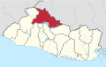
San Marcos is a department in northwestern Guatemala, on the Pacific Ocean and along the western Guatemala-Mexico border.

Suchitoto is a municipality in the Department of Cuscatlán, El Salvador that has seen continuous human habitation long before Spanish colonization. Within its municipal territory, Suchitoto holds the site of the original founding of the Villa of San Salvador in 1528 that existed for a short time before the site was abandoned. In more recent times, the municipality has prospered even after the severe effects of civil war in El Salvador that lasted between 1980 - 1992 and saw the population of Suchitoto decrease from 34,101 people in 1971 to 13,850 by 1992. It has become an important tourist destination partly due to its well conserved colonial architecture and cobblestone roads that provide a sense of Spanish colonial living. This rise in tourism has attracted service sector businesses to open up in the small city including hostels, restaurants, and picturesque cafes. As a result of tourism, many arts and cultural spaces have opened up in Suchitoto that are also providing positive alternative opportunities for youth in the community. According to the 2007 Official Census, the small city has a population of 24,786 people with 7,654 people living in the urban area and 17,132 people living in the rural communities.

Comitancillo is a town and municipality in the San Marcos department of Guatemala.The spoken language is Mam.The municipality was founded by the Spaniards between 1633 and 1648 year. There is an archaeological site called Chipel, with remains of the Mam culture.
Concepción Tutuapa is a town and municipality in the San Marcos department of Guatemala. It had a population of 49,363 according to the census of 2002 and of the 2018 census there is a total population of 68,148.
Ixchiguán is a municipality in the San Marcos department of Guatemala. The economy is based on temporary work force on the coffee plantations, respectively on a male migrating work force in Mexico.

Tejutla is a municipality in the western highlands of Guatemala, in the department of San Marcos. Tejutla was officially founded on 25 July 1672, although it was already an important town within the Mam kingdom in 1524, at the time of the Spanish conquest of Guatemala. It is situated high in the mountains, the so-called "cold zone", at about 2500 m altitude.
Sibinal is a municipality in the San Marcos department of Guatemala. Its name comes from mam tziben (English: "Writing" and nal, meaning "Bernard writings" It was founded in February 1799. It is a mountainous municipality at an altitude about 2500 m near the Mexican-Guatemalan border. The village of Sibinal is one of the points for climbing towards the Volcano Tacaná.
Sipacapa is a municipality in the San Marcos department, situated in the Western highlands of Guatemala. Sipacapa's population of around 14,000 is spread among 14 village communities, scattered over mountainous terrain. Sipacapa is considered a linguistic community, as Sipakapense is a Maya language unique to the municipality.
Tacaná is a town and municipality in the Guatemalan department of San Marcos.
Tajumulco is a municipality in the San Marcos department of Guatemala.

Nechi is a town and municipality in the Colombian department of Antioquia.

Escazú is the second canton in the province of San José in Costa Rica.

Puriscal is the 4th canton in the province of San José, Costa Rica.
Talamanca is a canton in the Limón province of Costa Rica. The head city is Bribri, located in Bratsi district.
The demographic history of Peru can be reconstructed through the population censuses carried out throughout the history of Peru. The following table provides the official results of censuses undertaken in the 19th and 20th centuries.
Jiménez is a canton in the Cartago province of Costa Rica. The head city is in Juan Viñas district.

Alajuelita is a canton in the San José province of Costa Rica.

Aguarico Canton is a canton of Ecuador, located in the Orellana Province. Its capital is the town of Nuevo Rocafuerte. Its population at the 2010 census was 4,658 INEC 2010.
Peruvian Sign Language ) is a Peruvian language created and used by the Deaf community in Peru. It has been officially recognized by Peruvian law since 2010. It is not clear how many users there are in the country; the most recent general census registered little more than 10,000, but the more specific census on people with special needs found around half a million people with hearing disabilities.
Pozos is a district in Santa Ana canton, San José province of Costa Rica. It was created in 1907. The principal avenue of the district carries the name of Lindora, which is also used to name the district and its surroundings.
This page is based on this
Wikipedia article Text is available under the
CC BY-SA 4.0 license; additional terms may apply.
Images, videos and audio are available under their respective licenses.