
Carbon is a rural hamlet in Douglas Township, Adams County, Iowa, United States. The population was 36 at the 2020 census. There is a church at Carbon, and a community center, and no other businesses or services. It is the 24th smallest place in Iowa by population.

Centerville is a city in and the county seat of Appanoose County, Iowa, United States. The population was 5,412 in the 2020 census, a decline from 5,924 in 2000. After the turn of the 20th century Centerville's coal mining industry attracted European immigrants from Sweden, Italy, Croatia, and Albania. Centerville is also home of the largest town square in the state of Iowa.

Mystic is a city in Appanoose County, Iowa, United States. The population was 322 at the time of the 2020 census.

What Cheer is a city in Keokuk County, Iowa, United States. It is a former coal town, and from the 1870s to the early 1900s was one of the major coal-producing centers of Iowa. Its greatest recorded population was 3,246, in the 1890 census. The population was 607 in the 2020 census.

Lucas is a city in Lucas County, Iowa, United States. The population was 172 at the time of the 2020 census.

Oskaloosa is a city in, and the county seat of, Mahaska County, Iowa. In the late nineteenth and early twentieth century, Oskaloosa was a national center of bituminous coal mining. The population was 11,558 in the 2020 U.S. census.

Bussey is a city in southeast Marion County, Iowa, United States. The population was 387 at the time of the 2020 census.
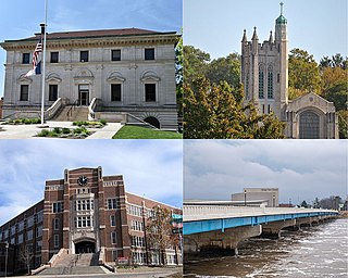
Ottumwa is a city in and the county seat of Wapello County, Iowa, United States. The population was 25,529 at the time of the 2020 U.S. Census. Located in the state's southeastern section, the city is split into northern and southern halves by the Des Moines River.

Seymour is a city in Wayne County, Iowa, United States. The population was 634 at the time of the 2020 census.
Coalville is a census-designated place (CDP) in Webster County, Iowa, United States. The population was 651 at the 2020 census. The community is located on U.S. Route 20 near Fort Dodge's large gypsum mines.

Lehigh is a city in Webster County, Iowa, United States. The population was 395 at the time of the 2020 census.

Berwick is an unincorporated community in Polk County, Iowa, United States, on the east bank of Fourmile Creek. It is part of the Des Moines–West Des Moines Metropolitan Statistical Area.

Luxor is an unincorporated community and coal town in Hempfield Township, Westmoreland County, Pennsylvania, United States.
Dorchester is an unincorporated community in northwestern Allamakee County, Iowa, United States. It lies along local roads just off Iowa Highway 76, north of the city of Waukon, the county seat of Allamakee County. Its elevation is 738 feet (225 m). The town was originally settled by Harvey Bell and Edmund Bell, and was named after Dorchester, England. Although Dorchester is unincorporated, it has a post office, with the ZIP code of 52140, which opened on 21 May 1857. Dorchester is located in Waterloo Township.

Sperry is an unincorporated community and census-designated place in central Des Moines County, Iowa, United States. It lies along local roads north of the city of Burlington, the county seat of Des Moines County. Its elevation is 751 feet (229 m). Although Sperry is unincorporated, it has a post office with the ZIP code of 52650, which opened on 5 February 1870.
The Consolidation Coal Company (BBC) was founded in 1875 in Iowa and purchased by the Chicago and North Western Railroad in 1880 in order to secure a local source of coal. The company operated in south central Iowa in Mahaska and Monroe counties until after World War I. Exhaustion of some resources, competition from overseas markets, and other changes led to the company's closing down its mines and leaving its major planned towns by the late 1920s. The CCC worked at Muchakinock in Mahaska County until the coal resources of that area were largely exhausted. In 1900, the company purchased 10,000 acres (40 km2) in southern Mahaska County and northern Monroe County, Iowa.
Charles Rollin Keyes was a U.S. geologist and in 1918 was a U.S. Senate candidate in Iowa. Born in Des Moines, Iowa, he graduated from the State University of Iowa in 1887. He worked for the United States Geological Survey. He earned a Ph.D. from Johns Hopkins University in 1892. He served as Assistant State Geologist of Iowa, Director of the Bureau of Geology and Mines of Missouri and was president of the New Mexico Institute of Mining and Technology at Socorro. Keyes was also an avid ornithologist, publishing the first detailed listing of birds in Iowa in 1889. In 1918 he was the Democratic candidate for the U.S. Senate from Iowa, losing to William S. Kenyon.
Enterprise is an unincorporated community in Polk County, Iowa, United States. Enterprise is located in Douglas Township. The state capital and county seat of Des Moines is located slightly less than 10 miles away.
Zook Spur is a former unincorporated community at the border of Dallas County and Polk County, in the U.S. state of Iowa. It was at the corner of what is now NW 158th Avenue and Iowa State Highway 17.
Zenorsville is an unincorporated community in Boone County, in the U.S. state of Iowa.

