Related Research Articles
The Potomac Heritage Trail, also known as the Potomac Heritage National Scenic Trail or the PHT, is a designated National Scenic Trail corridor spanning parts of the mid-Atlantic region of the United States that will connect various trails and historic sites in Virginia, Maryland, Pennsylvania, and the District of Columbia. The trail network includes 710 miles (1,140 km) of existing and planned sections, tracing the natural, historical, and cultural features of the Potomac River corridor, the upper Ohio River watershed in Pennsylvania and western Maryland, and a portion of the Rappahannock River watershed in Virginia. The trail is managed by the National Park Service.
The Monon Trail is a rail trail located entirely within the state of Indiana. The Monon Railroad was a popular railroad line connecting the cities of Chicago and Indianapolis, with stops at major settlements along its route. After the decline of railroad travel and the sale of the company in 1987, the portion of the line between Indianapolis and Delphi, Indiana, was abandoned.

Pinnacle Mountain State Park is a 2,356-acre state park located in Pulaski County, Arkansas just outside of Little Rock. The main attraction is Pinnacle Mountain, an iconic landmark surrounded by the bottomlands of the Big Maumelle and Little Maumelle rivers.

The OC&E Woods Line State Trail is a rail trail in Klamath and Lake counties in the U.S. state of Oregon. It is Oregon's longest state park. The trail follows the old OC&E and Weyerhaeuser railroads from Klamath Falls to Thompson Reservoir. Along its 105-mile (169 km) length it passes through the communities of Olene, Sprague River, Dairy, Beatty, and Bly.

The Paumanok Path is a 125-mile (201 km) hiking trail in New York on Long Island that goes from Rocky Point to Montauk Point State Park. It travels through four towns in Suffolk County: Brookhaven, Riverhead, Southampton and East Hampton.
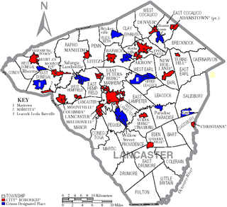
Transportation in Lancaster County, Pennsylvania has a long and variegated history. An early-settled part of the United States, and lying on the route between Philadelphia and Harrisburg, it has been the site of early experiments in canals, railroads, and highways. Before all these, at least ten Native American paths crossed parts of the county, many connecting with the Susquehannock village of Conestoga.
Conewago Creek is a 23.0-mile-long (37.0 km) tributary of the Susquehanna River in Lebanon, Dauphin, and Lancaster counties in Pennsylvania in the United States. The source is at an elevation of 1,100 feet (340 m) at Mount Gretna Heights in Lebanon County. The mouth is the confluence with the Susquehanna River at an elevation of 261 feet (80 m) at the border of Dauphin and Lancaster counties, just south of Three Mile Island in the river and just north of the unincorporated village of Falmouth in Conoy Township, Lancaster County.
Pennsylvania Route 441 is a 32-mile-long (51 km) state route in central Pennsylvania that mostly parallels the Susquehanna River through Lancaster and Dauphin counties. The southern terminus is at PA 999 in the Manor Township hamlet of Washington Boro. The northern terminus is at Paxton Street in Harrisburg. The route heads north from Washington Boro to Columbia, where it intersects U.S. Route 30. PA 441 continues up the river to Marietta and turns west, heading northwest past Bainbridge before leaving Lancaster County for Dauphin County. Here, the route continues north and passes along the east side of the former Three Mile Island Nuclear Generating Station before passing through the boroughs of Royalton and Middletown. Past Middletown, PA 441 heads away from the Susquehanna River and continues northwest, intersecting the PA 283 freeway indirectly and then Interstate 283 (I-283). The route passes through Oberlin before it comes to its northern terminus on the eastern edge of Harrisburg.

The Cape Cod Rail Trail (CCRT) is a 25.5-mile (41.0 km) paved rail trail located on Cape Cod in Massachusetts. The trail route passes through the towns of Yarmouth, Dennis, Harwich, Brewster, Orleans, Eastham, and Wellfleet. It connects to the 6-plus mile (10 km) Old Colony Rail Trail leading to Chatham, the 2 mile Yarmouth multi-use trail, and 8 miles (13 km) of trails within Nickerson State Park. Short side trips on roads lead to national seashore beaches including Coast Guard Beach at the end of the Nauset Bike Trail in Cape Cod National Seashore. The trail is part of the Claire Saltonstall Bikeway.
Pennsylvania Route 241 is a 23.6-mile-long (38.0 km) state highway in the U.S. state of Pennsylvania. The route runs from PA 441 in Conoy Township, Lancaster County northeast to PA 72 in the city of Lebanon in Lebanon County. The route heads east from PA 441 to Elizabethtown, where it runs concurrent with both PA 230 and PA 743. PA 241 continues into Lebanon County and intersects PA 341 and PA 117 in Colebrook. The route heads northeast and forms a concurrency with U.S. Route 322 before continuing to Lebanon.
The Shenipsit Trail is a Blue-Blazed hiking trail located in Central Connecticut between 3.5 and 7 miles (11 km) east of the Connecticut River. It runs 50 miles (80 km) in a north-south direction. The southern trailhead is on Gadpouch Road in Cobalt, CT on the southern end of the Meshomasic State Forest. The northern trailhead is on Greaves Road past Bald Mountain and the Shenipsit State Forest in Stafford, CT. The trail runs primarily through the Shenipsit and Meshomasic State Forests, and Case Mountain, but also utilizes other public and private land holdings. The Native American name Shenipsit means at the great pool, referring to the Shenipsit Lake, which the trail passes by. The Shenipsit Trail is divided into three sections: South, Central, and North. The Shenipsit Trail is one of the blue-blazed hiking trails managed by the Connecticut Forest and Park Association (CFPA).
Falmouth is an unincorporated community and census-designated place (CDP) in Conoy Township, Lancaster County, Pennsylvania, United States. As of the 2010 census the population was 420.

Bainbridge is an unincorporated community and census-designated place (CDP) in Conoy Township, Lancaster County, Pennsylvania, United States, with a ZIP code of 17502. Bainbridge is located along Pennsylvania Route 441. As of the 2010 census the population was 1,355.

The Tunxis Trail is a 79-mile (127 km) Blue-Blazed hiking trail "system" that traverses the western ridge of the central Connecticut Valley. The mainline trail is not completely contiguous, notably there are two gaps of several miles.
The Naugatuck Trail is a 6.8-mile (10.9 km) Blue-Blazed hiking trail "system" in the eastern central-lower Naugatuck River Valley in New Haven County, Connecticut, USA. It is almost entirely contained in the Naugatuck State Forest. The mainline trail is primarily east to west with three short side or spur trails. Composed of four trails, at its western end the trail ends with a section alongside Route 8 and the Naugatuck River. During the 1930s and 1940s, it was much larger. But post–World War II housing developments of the Connecticut Blue-Blazed Trails, led to its drastic reduction.

The Paugussett Trail is a 14-mile (23 km) Blue-Blazed hiking trail "system" in the lower Housatonic River valley in Fairfield County and, today, is entirely in Shelton and Monroe, Connecticut. Much of the trail is in Indian Well State Park and the Town of Monroe's Webb Mountain Park. The mainline trail is primarily southeast to northwest with three short side or spur trails.

The Natchaug Trail is a Blue-Blazed hiking trail "system" which meanders through 19.5 miles (31.4 km) of forests in northeast Connecticut—primarily in Windham County. It is maintained by the Connecticut Forest and Park Association. Its southern trailhead begins in the James L. Goodwin State Forest in the towns of Chaplin, Connecticut and Hampton, Connecticut and the northern terminus is at its intersection with the Nipmuck Trail in Natchaug State Forest in Eastford, Connecticut.

The Conewago Recreation Trail is a public recreational rail trail that follows the once Cornwall-Lebanon Railroad rail corridor for a total of slightly over 5.0 miles. The trail stretches from Elizabethtown, PA to the Lebanon County Line, PA, at which point it links up to the Lebanon Valley Rail Trail which continues for another 15.0 miles. The Conewago Recreation Trail runs adjacent to the Conewago Creek running through quiet farmland and forested areas.
The Northwest Lancaster County River Trail is a 14-mile trail located along the Susquehanna River in Lancaster County, Pennsylvania, United States of America.

The Lebanon Valley Rail Trail (LVRT) is a National Recreation Trail. The rail trail goes from the southwestern border of Lebanon County and goes through Colebrook, Mt. Gretna, Cornwall, and the city of Lebanon. At the southern border of Lebanon County, Pennsylvania the LVRT connects with the Conewago Recreation Trail and continues for another 5.0 miles (8.0 km). The trail is partly built on the old Cornwall–Lebanon Railroad created by industrialist Robert Coleman in the 1880s. The trail runs 15.0 miles (24.1 km), and there are many phases in development that would extend the trail to northern Lebanon County and Jonestown. The trail features a packed stone path and paved path at many parts that traverses "Pennsylvania Dutch Country" and other scenic routes. Trail users see untouched woodlands of state gamelands, forests, and views of area fields and farms. The trail is maintained by dedicated group of volunteers, and allows for running, walking, biking, horseback riding, and cross-country skiing.
References
- 1 2 3 "ExplorePATrails.com". Explorepatrails.com. Retrieved 14 December 2014.
- ↑ "Northwest Lancaster County River Trail". Taillink.com. Retrieved 14 December 2014.