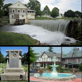
Newville is a borough in Cumberland County, Pennsylvania, United States. The borough is located west of Carlisle. The population was 1,376 at the 2020 census. It is part of the Harrisburg–Carlisle metropolitan statistical area.

Cumberland County is a county in the Commonwealth of Pennsylvania. As of the 2020 census, the population was 259,469. Its county seat is Carlisle.

Capital Area Transit (CAT), also known as rabbittransit Capital Region, is a regional public transportation agency that operates bus and paratransit service in the Harrisburg–Carlisle metropolitan statistical area. Its scheduled route bus service covers much of the southern half of Dauphin County and the eastern half of Cumberland County. It also operates two bus routes into northern York County. CAT's shared ride/paratransit operations serve residents throughout Dauphin County. In 2022, the system had a ridership of 1,200,800.

Lakelands Trail State Park, officially the Mike Levine Lakelands Trail State Park since January 20, 2017, is a state park in Michigan that runs east–west from southwest of Munith to Hamburg Township, Michigan. It is a multi-use trail converted from abandoned railroad corridors. According to the Michigan DNR web site, the north side of the trail is for hiking and biking, and the south side is for horseback riding. Based on the latest published DNR map the trail is 31.9 miles (51.3 km) long with the surface from Hawkins Rd. southwest of Munith to west of Pinckney composed of sections of crushed limestone, slag and sand, or unimproved. 10 miles (16 km) are paved in Hamburg Township from the first intersection with M-36 west of Pinckney to end of the park east of the Hamburg Rd. trailhead. A paved section of trail also extends from the edge of the park east of Hamburg Rd. to the west side of Whitmore Lake Rd., just south of its intersection with 9 Mile Rd in Green Oak Township.
The Banks–Vernonia State Trail is a paved rail trail and state park in northwest Oregon in the United States. It runs for 21 miles (34 km), primarily north–south, between the towns of Vernonia in Columbia County and Banks in Washington County on an abandoned railroad bed. Banks is about 25 miles (40 km) west of Portland.

Colonel Denning State Park is a 273-acre (110 ha) Pennsylvania state park in Lower Mifflin Township, Cumberland County, Pennsylvania in the United States. The park is in the Doubling Gap of Blue Mountain on Pennsylvania Route 233 between Newville and Landisburg. Doubling Gap Lake is a man-made lake covering 3.5 acres (1.4 ha). Colonel Denning State Park is surrounded by Tuscarora State Forest.

The Cape Cod Rail Trail (CCRT) is a 25.5-mile (41.0 km) paved rail trail located on Cape Cod in Massachusetts. The trail route passes through the towns of Yarmouth, Dennis, Harwich, Brewster, Orleans, Eastham, and Wellfleet. It connects to the 6-plus mile (10 km) Old Colony Rail Trail leading to Chatham, the 2 mile Yarmouth multi-use trail, and 8 miles (13 km) of trails within Nickerson State Park. Short side trips on roads lead to national seashore beaches including Coast Guard Beach at the end of the Nauset Bike Trail in Cape Cod National Seashore. The trail is part of the Claire Saltonstall Bikeway.
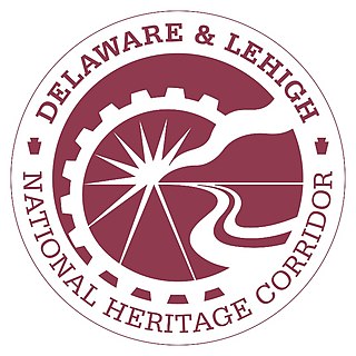
The Delaware & Lehigh Canal National and State Heritage Corridor (D&L) is a 165-mile (266 km) National Heritage Area in eastern Pennsylvania in the United States. It stretches from north to south, across five counties and over one hundred municipalities. It follows the historic routes of the Lehigh and Susquehanna Railroad, Lehigh Valley Railroad, the Lehigh Navigation, Lehigh Canal, and the Delaware Canal, from Bristol northeast of Philadelphia to Wilkes-Barre in the northeastern part of the state.
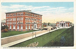
The Cumberland Valley Railroad was an early railroad in Pennsylvania, United States, originally chartered in 1831 to connect with Pennsylvania's Main Line of Public Works. Freight and passenger service in the Cumberland Valley in south central Pennsylvania from near Harrisburg to Chambersburg began in 1837, with service later extended to Hagerstown, Maryland, and then extending into the Shenandoah Valley to Winchester, Virginia. It employed up to 1,800 workers.

The Springwater Corridor Trail is a bicycle and pedestrian rail trail in the Portland metropolitan area in Oregon, United States. It follows a former railway line from Boring through Gresham to Portland, where it ends south of the Eastbank Esplanade. Most of the corridor, about 21 miles (34 km) long, consists of paved, off-street trail, though about 1 mile (1.6 km) overlaps city streets in Portland's Sellwood neighborhood. A large segment roughly follows the course of Johnson Creek and crosses it on bridges many times. Much of the corridor was acquired by the City of Portland in 1990; remaining segments were acquired by Metro thereafter.
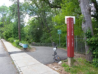
The Traction Line Recreation Trail is a multi-use paved asphalt rail trail located in Morristown, New Jersey.
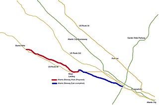
The Atlantic County Bikeway is a rail trail in Atlantic County, New Jersey.
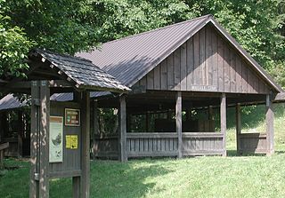
The Cumberland County Biker/Hiker Trail is a Pennsylvania rail trail at Pine Grove Furnace State Park and is almost entirely on the "Old Railroad Bed Road" between Fuller Lake and Laurel Lake. The trail is a pleasant 2.2 miles within the Pine Grove Furnace State Park located in the Michaux State Forest. The park is home to many species of wildlife and is a common attraction for locals and tourists alike. Walking, hiking, and biking are the opportunities offered by the trail year round. The biker/hiker trail shares roughly half of its trail with the Appalachian Trail and is a very popular route within the State Park.

The Letort Spring Run Nature Trail (LSRNT) is a rail trail in Carlisle, Pennsylvania. The trail stretches between Carlisle Borough's Letort Park and a trailhead approximately 2 miles (3.2 km) south at South Spring Garden Street. It parallels and twice crosses the Letort Spring Run, a limestone stream nationally recognized for its role in fly fishing heritage. The trail is an expression of the Letort Regional Authority's mission to promote appreciation of the Letort, as well as to protect the stream, greenway, and watershed from degradation.

The Conewago Recreation Trail is a public recreational rail trail that follows the once Cornwall-Lebanon Railroad rail corridor for a total of slightly over 5.0 miles. The trail stretches from Elizabethtown, Pennsylvania, to the Lebanon County Line, Pennsylvania, at which point it links up to the Lebanon Valley Rail Trail which continues for another 15.0 miles. The Conewago Recreation Trail runs adjacent to the Conewago Creek running through quiet farmland and forested areas.

The Lebanon Valley Rail Trail (LVRT) is a National Recreation Trail. The rail trail goes from the southwestern border of Lebanon County and goes through Colebrook, Mt. Gretna, Cornwall, and the city of Lebanon. At the southern border of Lebanon County, Pennsylvania the LVRT connects with the Conewago Recreation Trail and continues for another 5.0 miles (8.0 km). The trail is partly built on the old Cornwall–Lebanon Railroad created by industrialist Robert H. Coleman in the 1880s. The trail runs 15.0 miles (24.1 km), and there are many phases in development that would extend the trail to northern Lebanon County and Jonestown. The trail features a packed stone path and paved path at many parts that traverses "Pennsylvania Dutch Country" and other scenic routes. Trail users see untouched woodlands of state gamelands, forests, and views of area fields and farms. The trail is maintained by dedicated group of volunteers, and allows for running, walking, biking, horseback riding, and cross-country skiing.
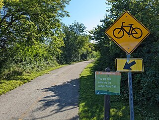
The Camp Chase Trail is a paved multi-use trail in Madison and Franklin counties in the U.S. state of Ohio. It serves as the Southwest Columbus segment of the 326-mile (525 km) Ohio to Erie Trail. The entire length of the Camp Chase Trail is part of the Great American Rail-Trail, U.S. Bicycle Route 21 and U.S. Bicycle Route 50.

The Willapa Hills Trail is a 56.0-mile (90.1 km) intercounty rail trail in the U.S. state of Washington that is part of the Willapa Hills State Park. Following an east–west route alongside State Route 6, the tract links Chehalis and South Bend, traveling through or near several small towns and parks along the way. Overseen by the Washington State Park System, local cities and towns often maintain areas of the trail within their jurisdictions. The trail is built upon a decommissioned railroad track.