Westmoreland Heritage Trail

Last updated
Westmoreland Heritage Trail
Length18.0 mi (29.0 km)
Location Westmoreland, Allegheny and Indiana counties, Pennsylvania, USA
Trailheads Trafford, Pennsylvania
40°23′06″N79°45′43″W / 40.385043°N 79.761981°W / 40.385043; -79.761981
Saltsburg, Pennsylvania
40°28′55″N79°26′51″W / 40.481809°N 79.447618°W / 40.481809; -79.447618
UseHiking, cycling
Elevation change eastern 338 feet (103 m);
western: 421.4 feet (128.4 m)
Highest point Salem Twp, PA, near PA Route 819, 1,193.5 ft (363.8 m)
Lowest pointeast end: 856 feet (261 m) at Saltsburg, Pennsylvania;
west end: 772.1 feet (235.3 m) at Trafford, Pennsylvania
Grade up to 2.08%
DifficultyEasy
Hazards Traffic (at road crossings)
Surface Crushed limestone (completed sections)
Right of way Turtle Creek Valley Railroad /
Turtle Creek Industrial Railroad
Website https://westmorelandheritagetrail.com/
Trail map

Contents

BSicon fLCONTg.svg
BSicon fLCONTgq.svg
BSicon fABZgLr.svg
connection to West Penn Trail
BSicon fHST.svg
Parking icon.svg Information icon.svg playground lot, Saltsburg
BSicon fSTR+GRZq.svg
Indiana / Westmoreland County
BSicon RP2q.svg
BSicon fTUNNEL2.svg
PA-981.svg PA 981
BSicon fHST.svg
Parking icon.svg Information icon.svg Steele lot, Loyalhanna Twp.
BSicon fHST.svg
Parking icon.svg Information icon.svg VFD lot, Slickville
BSicon fSTR.svg
BSicon RP2q.svg
PA-819.svg PA 819
BSicon fGIP.svg
Loyalhanna / Beaver Run divide
BSicon fKSTRe.svg
BSicon flBHF.svg
BSicon fexKSTRa.svg
Parking icon.svg Information icon.svg Rangos lot, near Delmont
BSicon fxGIP.svg
Beaver Run / Turtle Creek divide
BSicon fexSKRZ-G4u.svg
PA-66.svg PA 66
BSicon fexKSTRe.svg
BSicon flBHF.svg
BSicon fKSTRa.svg
Export
BSicon fSKRZ-G4u.svg
US 22.svg US 22
BSicon fSTR.svg
Emojione BW 1F332.svg Duff Park
BSicon fBHF.svg
BSicon fSTR.svg
Parking icon.svg Toilets unisex.svg Information icon.svg Roberts lot, Murrysville
BSicon fBHF.svg
BSicon fSTR.svg
Parking icon.svg Information icon.svg Carson Ave. lot, Murrysville
BSicon fSTR+GRZq.svg
Westmoreland / Allegheny County
BSicon fSKRZ-Bu.svg
I-76.svgPennsylvania Turnpike logo.svg I-76  / Penna Turnpike
BSicon fBHF.svg
BSicon fSTR.svg
Parking icon.svg Information icon.svg Saunders Station lot, Monroeville
BSicon fSTR+GRZq.svg
Allegheny / Westmoreland County
BSicon fBHF.svg
Parking icon.svg Bus stop symbol.svg Parkside Creamery lot, Trafford
BSicon fSTR.svg
Emojione BW 1F332.svg B-Y Park
BSicon RP2q.svg
BSicon fexTUNNEL2.svg
PA-130.svg PA 130
BSicon fexLCONTf.svg
proposed connection to GAP

The Westmoreland Heritage Trail is a partially completed rail trail in southwestern Pennsylvania. As of 2019, 18.0 miles of the 21.9 planned miles of trail are complete, including an 8.7 mile section from Saltsburg to the fringe of Delmont as well as a 9.3 mile section from Trafford to Export. [1]

Westmoreland Heritage Trail (interactive map) Westmoreland Heritage Trail.svg
Westmoreland Heritage Trail (interactive map)

Right of way

The trail as proposed follows a 21.9 mile long right-of-way that was once the Turtle Creek Branch of the Pennsylvania Railroad (PRR), a portion of which continued independent short-line operation as the Turtle Creek Industrial Railroad for decades after it was sold off by Conrail. The right of way proceeds from Saltsburg through Loyalhanna and Salem townships, alongside Delmont into the outskirts of Murrysville before passing through Export, the Murrysville business district, Monroeville and Penn Township, finally terminating in Trafford shortly before the remaining tracks merge into the Pittsburgh Line, which is still active. The portions of the trail that have thus far been constructed follow the former rail line rather faithfully. Ties and rails have been replaced primarily with crushed limestone (asphalt was used in short sections near road crossings), and old railroad bridges have been re-decked for use by cyclists and pedestrians.

Elevation

The elevation profile of the former railway that the Westmoreland Heritage Trail follows is a complex one. Rather than simply paralleling a single river as many rail-trails do, it instead runs alongside and over multiple waters, twice approaching 1200' as the right of way transitions between different watersheds. Beginning at the planned eastern terminus at 772.1' by the location of the former Trafford North Station, the trail follows Turtle Creek toward its headwaters near PA Route 66. Here the Pennsylvania Railroad's track maps show the old right of way crossing under the route through a tunnel at 1181.1' above sea level, however this tunnel has since been buried rendering it unusable. Since the path by which the trail will cross Route 66 is not yet decided, the ultimate elevation of this crossing remains unknown. From here the trail descends towards the causeway across the Beaver Run Reservoir at an elevation of 1069.8', rising again to its current high point of 1193.5' as it passes through a cut about 1/4 mile west of route 819. [2] From there the trail descends toward its western terminus at 856', [3] where it merges into the West Penn Trail.

Westmoreland Heritage Trail elevation profile. Note: central section between Export and Delmont not constructed as of 2019 Westmoreland Heritage Trail Elevation.svg
Westmoreland Heritage Trail elevation profile. Note: central section between Export and Delmont not constructed as of 2019

This descent eastward from Slickville represents the steepest gradient on the track chart at 2.08%. [2] Between Delmont and Saltsburg the trail departs from the rail grade for several road crossings previously made on rail overpasses which have since been removed, meaning that the actual slope of the trail exceeds the rail gradient for brief stretches. These grades are higher than those of some other prominent rail trails in the area; for example the Great Allegheny Passage lists its maximum as 1.5%. [4] However it is still well below the 5% limit set for the “running slope” of an accessible route under the Americans with Disabilities Act. [5] Farther away from the highpoints where the streams grow deeper, such as alongside Loyalhanna Creek, the trail becomes noticeably more level. Using a three-tiered evaluation system, Trans Allegheny Trails rates this section of the WHT as “easy”, while it rates the formerly mentioned steepest section near Slickville as “moderate” in cycling difficulty. [6]

Points of Interest

Landmarks

The (approximate) site where the Haymaker brothers struck natural gas in Murrysville, PA on November 3, 1878 Haymaker Gas Well in Murrysville April 2016.jpg
The (approximate) site where the Haymaker brothers struck natural gas in Murrysville, PA on November 3, 1878

The path of the Westmoreland Heritage Trail runs by several prominent landmarks associated with the old railroad and the industries that grew around it. The corridor of the eastern half of the trail is dotted with mine ruins and piles of slate left over from the coal industry; one of the most prominent of which is adjacent to the trail in Slickville, where the town's name is spelled out atop it. In the borough of Export sits a newly restored 1939 railroad caboose. [7] A model derrick as well as a plaque and display stand by the trail in Murrysville, honoring the gas well tapped by the Haymaker brothers in 1878, though the exact location of that well is not known precisely. [8] Finally, the ruins of a railroad bridge and the turn of the century brickyard once serviced by it lie across the creek from the trail in Monroeville near TCKR milepost number 2 in Trafford. [9] [10]

Parks

The Westmoreland Heritage Trail in B-Y Park; Trafford, PA Westmoreland Heritage Trail in B-Y Park.jpg
The Westmoreland Heritage Trail in B-Y Park; Trafford, PA

The trail also runs by and through several parks and recreational areas. The trail begins in Saltsburg next to a small playground. Export has plans to build a new park next to the trail that is set to extend through the borough. [11] Farther west the trail runs alongside Murrysville's Duff Park, which has a biking trail and several hiking trails. Neighboring Monroeville owns several parcels of land across the water from the trail, including Alpine Park and Valley Park, however a lack of nearby bridges over Turtle Creek currently limits access to them. The last major park the trail runs through before its current western terminus is B-Y Park in Trafford, which has picnic pavilions and a pond that is used for fishing and ice skating, depending on the season.

Construction history

Completed and planned

The WHT crosses over the Conemaugh River and under Rt 981 in Loyalhanna Township, PA Conemaugh River bridge and Rt 981 Tunnel May 2017.jpg
The WHT crosses over the Conemaugh River and under Rt 981 in Loyalhanna Township, PA

Nearly nine years passed between the time the discussion of the WHT began in 1998 and when the first section was built. [12] With this first five-mile segment from Saltsburg to Slickville completed, momentum for development of the trail continued to grow, and a 3.7 mile westward extension towards Delmont was opened in 2013. [13] The following year, trail developers set their sights on the Turtle Creek valley, when they raised the funds to purchase the right of way of the Turtle Creek Industrial Railway. [14] Construction on a 5.9 mile section of this corridor between Trafford and Monroeville was completed in the fall of 2017, [15] and construction of a further 3.4 mile section from Murrysville to Export was completed in the summer of 2019. [16] [17] [18] [19]

Future goals

Which section will be built next and when is not yet certain. The future connection between Export and Delmont is complicated by the need to cross PA route 66, a busy highway once traversed by a railroad tunnel that is now buried. [20] In 2018 a grant was awarded to fund a study of the possible development of the trail on this ~4 mile segment. [21] On the western front, expansion from Trafford must first involve acquisition of the rights to the final fraction of a mile of the Turtle Creek Industrial Railway, currently owned by Norfolk Southern. [22] [23] From here the trail could continue alongside Turtle Creek through East Pittsburgh, and some proposed trail maps imply that this could be done along the abandoned East Pittsburgh Branch of the PRR, where the Westinghouse Interworks Railway once ran. [24] [25]

Connecting trails

Mega Greenways

The Westmoreland Heritage Trail (left) meets the West Penn Trail in Saltsburg, PA Westmoreland Heritage Trail and West Penn Trail May 2017.jpg
The Westmoreland Heritage Trail (left) meets the West Penn Trail in Saltsburg, PA

At its eastern terminus, the WHT connects seamlessly to the West Penn Trail, which is part of the 320 mile Pittsburgh-to-Harrisburg Main Line Canal Greenway. [26] On its western end the Westmoreland Heritage Trail has no connections as of yet, however continuing the trail downstream along Turtle Creek and through Braddock would allow the WHT to connect to the Steel Valley Trail, [27] a connection that members of both respective trail councils have expressed support in making. [28] [29] [30] [31] This would link the WHT with the Great Allegheny Passage, a 150-mile rail-trail from Pittsburgh to Cumberland, Maryland, which, along with the Chesapeake and Ohio Canal towpath trail, forms a continuous hiking and biking trail between Pittsburgh and Washington, DC.

Rough Diamond Trail Project

The Westmoreland Heritage Trail is also part of the Rough Diamond Trail Project, a circuit of completed and proposed trails between Pittsburgh, Freeport, Saltsburg and Trafford that is being promoted by locally born actor David Conrad [32] He has produced and starred in two videos thus far about this project. The first shows the WHT only briefly, [33] while the second features Conrad riding through a few different sections of the trail, which includes the Turtle Creek gorge before the railroad tracks were removed. [34]

Related Research Articles

<span class="mw-page-title-main">Westmoreland County, Pennsylvania</span> County in Pennsylvania, United States

Westmoreland County is a county in the Commonwealth of Pennsylvania, United States. As of the 2020 census, the population was 364,663. The county seat is Greensburg and the most populous community is Hempfield Township. It is named after Westmorland, a historic county of England.

<span class="mw-page-title-main">Monroeville, Pennsylvania</span> Borough in Pennsylvania, United States

Monroeville is a home rule municipality in Allegheny County, Pennsylvania, United States. It is a suburb with mixed residential and commercial developments located about 10 miles (16 km) east of Pittsburgh. As of the 2020 census, Monroeville was home to 28,640 people.

<span class="mw-page-title-main">North Versailles Township, Allegheny County, Pennsylvania</span> Township in Pennsylvania, United States

North Versailles is a first class township in Allegheny County, Pennsylvania, United States. The population was 10,079 at the 2020 census. The township derives its name from the Palace of Versailles.

<span class="mw-page-title-main">Plum, Pennsylvania</span> Borough in Pennsylvania, United States

Plum is a borough in Allegheny County, Pennsylvania, United States. The population was 27,144 at the 2020 census. A suburb of the Pittsburgh metropolitan area, it is located northeast of the city in what is commonly referred to as the East Hills suburbs.

<span class="mw-page-title-main">Murrysville, Pennsylvania</span> Home rule municipality in Pennsylvania, United States

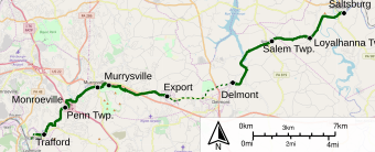
Murrysville is a home rule municipality in Westmoreland County, Pennsylvania, United States. The population was 21,006 at the 2020 census. It is part of the Pittsburgh metropolitan area.

<span class="mw-page-title-main">Penn Township, Westmoreland County, Pennsylvania</span> Township in Pennsylvania, United States

Penn Township is a township in Westmoreland County, Pennsylvania, United States.

<span class="mw-page-title-main">Slickville, Pennsylvania</span> CDP in Pennsylvania, United States

Slickville is a census-designated place (CDP) in Westmoreland County, Pennsylvania, United States. The population was 372 at the 2000 census.

<span class="mw-page-title-main">Trafford, Pennsylvania</span> Borough in Pennsylvania, United States

Trafford is a borough in Allegheny and Westmoreland counties in the U.S. state of Pennsylvania. Located near Pittsburgh in western Pennsylvania, the borough lies primarily in Westmoreland County; only a small portion extends into Allegheny County. It was incorporated in 1904 from the northernmost corner of North Huntingdon Township, and was named by George Westinghouse for Trafford near Manchester, England. Westinghouse purchased the land in 1902, and the Trafford Foundry began operations on October 3, 1903. The population was 3,317 at the 2020 census. Of this, 3,113 were in Westmoreland County, and only 61 were in Allegheny County.

<span class="mw-page-title-main">Wilkins Township, Allegheny County, Pennsylvania</span> Township in Pennsylvania, United States

Wilkins Township is a township in Allegheny County, Pennsylvania, United States. The population was 6,357 at the 2010 census. It is served by Pennsylvania's 12th congressional district, the 43rd District of the Pennsylvania State Senate, and the 34th District of the Pennsylvania State House of Representatives.

<span class="mw-page-title-main">Great Allegheny Passage</span> Rail trail connecting Cumberland, Maryland and Pittsburgh, Pennsylvania

The Great Allegheny Passage (GAP) is a 150-mile (240 km) rail trail between Pittsburgh, Pennsylvania and Cumberland, Maryland. Together with the C&O Canal towpath, the GAP is part of a 335 mi (539 km) route between Pittsburgh and Washington, D.C., that is popular with through hikers and cyclists.

<span class="mw-page-title-main">Franklin Regional School District</span> School district in Pennsylvania

Franklin Regional School District is a midsized, suburban public school district located in Murrysville, Pennsylvania, serving Murrysville and the neighboring communities of Delmont and Export. Franklin Regional School District encompasses approximately 38 square miles (98 km2). According to 2020 federal census data, it serves a resident population of 19,438 people. According to District officials, in school year 2021-22, Franklin Regional School District provided basic educational services to 3,555 pupils through the employment of 249 teachers, 152 full-time and part-time support personnel, and 19 administrators.

<span class="mw-page-title-main">Transportation in Pittsburgh</span> Transportation in Pittsburgh, Pennsylvania, United States

Transportation in Pittsburgh, Pennsylvania is different than in many other major American cities. A large metropolitan area that is surrounded by rivers and hills, Pittsburgh has an infrastructure system that has been built out over the years to include roads, tunnels, bridges, railroads, inclines, bike paths, and stairways; however, the hills and rivers still form many barriers to transportation within the city.

<span class="mw-page-title-main">Pennsylvania Route 380</span> State highway in Pennsylvania, US

Pennsylvania Route 380, also known as J.F. Bonetto Memorial Highway and within the city of Pittsburgh Bigelow Boulevard, Baum Boulevard and Frankstown Road, is a 32.80 mi (52.8 km) long state highway in western portions of the U.S. state of Pennsylvania. The western terminus of the route is at Interstate 579 in downtown Pittsburgh near PPG Paints Arena. The eastern terminus is at Pennsylvania Route 286 in Bell Township, near the hamlet of Wakena.

<span class="mw-page-title-main">Turtle Creek (Monongahela River tributary)</span> River in Pennsylvania, United States

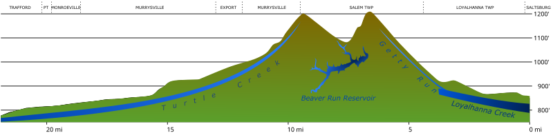
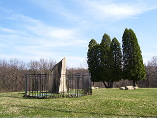
Turtle Creek is a 21.1-mile-long (34.0 km) tributary of the Monongahela River that is located in Allegheny and Westmoreland counties in the U.S. state of Pennsylvania. Situated at its juncture with the Monongahela is Braddock, Pennsylvania, where the Battle of the Monongahela was fought in 1755.

<span class="mw-page-title-main">Pennsylvania Route 130</span> State highway in Pennsylvania, US

Pennsylvania Route 130 (PA 130) is a 49-mile-long (79 km) state highway located in Allegheny and Westmoreland counties in Pennsylvania. The western terminus is at PA 8 in Pittsburgh, and the eastern terminus is at PA 381 near Kregar.

<span class="mw-page-title-main">Pennsylvania Route 286</span> State highway in Pennsylvania, US

Pennsylvania Route 286 is a 69-mile-long (111 km), east–west state highway located in Allegheny, Westmoreland, Indiana, and Clearfield counties in Pennsylvania.

<span class="mw-page-title-main">Turtle Creek Industrial Railroad</span> Former short line freight railroad in western Pennsylvania, United States

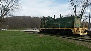
The Turtle Creek Industrial Railroad was a short line freight railroad that operated in western Pennsylvania between the boroughs of Export and Trafford, where it connected to the Pittsburgh Line. The TCKR was a wholly owned subsidiary of the Dura-Bond Corporation, a steel products company headquartered in Export. The company purchased the railroad from Conrail in 1982. For the next 27 years, three to five trains per week made the round trip along just over ten miles (16 km) of track, delivering materials such as steel pipe to the shortline's parent company in Export and lumber to lumber yards in neighboring Murrysville. In the shortline's heyday, trains of typically about four cars in length were hauled by one of the railroad's two 1940s era switch engines, operated by a two-man crew. The railroad was in service until 2009, when flash flooding of Turtle Creek severely damaged the TCKR's tracks which ran adjacent to the stream. After cessation of service, most of the right-of-way was sold to Westmoreland County to become part of the Westmoreland Heritage Trail.

The Westmoreland County Transit Authority (WCTA) is the operator of mass transportation in Westmoreland County, Pennsylvania. Using 35 buses, a total of 18 routes are operated, the majority of which serve the urbanized corridor that makes up the western portion of the county. Bus routes in this area are designed to provide access for suburban commuters to Downtown Pittsburgh, as well as transportation for both workers and shoppers to the large suburbs of Greensburg and New Kensington, Pennsylvania the most prominent entities in the county's boundaries. Rural eastern bus routes allow for commutes to Greensburg and also provide service to the city of Johnstown in neighboring Cambria County.

<span class="mw-page-title-main">Westinghouse Interworks Railway</span>

The Westinghouse Interworks Railway was a short line railroad that operated in the lower Turtle Creek valley east of Pittsburgh, Pennsylvania. A subsidiary of the Westinghouse Electric Corporation, the railway used former Turtle Creek Valley Railroad tracks that Westinghouse rebuilt and extended from Trafford through Wilmerding to East Pittsburgh along the right bank of the creek. The railroad transported freight between the Westinghouse plants and also tested and demonstrated electric rail cars.

References

  1. "Westmoreland Heritage Trail (official page)" . Retrieved 30 July 2019.
  2. 1 2 "No. IX Track Chart, Pennsylvania Railroad Pittsburgh Region, District - A Branches" (PDF). December 31, 1958.{{cite journal}}: Cite journal requires |journal= (help)
  3. "Google Maps Find Altitude" . Retrieved 25 February 2018.
  4. "The Great Allegheny Passage: Elevation Chart".
  5. "2010 ADA Standards for Accessible Design". 15 September 2010.
  6. "Trans Allegheny Trails: The Westmoreland Heritage Trail".
  7. Varine, Patrick (Aug 10, 2016). "Refurbished caboose to debut at Export Ethnic Food & Music Festival". Pittsburgh Tribune-Review.
  8. Signorini, Renatta (July 14, 2012). "Murrysville's gas well site denied historic status". Pittsburgh Tribune-Review.
  9. Chandler, Louis; Bullock, Paul. "The Brickyards of Patton Township". Trafford History. Monroeville Historical Society. Retrieved 13 July 2017.
  10. "Old Industry of Southwestern Pennsylvania : Monroeville Brickyard". 2 August 2015.
  11. Varine, Patrick (June 6, 2017). "Export taps into coal mining history to plan park". Pittsburgh Tribune-Review.
  12. Laurinatis, Judy (Jun 14, 2007). "Ground broken for Westmoreland trail". Pittsburgh Post-Gazette.
  13. Walsh, Larry (Sep 28, 2013). "Biking: New trail to Delmont complete". Pittsburgh Post-Gazette.
  14. Richards, Jeff; Grimm, Noel (July 2014). "Westmoreland Heritage Trail News" (PDF). Murrysville Trail News.
  15. Varine, Patrick (September 6, 2017). "Third phase of Westmoreland Heritage Trail will open Sept. 30". Pittsburgh Tribune-Review.
  16. Ulicne, Chris (July 26, 2019). "Westmoreland Heritage Trail phase 4 grand opening ceremony Aug. 17". Latrobe Bulletin.
  17. Varine, Patrick (November 15, 2018). "Bid awarded for fourth phase of Westmoreland Heritage Trail between Murrysville, Export". TribLive.
  18. Napsha, Joe (January 23, 2018). "Westmoreland Heritage Trail expansion plans to be unveiled". Trib Live.
  19. "Turtle Creek Extension of the Westmoreland Heritage Trail". Murrysville Trail Alliance. Retrieved 26 January 2018.
  20. Mance, Mike (April 5, 2014). "A closer look at Delmont Gas Coal Company's No. 2 Mine". Old Industry of Southwestern Pennsylvania. Retrieved 17 July 2017.
  21. "2018 Community Conservation Partnerships Program Grants List" (PDF). PA Department of Conservation and Natural Resources. Retrieved 19 November 2018.
  22. Foreman, Chris (Nov 12, 2014). "Grant brings federal funding of Westmoreland Heritage Trail to $1M". Pittsburgh Tribune-Review.
  23. McGee, Tom (April 27, 2016). "Westmoreland Heritage Trail supporters hope for cooperation from Norfolk Southern". Pittsburgh Tribune-Review.
  24. ACTIVE ALLEGHENY: A Comprehensive Commuter Bicycle and Pedestrian Transportation Plan for Allegheny County (PDF). Dec 2010. p. 153.
  25. Churchill - Monroeville - Wilkins: Implementable Comprehensive Plan for The Energetic East in Allegheny County (PDF). 2018. pp. 4–29 (93).
  26. "Pittsburgh-to-Harrisburg Main Line Canal Greenway".
  27. "Steel Valley Trail Council".
  28. "Westmoreland Heritage Trail Phase II Extension 3.7 miles, Slickville to Delmont Grand Opening" (PDF). Retrieved October 5, 2013.
  29. Foreman, Chris (Jul 16, 2014). "Old rail line from Trafford to Export could become trail". Pittsburgh Tribune-Review.
  30. Cloonan, Anne (Aug 12, 2016). "Work on next phase of Westmoreland Heritage Trail set to begin". Pittsburgh Post-Gazette.
  31. Heckbert, Paul (Jan 29, 2017). "Let's complete trails on both banks of the Mon". Pittsburgh Post-Gazette.
  32. Ingram, Sheldon (Jan 29, 2014). "'Agents of S.H.I.E.L.D.' villain uses powers for good as ambassador of Pittsburgh: David Conrad hoping Rough Diamond Trail Project will unite hometown". Pittsburgh's Action News 4.
  33. Knobil, Mark; Conrad, David; Blair, Ryan (31 December 2013). "The Rough Diamond Trail Project" . Retrieved 8 August 2017.
  34. Conrad, David; Blair, Ryan; Weiss, Robert (21 October 2014). "The Rough Diamond Trail Project / phase 2" . Retrieved 8 August 2017.