
Harrisburg is the capital city of the Commonwealth of Pennsylvania, United States, and the seat of Dauphin County. With a population of 50,135 as of 2021, Harrisburg is the ninth-largest city and 15th-largest municipality in Pennsylvania. Harrisburg is situated on the east bank of the Susquehanna River. It is the larger principal city of the Harrisburg–Carlisle metropolitan statistical area, also known as the Susquehanna Valley, which had a population of 591,712 as of 2020, making it the fourth-most populous metropolitan area in Pennsylvania after the Philadelphia, Pittsburgh, and Lehigh Valley metropolitan areas.

Mount Joy is a borough in Lancaster County, Pennsylvania, United States. The population was 8,346 at the 2020 census, and an estimated 8,323 in 2021.

Marietta is a borough in Lancaster County, Pennsylvania, United States. The population was 2,633 at the 2020 census. It is located on the east bank of the Susquehanna River, northwest of Columbia.

Dauphin is a borough in Dauphin County, Pennsylvania, United States. The population was 796 at the 2020 census. Dauphin's ZIP code is 17018. It is part of the Harrisburg–Carlisle Metropolitan Statistical Area.
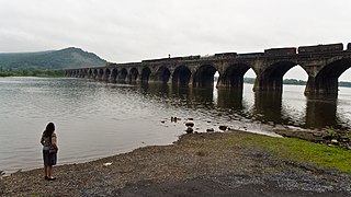
Susquehanna Township is a township in Dauphin County, Pennsylvania, United States. The population was 26,736 at the time of the 2020 census. This represents a 9.8% increase from the 2000 census count of 21,895. Susquehanna Township has the postal ZIP codes 17109 and 17110, which maintain the Harrisburg place name designation. The township is a suburb of Harrisburg and is connected to Marysville by the Rockville Bridge, the world's longest stone-arch rail bridge at the time of its completion.

The East Coast Greenway is a 3,000-mile (4,800 km) pedestrian and bicycle route between Maine and Florida along the East Coast of the United States. The nonprofit East Coast Greenway Alliance was created in 1991 with the goal to use the entire route with off-road, shared-use paths; as of 2021, over 1,000 mi (1,600 km) of the route (35%) meets this criteria. In 2020, the Greenway received over 50 million visits.

Swatara Creek is a 72-mile-long (116 km) tributary of the Susquehanna River in east-central Pennsylvania in the United States. It rises in the Appalachian Mountains in central Schuylkill County and passes through northwest Lebanon County before draining into the Susquehanna at Middletown in Dauphin County.

The Monon Trail is a rail trail located entirely within the state of Indiana. The Monon Railroad was a popular railroad line connecting the cities of Chicago and Indianapolis, with stops at major settlements along its route. After the decline of railroad travel and the sale of the company in 1987, the portion of the line between Indianapolis and Delphi, Indiana, was abandoned.

A greenway is usually a shared-use path along a strip of undeveloped land, in an urban or rural area, set aside for recreational use or environmental protection. Greenways are frequently created out of disused railways, canal towpaths, utility or similar rights of way, or derelict industrial land. Greenways also can also be linear parks, and can serve as wildlife corridors. The path's surface may be paved and often serves multiple users: walkers, runners, bicyclists, skaters and hikers. A characteristic of greenways, as defined by the European Greenways Association, is "ease of passage": that is that they have "either low or zero gradient", so that they can be used by all "types of users, including mobility impaired people".

Susquehanna State Park is a public recreation area located on the banks of the lower Susquehanna River north of the city of Havre de Grace, Maryland. The state park's main area is on the west bank of the river; the park also manages land on the river islands and east bank. The park offers fishing, boating, camping, and trails for hiking and equestrian use. It is managed as a complex with Rocks State Park and Palmer State Park by the Maryland Department of Natural Resources.
Transportation in Lancaster County, Pennsylvania has a long and variegated history. An early-settled part of the United States, and lying on the route between Philadelphia and Harrisburg, it has been the site of early experiments in canals, railroads, and highways. Before all these, at least ten Native American paths crossed parts of the county, many connecting with the Susquehannock village of Conestoga.
Conewago Creek is a 23.0-mile-long (37.0 km) tributary of the Susquehanna River in Lebanon, Dauphin, and Lancaster counties in Pennsylvania in the United States. The source is at an elevation of 1,100 feet (340 m) at Mount Gretna Heights in Lebanon County. The mouth is the confluence with the Susquehanna River at an elevation of 261 feet (80 m) at the border of Dauphin and Lancaster counties, just south of Three Mile Island in the river and just north of the unincorporated village of Falmouth in Conoy Township, Lancaster County.

Pennsylvania Route 441 is a 32-mile-long (51 km) state route in central Pennsylvania that mostly parallels the Susquehanna River through Lancaster and Dauphin counties. The southern terminus is at PA 999 in the Manor Township hamlet of Washington Boro. The northern terminus is at Paxton Street in Harrisburg. The route heads north from Washington Boro to Columbia, where it intersects U.S. Route 30. PA 441 continues up the river to Marietta and turns west, heading northwest past Bainbridge before leaving Lancaster County for Dauphin County. Here, the route continues north and passes along the east side of the former Three Mile Island Nuclear Generating Station before passing through the boroughs of Royalton and Middletown. Past Middletown, PA 441 heads away from the Susquehanna River and continues northwest, intersecting the PA 283 freeway indirectly and then Interstate 283 (I-283). The route passes through Oberlin before it comes to its northern terminus on the eastern edge of Harrisburg.

Chickies Ridge is a long ridge in West Hempfield Township, Lancaster County, Pennsylvania, terminating at the west end in an outcropping overlooking the Susquehanna River, known as Chickies Rock.

Pennsylvania Route 743 is a north–south state route located in central Pennsylvania. The southern terminus is at PA 441 in Marietta. The northern terminus is at U.S. Route 22 near the East Hanover Township hamlet of Grantville though some signage has it continue north past Interstate 81 (I-81) to PA 443. The route runs north through Lancaster County, passing through Maytown before reaching Elizabethtown. Here, the route has concurrencies with PA 230 and PA 241 and comes to an interchange with the PA 283 freeway. PA 743 continues into Dauphin County and crosses PA 341 before reaching Hershey. In Hershey, the route follows Cocoa Avenue between US 322 and US 422, the latter which is known as Chocolate Avenue. PA 743 follows Park Avenue north past Hersheypark and Hersheypark Drive east before heading north on Laudermilch Road from Hershey to Grantville.

The Capital Area Greenbelt is a looping trail located in the area of Harrisburg, Pennsylvania. This 20-mile loop around Pennsylvania's capital city provides visitors and tourists with opportunities to hike, ride bicycles, skate, jog, fish, walk their dogs, spot rare birds, learn about history, enjoy native flora and fauna, and appreciate nature. While parts of the trail are shared with roads, most of the loop is a dedicated path. The Trail, as it is commonly referred to by locals, passes along the Susquehanna River through Reservoir Park, Riverfront Park, Five Senses Garden, and Wildwood Park and Nature Center. In addition to parks, the Capital Area Greenbelt passes alongside attractions including the grave site of John Harris Sr., the Governor's Mansion, Fort Hunter, Harrisburg State Hospital, and the National Civil War Museum.

Bainbridge is an unincorporated community and census-designated place (CDP) in Conoy Township, Lancaster County, Pennsylvania, United States, with a ZIP code of 17502. Bainbridge is located along Pennsylvania Route 441. As of the 2010 census, the population was 1,355.
The Conestoga Trail System is a 65.8-mile (105.9 km) linear hiking trail in Lancaster County, Pennsylvania. The system connects several relatively short and discontinuous footpaths with walks on paved roads. About 53% of the network's distance is made up of road walking, and those segments are intended to showcase the rural scenery of Lancaster County, utilizing three covered bridges and passing numerous Amish and Mennonite farms, as well as some urban and suburban neighborhoods in and around Lancaster. The footpath segments offer wilderness scenery of the type that can be found in many of Pennsylvania's forested areas, plus some walks alongside farm fields.
The Conoy Canal Trail is a section of the planned Northwest Lancaster County River Trail, that runs for 3.75 miles along the Conewago Canal which stretches from Bainbridge to Falmouth. The canal was opened in 1797. The trail was developed for hikers, bikers, fisherman, and runners in the early 2000s.

