East Donegal Township, Lancaster County, Pennsylvania

Last updated

East Donegal Township, Pennsylvania
1402 Trout Run Byers Muma PA.JPG
East Donegal Township, Lancaster County, Highlighted.PNG
Map of Lancaster County, Pennsylvania highlighting East Donegal Township
Map of Pennsylvania highlighting Lancaster County.svg
Map of Lancaster County, Pennsylvania
Country United States
State Pennsylvania
County Lancaster
Settled1716
Incorporated1838
Government
  TypeBoard of Supervisors
Area
[1]
  Total23.76 sq mi (61.53 km2)
  Land21.43 sq mi (55.51 km2)
  Water2.32 sq mi (6.02 km2)
Population
 (2020) [2]
  Total8,690 Increase2.svg
  Estimate 
(2021) [2]
8,660
  Density387.97/sq mi (149.80/km2)
Time zone UTC-5 (Eastern (EST))
  Summer (DST) UTC-4 (EDT)
Area code 717
FIPS code 42-071-21032
Website eastdonegaltwp.com

East Donegal Township is a township in northwestern Lancaster County, Pennsylvania, United States. At the 2020 census, the population was 8,690. [2]

Contents

History

It is named after County Donegal, Ireland. [3] The original township of Donegal was organized by the court of Chester County in 1722, and was one of the two townships which composed Lancaster County at the time of its erection in 1729. On the 24th of June, 1838, a division was effected, whereby the old township was constituted into two townships, to be separately and distinctly recognized as East Donegal and West Donegal.

The settlers of East Donegal were of Scots-Irish descent and were primarily farmers who were drawn to the area by the rich soils and plentiful streams. Thus the abundant produce provided by the land was able to be made into flour by the many mills which sprang up in the area.

Early settlers, Arthur Patterson and others, organized a Presbyterian Church at Donegal in 1726, and erected the old church edifice at that time. The first three pastors of it were from Scotland. Bartram Galbraith, grandson of James Galbraith, was Lieutenant for Lancaster County, the first three years of the Revolution, and many members of that family served in various official positions, as also did Alexander Lowrey and several of that family.

The Chickies Historic District, Donegal Presbyterian Church Complex, Grove Mansion, Donegal Mills Plantation, Byers-Muma House, and Cameron Estate are listed on the National Register of Historic Places. [4]

Geography

According to the U.S. Census Bureau, the township has a total area of 24.1 square miles (62 km2), of which 21.8 square miles (56 km2) are land and 2.3 square miles (6.0 km2), or 9.46%, are water.

The boundaries of the township are north by Mount Joy, northeast by Rapho, east by West Hempfield, south by the Susquehanna River, and west by Conoy and West Donegal. Little Chiques Creek flows along the eastern boundary. The borough of Marietta, a separate municipality, is on the southern border of the township and occupies land formerly belonging to it. [5] Unincorporated communities within the township include Donegal Heights, Donegal Springs, Maytown, Rowenna, and part of Chickies.

Demographics

Historical population
CensusPop.Note
2000 5,405
2010 7,75543.5%
2020 8,69012.1%
2021 (est.)8,660 [2] −0.3%
U.S. Decennial Census [6]

As of the census [7] of 2000, there were 5,405 people, 1,941 households, and 1,554 families residing in the township. The population density was 247.7 inhabitants per square mile (95.6/km2). There were 2,010 housing units at an average density of 92.1 units per square mile (35.6 units/km2). The racial makeup of the township was 97.19% White, 0.76% Black or African American, 0.06% Native American, 0.57% Asian, 0.04% Pacific Islander, 0.65% from other races, and 0.74% from two or more races. 1.78% of the population were Hispanic or Latino of any race.

There were 1,941 households, out of which 38.9% had children under the age of 18 living with them, 70.1% were married couples living together, 6.6% had a female householder with no husband present, and 19.9% were non-families. 16.1% of all households were made up of individuals, and 4.8% had someone living alone who was 65 years of age or older. The average household size was 2.78 and the average family size was 3.13.

In the township the population was spread out, with 27.9% under the age of 18, 7.9% from 18 to 24, 32.6% from 25 to 44, 22.5% from 45 to 64, and 9.1% who were 65 years of age or older. The median age was 34 years. For every 100 females, there were 100.7 males. For every 100 females age 18 and over, there were 98.3 males.

The median income for a household in the township was $55,414, and the median income for a family was $58,117. Males had a median income of $35,901 versus $26,071 for females. The per capita income for the township was $20,488. About 0.4% of families and 1.5% of the population were below the poverty line, including 0.6% of those under age 18 and 2.7% of those age 65 or over.

Notable person

Related Research Articles

<span class="mw-page-title-main">Marietta, Pennsylvania</span> Borough in Pennsylvania, United States

Marietta is a borough in Lancaster County, Pennsylvania, United States. The population was 2,633 at the 2020 census. It is located on the east bank of the Susquehanna River, northwest of Columbia.

Rheems is an unincorporated community and census-designated place (CDP) in Lancaster County, Pennsylvania, United States, between the boroughs of Elizabethtown and Mount Joy. The population was 1,598 during the 2010 census.

<span class="mw-page-title-main">Conestoga Township, Lancaster County, Pennsylvania</span> Township in Pennsylvania, United States

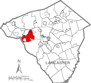
Conestoga Township is a township in west central Lancaster County, Pennsylvania, United States. At the 2020 census the population was 3,922.

<span class="mw-page-title-main">Conoy Township, Lancaster County, Pennsylvania</span> Township in Pennsylvania, United States

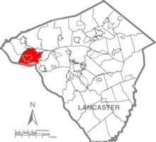
Conoy Township is a township in northwestern Lancaster County, Pennsylvania, United States. At the 2020 census, the population was 3,373.

<span class="mw-page-title-main">East Earl Township, Lancaster County, Pennsylvania</span> Township in Pennsylvania, United States

East Earl Township is a township in northeastern Lancaster County, Pennsylvania, United States. At the 2020 census, the population was 6,721.

<span class="mw-page-title-main">Fulton Township, Lancaster County, Pennsylvania</span> Township in Pennsylvania, United States

Fulton Township is a township in southern Lancaster County, Pennsylvania, United States, and it is the only municipality in the county to touch the Maryland border. At the 2020 census the population was 3,227. It is part of the Solanco School District.

<span class="mw-page-title-main">Athens Township, Bradford County, Pennsylvania</span> Township in Pennsylvania, United States

Athens Township is a township in Bradford County, Pennsylvania, United States. It is part of Northeastern Pennsylvania. The population was 5,198 at the 2020 census.

<span class="mw-page-title-main">Jackson Township, Dauphin County, Pennsylvania</span> Township in Pennsylvania, United States

Jackson Township is an American township that is located in Dauphin County, Pennsylvania. The population was 1,830 at the time of the 2020 census, a decline from the figure of 1,941 tabulated in 2010.

<span class="mw-page-title-main">Dublin Township, Fulton County, Pennsylvania</span> Township in Pennsylvania, United States

Dublin Township is a township in Fulton County, Pennsylvania, United States. The population was 1,199 at the 2020 census.

<span class="mw-page-title-main">Clay Township, Lancaster County, Pennsylvania</span> Township in Pennsylvania, United States

Clay Township is a township in north central Lancaster County, Pennsylvania, United States. The population was 6,887 at the 2020 census.

<span class="mw-page-title-main">Colerain Township, Lancaster County, Pennsylvania</span> Township in Pennsylvania, United States

Colerain Township is a township in southeastern Lancaster County, Pennsylvania, United States. The population was 3,883 at the 2020 census, an increase over the figure of 3,635 tabulated in 2010. It is part of the Solanco School District.

<span class="mw-page-title-main">Earl Township, Lancaster County, Pennsylvania</span> Township in Pennsylvania, United States

Earl Township is a township in northeastern Lancaster County, Pennsylvania, United States. The population was 7,149 at the 2020 census.

<span class="mw-page-title-main">Ephrata Township, Lancaster County, Pennsylvania</span> Township in Pennsylvania, United States

Ephrata Township is a township in northeastern Lancaster County, Pennsylvania, United States. The population was 10,391 at the 2020 census.

<span class="mw-page-title-main">Mount Joy Township, Lancaster County, Pennsylvania</span> Township in Pennsylvania, United States

Mount Joy Township is a township that is located in northwestern Lancaster County, Pennsylvania, United States. The population was 10,753 at the time of the 2020 census.

<span class="mw-page-title-main">Rapho Township, Pennsylvania</span> Township in Pennsylvania, United States

Rapho Township is a township that is located in northwestern Lancaster County, Pennsylvania, United States. The population was 12,058 at the time of the 2020 census.

<span class="mw-page-title-main">Strasburg Township, Pennsylvania</span> Township in Pennsylvania, United States

Strasburg Township is a township in south central Lancaster County, Pennsylvania, United States. The population was 4,467 at the 2020 census.

<span class="mw-page-title-main">West Donegal Township, Pennsylvania</span> Township in Pennsylvania, United States

West Donegal Township is a township in northwestern Lancaster County, Pennsylvania, United States. The population was 8,870 at the 2020 census.

<span class="mw-page-title-main">West Hempfield Township, Pennsylvania</span> Township in Pennsylvania, United States

West Hempfield Township is a township in west central Lancaster County, Pennsylvania, United States. The population was 17,061 at the 2020 census.

<span class="mw-page-title-main">Lafayette Township, McKean County, Pennsylvania</span> Township in Pennsylvania, United States

Lafayette Township is a township in McKean County, Pennsylvania, United States. The population was 1,863 at the 2020 census.

<span class="mw-page-title-main">Forks Township, Sullivan County, Pennsylvania</span> Township in Pennsylvania, United States

Forks Township is a township in Sullivan County, Pennsylvania, United States. The population was 372 at the 2020 census.

References

  1. "2016 U.S. Gazetteer Files". United States Census Bureau. Retrieved August 14, 2017.
  2. 1 2 3 4 Bureau, US Census. "City and Town Population Totals: 2020-2021". Census.gov. US Census Bureau. Retrieved July 9, 2022.
  3. "Early history". Reading Eagle. June 9, 1896. p. 25. Retrieved October 18, 2015.
  4. "National Register Information System". National Register of Historic Places . National Park Service. July 9, 2010.
  5. "About". January 19, 2012.
  6. "Census of Population and Housing". Census.gov. Retrieved June 4, 2016.
  7. "U.S. Census website". United States Census Bureau . Retrieved January 31, 2008.

40°03′30″N76°37′35″W / 40.05833°N 76.62639°W / 40.05833; -76.62639