Elizabeth Township, Lancaster County, Pennsylvania

Last updated
Elizabeth Township,
Lancaster County, Pennsylvania
Stiegel Coleman House LanCo PA.jpg
The Stiegel-Coleman House, a historic site in the township
Elizabeth Township, Lancaster County Highlighted.png
Map of Lancaster County highlighting Elizabeth Township
Country United States
State Pennsylvania
County Lancaster
Incorporated1757
Government
  TypeBoard of Supervisors
Area
[1]
  Total17.67 sq mi (45.77 km2)
  Land17.39 sq mi (45.04 km2)
  Water0.28 sq mi (0.73 km2)
Population
 (2020) [2]
  Total3,998 Increase2.svg
  Estimate 
(2021) [2]
3,983
  Density229.30/sq mi (88.53/km2)
Time zone UTC-5 (Eastern (EST))
  Summer (DST) UTC-4 (EDT)
Area code 717
FIPS code 42-071-23008
Website www.elizabethtownship.org

Elizabeth Township is a township in north central Lancaster County, Pennsylvania, United States. The population was 3,998 at the 2020 census. [2]

Contents

Geography

According to the United States Census Bureau, the township has a total area of 17.8 square miles (46 km2), of which 17.6 square miles (46 km2) is land and 0.2 square miles (0.52 km2) (1.07%) is water.

The township's largest village is Brickerville. Some other, smaller villages include: Elm, Poplar Grove, Spring Lake Park, Speedwell, and small portions of Halfville, Hopeland and Clay.

History

Elizabeth Township was established in 1757 as a split off Warwick Township. It was split again in 1853 to create the present Clay Township to the east.

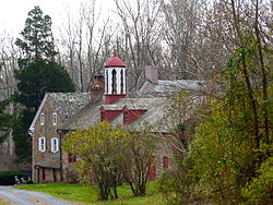
In early colonial days, the area now comprising Elizabeth Township played an important part in the development of the county. The village of Brickerville dates from 1741, when the area's first blast furnace was built to make cast iron from ore from the Cornwall mines. Stiegel glass manufacturing, dating from 1757, soon grew into an international export. Iron production grew, reaching its peak circa 1780 and continuing until 1856. The supplying of charcoal from area forests to feed the furnaces over this period became an important related industry.

The Hammer Creek Bridge, Stiegel-Coleman House, and Speedwell Forge are listed on the National Register of Historic Places. [3]

Demographics

Historical population
CensusPop.Note
2000 3,833
2010 3,8861.4%
2020 3,9982.9%
2021 (est.)3,983 [2] −0.4%
U.S. Decennial Census [4]

As of the census [5] of 2000, there were 3,833 people, 1,303 households, and 1,088 families living in the township. The population density was 218.0 people per square mile (84.2/km2). There were 1,334 housing units at an average density of 75.9/sq mi (29.3/km2). The racial makeup of the township was 98.62% White, 0.37% African American, 0.03% Native American, 0.29% Asian, 0.37% from other races, and 0.34% from two or more races. Hispanic or Latino of any race were 1.25% of the population.

There were 1,303 households, out of which 39.1% had children under the age of 18 living with them, 76.7% were married couples living together, 4.6% had a female householder with no husband present, and 16.5% were non-families. 12.7% of all households were made up of individuals, and 4.1% had someone living alone who was 65 years of age or older. The average household size was 2.94 and the average family size was 3.24.

In the township the population was spread out, with 29.5% under the age of 18, 7.9% from 18 to 24, 29.7% from 25 to 44, 24.9% from 45 to 64, and 8.0% who were 65 years of age or older. The median age was 36 years. For every 100 females there were 108.0 males. For every 100 females age 18 and over, there were 103.7 males.

The median income for a household in the township was $50,720, and the median income for a family was $54,181. Males had a median income of $39,074 versus $26,354 for females. The per capita income for the township was $19,078. About 2.5% of families and 4.4% of the population were below the poverty line, including 5.5% of those under age 18 and none of those age 65 or over.

Wolf Sanctuary of PA Wolf Sanctuary PA.jpg
Wolf Sanctuary of PA

Related Research Articles

<span class="mw-page-title-main">Manheim, Pennsylvania</span> Borough in Pennsylvania, United States

Manheim is a borough in Lancaster County, Pennsylvania, United States. The population was 5,064 at the 2020 census. The borough was named after Kerpen-Manheim, Germany.

<span class="mw-page-title-main">Brickerville, Pennsylvania</span> Census-designated place in Pennsylvania, United States

Brickerville is an unincorporated community and census-designated place (CDP) in Elizabeth Township, Lancaster County, Pennsylvania, United States, with a ZIP code of 17543. The population was 1,309 at the 2010 census.

<span class="mw-page-title-main">Eden Township, Lancaster County, Pennsylvania</span> Township in Pennsylvania, United States

Eden Township is a township in southeastern Lancaster County, Pennsylvania, United States. At the 2020 census, the population was 2,248. It is part of the Solanco School District.

<span class="mw-page-title-main">Highland Township, Adams County, Pennsylvania</span> Township in Pennsylvania, United States

Highland Township is a township in Adams County, Pennsylvania, United States, which was created in 1863 from parts of Hamiltonban, Cumberland, and Franklin townships.

<span class="mw-page-title-main">Cleveland Township, Columbia County, Pennsylvania</span> Township in Pennsylvania, United States

Cleveland Township is a township in Columbia County, Pennsylvania. It is part of Northeastern Pennsylvania. The population was 1,131 at the 2020 census.

<span class="mw-page-title-main">Lightstreet, Pennsylvania</span> Census-designated place in Pennsylvania, United States

Lightstreet is a census-designated place (CDP) in Columbia County, Pennsylvania, United States. It is part of Northeastern Pennsylvania. The population was 1,093 at the 2010 census. It is part of the Bloomsburg-Berwick micropolitan area. The CDP is named after a street in Baltimore.

<span class="mw-page-title-main">Main Township, Columbia County, Pennsylvania</span> Township in Pennsylvania, United States

Main Township is a township in Columbia County, Pennsylvania. It is part of Northeastern Pennsylvania. The population was 1,272 at the 2020 census. Main Township was settled in 1772 and incorporated in 1844. The iron industry was once preeminent in the township.

<span class="mw-page-title-main">Cooke Township, Cumberland County, Pennsylvania</span> Township in Pennsylvania, United States

Cooke Township is a township in Cumberland County, Pennsylvania, United States. The population was 179 at the 2010 census, up from 117 at the 2000 census.

<span class="mw-page-title-main">Black Lick Township, Indiana County, Pennsylvania</span> Township in Pennsylvania, United States

Black Lick Township is a township in Indiana County, Pennsylvania, United States. The population was 1,133 at the 2020 census. The township includes the communities of Grafton, Jacksonville, and Newport.

<span class="mw-page-title-main">Clay Township, Lancaster County, Pennsylvania</span> Township in Pennsylvania, United States

Clay Township is a township in north central Lancaster County, Pennsylvania, United States. The population was 6,887 at the 2020 census.

<span class="mw-page-title-main">Pequea Township, Lancaster County, Pennsylvania</span> Township in Pennsylvania, United States

Pequea Township is a township in central Lancaster County, Pennsylvania, United States. The population was 5,493 at the 2020 census. The community was named for the Piqua tribe.

<span class="mw-page-title-main">West Cocalico Township, Lancaster County, Pennsylvania</span> Township in Pennsylvania, United States

West Cocalico Township is a township in northeastern Lancaster County, Pennsylvania, United States. The population was 7,491 at the 2020 census.

<span class="mw-page-title-main">Wilmington Township, Lawrence County, Pennsylvania</span> Township in Pennsylvania, United States

Wilmington Township is a township in Lawrence County, Pennsylvania, United States. The population was 2,662 at the 2020 census, a decline from the figure of 2,715 tabulated in 2010.

<span class="mw-page-title-main">Jackson Township, Lebanon County, Pennsylvania</span> Township in Pennsylvania, United States

Jackson Township is an American township that is located in Lebanon County, Pennsylvania. The population was 9,352 at the time of the 2020 census.

<span class="mw-page-title-main">Hunlock Township, Luzerne County, Pennsylvania</span> Township in Pennsylvania, United States

Hunlock Township is a township in Luzerne County, Pennsylvania, United States. The population was 2,215 at the 2020 census.

<span class="mw-page-title-main">Jackson Township, Mercer County, Pennsylvania</span> Township in Pennsylvania, United States

Jackson Township is a township in Mercer County, Pennsylvania, United States. The population was 1,181 at the 2020 census, a decrease from the figure of 1,273 in 2010.

<span class="mw-page-title-main">Otter Creek Township, Mercer County, Pennsylvania</span> Township in Pennsylvania, United States

Otter Creek Township is a township in Mercer County, Pennsylvania, United States. The population was 525 at the 2020 census, down from 589 in 2010. Otter Creek Township received its name due to the creek's substantial otter population.

<span class="mw-page-title-main">Tyrone Township, Perry County, Pennsylvania</span> Township in Pennsylvania, United States

Tyrone Township is a township in Perry County, Pennsylvania, United States. The population was 1,905 at the 2020 census. The principal communities in the township are the villages of Green Park, Pennsylvania and Loysville. The township surrounds the borough of Landisburg.

<span class="mw-page-title-main">Pine Grove Township, Schuylkill County, Pennsylvania</span> Township in Pennsylvania, United States

Pine Grove Township is a township in Schuylkill County, Pennsylvania, United States. The population was 4,024 at the 2020 census.

<span class="mw-page-title-main">Peach Bottom Township, York County, Pennsylvania</span> Township in Pennsylvania, United States

Peach Bottom Township is a township in York County, Pennsylvania, 60 miles (97 km) south of Harrisburg. The population was 4,961 at the 2020 census.

References

  1. "2016 U.S. Gazetteer Files". United States Census Bureau. Retrieved Aug 14, 2017.
  2. 1 2 3 4 Bureau, US Census. "City and Town Population Totals: 2020-2021". Census.gov. US Census Bureau. Retrieved 9 July 2022.
  3. "National Register Information System". National Register of Historic Places . National Park Service. July 9, 2010.
  4. "Census of Population and Housing". Census.gov. Retrieved June 4, 2016.
  5. "U.S. Census website". United States Census Bureau . Retrieved 2008-01-31.

https://elizabethtownship.net/ Coordinates: 40°17′00″N76°17′59″W / 40.28333°N 76.29972°W / 40.28333; -76.29972