Churchtown, Pennsylvania | |
|---|---|
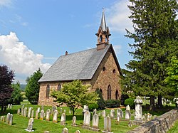 Bangor Episcopal Church | |
 Churchtown Location in Pennsylvania  Churchtown Location in the United States | |
| Coordinates: 40°7′59″N75°57′53″W / 40.13306°N 75.96472°W | |
| Country | United States |
| State | Pennsylvania |
| County | Lancaster |
| Township | Caernarvon |
| Area | |
• Total | 1.90 sq mi (4.92 km2) |
| • Land | 1.89 sq mi (4.88 km2) |
| • Water | 0.01 sq mi (0.04 km2) |
| Elevation | 564 ft (172 m) |
| Population | |
• Total | 417 |
| • Density | 221.22/sq mi (85.43/km2) |
| Time zone | UTC-5 (Eastern (EST)) |
| • Summer (DST) | UTC-4 (EDT) |
| ZIP code | 17555 |
| Area code | 717 |
| FIPS code | 42-13632 |
| GNIS feature ID | 1171873 [3] |
Churchtown is an unincorporated community and census-designated place (CDP) in Caernarvon Township, Lancaster County, Pennsylvania, United States, along Pennsylvania Route 23. The population was 470 as of the 2010 census. [4]


