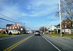
Hinkletown, Pennsylvania | |
---|---|
Coordinates: 40°8′53″N76°7′18″W / 40.14806°N 76.12167°W | |
Country | United States |
State | Pennsylvania |
County | Lancaster |
Township | Earl |
Elevation | 371 ft (113 m) |
Time zone | UTC-5 (Eastern (EST)) |
• Summer (DST) | UTC-4 (EDT) |
GNIS feature ID | 1177137 [1] |
Hinkletown is an unincorporated community located in Earl Township in Lancaster County, Pennsylvania, United States. Hinkletown is located along U.S. Route 322.
Pennsylvania, officially the Commonwealth of Pennsylvania,,, is a state spanning the Mid-Atlantic, Northeastern, Appalachian, and Great Lakes regions of the United States. Pennsylvania borders Delaware to its southeast, Maryland to its south, West Virginia to its southwest, Ohio to its west, Lake Erie and the Canadian province of Ontario to its northwest, New York to its north, and the Delaware River and New Jersey to its east.
The University of Pennsylvania is a private Ivy League research university in Philadelphia, Pennsylvania. It is one of nine colonial colleges and was chartered prior to the U.S. Declaration of Independence when Benjamin Franklin, the university's founder and first president, advocated for an educational institution that trained leaders in academia, commerce, and public service. Penn identifies as the fourth oldest institution of higher education in the United States, though this representation is challenged by other universities, as Franklin first convened the board of trustees in 1749, arguably making it the fifth oldest institution of higher education in the U.S.
Harrisburg is the capital city of the Commonwealth of Pennsylvania, United States, and the seat of Dauphin County. With a population of 50,135 as of 2021, Harrisburg is the 9th most populous city in Pennsylvania.
Bucks County is a county in the Commonwealth of Pennsylvania. As of the 2020 census, the population was 646,538, making it the fourth-most populous county in Pennsylvania. Its county seat is Doylestown. The county is named after the English county of Buckinghamshire.
State College is a home rule municipality in Centre County, Pennsylvania, United States. It is a college town, dominated economically, culturally, and demographically by the presence of the University Park campus of Penn State University.
Clearfield is a borough and the county seat of Clearfield County, Pennsylvania, United States. As of the 2020 census the population was 5,962 people, making it the second most populous community in Clearfield County, behind DuBois. The borough is part of the DuBois, PA Micropolitan Statistical Area, as well as the larger State College-DuBois, PA Combined Statistical Area. The settled area surrounding the borough consists of the nearby census-designated places of Hyde and Plymptonville, which combined with Clearfield have a population of approximately 8,237 people.
Earl Township is a township in northeastern Lancaster County, Pennsylvania, United States. The population was 7,149 at the 2020 census.
Ephrata Township is a township in northeastern Lancaster County, Pennsylvania, United States. The population was 10,391 at the 2020 census.
Penn Township is a township in Westmoreland County, Pennsylvania, United States.
The Pennsylvania State University is a public state-related land-grant research university with campuses and facilities throughout Pennsylvania. Founded in 1855 as Farmers' High School of Pennsylvania, in 1863, Penn State was named the state's first land-grant university. Its primary campus, known as Penn State University Park, is located in State College and College Township in Pennsylvania.
Pennsylvania Route 413 is a 31-mile-long (50 km), north–south state highway in Bucks County, Pennsylvania. The route runs from the New Jersey state line on the Burlington–Bristol Bridge over the Delaware River outside Bristol, where the road continues as Route 413 into New Jersey, north to PA 611 in Bedminster Township. The route passes through the lower and central portions of Bucks County, serving Bristol, Levittown, Langhorne, Newtown, and Buckingham. The route intersects U.S. Route 13 and Interstate 95 (I-95) near Bristol, I-295 near Penndel, US 1 in Langhorne Manor, and US 202 in Buckingham.
The Iowa Memorial Union, or IMU, at University of Iowa opened in 1925, the building currently houses a number of student clubs and the Iowa House Hotel.
The 2012 United States House of Representatives elections in Pennsylvania were held on Tuesday, November 6, 2012, to elect the 18 U.S. representatives from the state of Pennsylvania, a loss of one seat following the 2010 United States census. The elections coincided with the elections of other federal and state offices, including a quadrennial presidential election and an election to the U.S. Senate. Primary elections were held Tuesday, April 24.
The following is a list of former state routes in Pennsylvania. These roads are now either parts of other routes or no longer carry a traffic route number. This list also includes original routes of numbers that were decommissioned and later reactivated in other locations in which most of these are still active today.
Hinkletown was a small town in Keokuk County, Iowa during the nineteenth century.
White Pigeon was a town in Keokuk County, Iowa.
Hinkletown is a populated place situated in Plumstead Township in Bucks County, Pennsylvania, United States. It has an estimated elevation of 528 feet (161 m) above sea level.
The Pennsylvania State Game Lands Number 118 are Pennsylvania State Game Lands in Blair and Huntingdon counties in Pennsylvania in the United States, providing hunting, bird watching, and other activities.
The Pennsylvania State Game Lands Number 166 are Pennsylvania State Game Lands in Blair and Huntingdon Counties in Pennsylvania in the United States providing hunting, trapping, bird watching, and other activities.
The Pennsylvania State Game Lands Number 14 are Pennsylvania State Game Lands in Cameron, and Elk Counties in Pennsylvania in the United States providing hunting, bird watching, and other activities.