West Lampeter Township, Pennsylvania

Last updated

West Lampeter Township, Pennsylvania
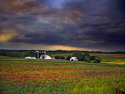
West Lampeter Farm.jpg
A farm in West Lampeter Township
West Lampeter Township, Lancaster County Highlighted.png
Map of Lancaster County, Pennsylvania highlighting West Lampeter Township
Map of Pennsylvania highlighting Lancaster County.svg
Map of Lancaster County, Pennsylvania
Country United States
State Pennsylvania
County Lancaster
Incorporated1841
Government
  TypeBoard of Supervisors
Area
[1]
  Total16.62 sq mi (43.04 km2)
  Land16.40 sq mi (42.47 km2)
  Water0.22 sq mi (0.57 km2)
Population
 (2020) [2]
  Total17,365 Increase2.svg
  Estimate 
(2021) [2]
17,394
  Density972.92/sq mi (375.64/km2)
Time zone UTC-5 (Eastern (EST))
  Summer (DST) UTC-4 (EDT)
Area code 717
FIPS code 42-071-83256
Website www.westlampeter.com

West Lampeter Township is a township that is located in central Lancaster County, Pennsylvania, United States. The population was 17,365 at the time of the 2020 census. [2]

Contents

History

The Johannes Harnish Farmstead, Christian and Emma Herr Farm, Hans Herr House, Lime Valley Covered Bridge, Neff's Mill Covered Bridge, Park Site, Rock Ford Plantation, and Weber-Weaver Farm are all located in this township and are all listed on the National Register of Historic Places. [3]

Geography

According to the United States Census Bureau, the township has a total area of 16.4 square miles (42.6 km2), all land.

The Conestoga River forms part of the northern boundary of the township, and Pequea Creek forms the southern boundary. The township is bordered to the north by the city of Lancaster and contains the unincorporated communities of Lyndon, Mylin Corners, Lampeter, Lime Valley, and part of Willow Street.

Demographics

Historical population
CensusPop.Note
2000 13,145
2010 15,20915.7%
2020 17,36514.2%
2021 (est.)17,394 [2] 0.2%
U.S. Decennial Census [4]

At the time of the 2000 census, there were 13,145 people, 5,284 households, and 3,762 families living in the township.

The population density was 800.0 inhabitants per square mile (308.9/km2). There were 5,467 housing units at an average density of 332.7 per square mile (128.5/km2).

The racial makeup of the township was 97.35% White, 0.79% African American, 0.05% Native American, 0.60% Asian, 0.01% Pacific Islander, 0.70% from other races, and 0.50% from two or more races. Hispanic or Latino of any race were 1.72%. [5]

There were 5,284 households; 27.6% had children who were under the age of eighteen living with them, 63.4% were married couples living together, 5.3% had a female householder with no husband present, and 28.8% were non-families. Out of all of the households that were documented, 26.1% were made up of individuals, and 17.8% had one person living alone who was aged sixty-five or older.

The average household size was 2.42 and the average family size was 2.91.

The age distribution was 22.5%of residents who were under the age of 18, 5.1% from 18 to 24, 24.3% from 25 to 44, 19.7% from 45 to 64, and 28.3% 65 or older. The median age was 44 years.

For every one hundred females, there were 87.5 males. For every one hundred females who were aged eighteen or older, there were 83.6 males.

The median household income was $51,043 and the median family income was $61,053. Males had a median income of $41,944 compared with that of $26,848 for females.

The per capita income for the township was $24,713.

Approximately 2.2% of families and 3.1% of the population were living below the poverty line, including 3.4% of those who were under the age of eighteen and 4.2% of those who were aged sixty-five or older.

Sports

ClubLeagueVenueEstablishedChampionships
Lancaster Liberty GPBL Basketball Student Life Center 2009 

Related Research Articles

<span class="mw-page-title-main">Willow Street, Pennsylvania</span> Census-designated place in Pennsylvania, United States

Willow Street is an unincorporated community and census-designated place (CDP) in Lancaster County, Pennsylvania, United States. The population was 7,578 at the 2010 census. In the early part of the 20th century, the main thoroughfare in town was lined with willow trees on both sides for the length of the town, hence the community's name. As time passed and the town grew, the road was widened and sidewalks were installed, which required the trees be removed. Only a few of the original trees remain to this day.

<span class="mw-page-title-main">East Hempfield Township, Pennsylvania</span> Township in Pennsylvania, United States

East Hempfield Township is a township in west-central Lancaster County, Pennsylvania, United States. At the 2020 census the population was 26,350.

<span class="mw-page-title-main">East Lampeter Township, Pennsylvania</span> Township in Pennsylvania, United States

East Lampeter Township is a township in central Lancaster County, Pennsylvania, United States. At the 2020 census, the population was 17,834.

<span class="mw-page-title-main">Menallen Township, Adams County, Pennsylvania</span> Township in Pennsylvania, United States

Menallen Township is a township that is located in Adams County, Pennsylvania, United States. The population was 3,515 at the time of the 2010 census.

<span class="mw-page-title-main">Worth Township, Butler County, Pennsylvania</span> Township in Pennsylvania, United States

Worth Township is a township that is located in Butler County, Pennsylvania, United States. The population was 1,398 at the time of the 2020 census.

<span class="mw-page-title-main">Graham Township, Clearfield County, Pennsylvania</span> Township in Pennsylvania, United States

Graham Township is a township in Clearfield County, Pennsylvania, United States. The population was 1,329 at the time of the 2020 census.

<span class="mw-page-title-main">Beaver Township, Columbia County, Pennsylvania</span> Township in Pennsylvania, United States

Beaver Township is a township in Columbia County, Pennsylvania. It is part of Northeastern Pennsylvania. The population was 879 at the 2020 census. Beaver Township is named for Beaver Run, a tributary of Catawissa Creek, both of which run through the township.

<span class="mw-page-title-main">Wayne Township, Greene County, Pennsylvania</span> Township in Pennsylvania, United States

Wayne Township is a township that is located in Greene County, Pennsylvania, United States. The population was 1,019 at the time of the 2020 census.

<span class="mw-page-title-main">Leacock Township, Pennsylvania</span> Township in Pennsylvania, United States

Leacock Township is an American township that is located in east central Lancaster County, Pennsylvania. As of the 2020 census, the population of the township was 5,652, an increase over the figure of 5,220 tabulated in 2010.

<span class="mw-page-title-main">Paradise Township, Lancaster County, Pennsylvania</span> Township in Pennsylvania, United States

Paradise Township is a township that is located in east-central Lancaster County, Pennsylvania, United States. The population was 5,696 at the time of the 2020 census.

<span class="mw-page-title-main">Penn Township, Lancaster County, Pennsylvania</span> Township in Pennsylvania, United States

Penn Township is a township that is located in north central Lancaster County, Pennsylvania, United States. The population was 10,224 at the time of the 2020 census.

<span class="mw-page-title-main">Pequea Township, Pennsylvania</span> Township in Pennsylvania, United States

Pequea Township is a township that is located in central Lancaster County, Pennsylvania, United States. The population was 5,493 at the time of the 2020 census.

<span class="mw-page-title-main">Providence Township, Lancaster County, Pennsylvania</span> Township in Pennsylvania, United States

Providence Township is a township that is located in south central Lancaster County, Pennsylvania, United States. The population was 7,025 at the time of the 2020 census.

<span class="mw-page-title-main">Rapho Township, Pennsylvania</span> Township in Pennsylvania, United States

Rapho Township is a township that is located in northwestern Lancaster County, Pennsylvania, United States. The population was 12,058 at the time of the 2020 census.

<span class="mw-page-title-main">Salisbury Township, Lancaster County, Pennsylvania</span> Township in Pennsylvania, United States

Salisbury Township is a township in east central Lancaster County, Pennsylvania, United States. The population was 11,531 at the 2020 census.

<span class="mw-page-title-main">West Cocalico Township, Pennsylvania</span> Township in Pennsylvania, United States

West Cocalico Township is a township that is located in northeastern Lancaster County, Pennsylvania, United States. The population was 7,491 at the time of the 2020 census.

<span class="mw-page-title-main">Liberty Township, McKean County, Pennsylvania</span> Township in Pennsylvania, United States

Liberty Township is a township in McKean County, Pennsylvania, United States. The population was 1,604 at the time of the census.

<span class="mw-page-title-main">Norwegian Township, Pennsylvania</span> Township in Pennsylvania, United States

Norwegian Township is a township that is located in Schuylkill County, Pennsylvania, United States. The population was 2,167 at the time of the 2020 census.

<span class="mw-page-title-main">Nelson Township, Pennsylvania</span> Township in Pennsylvania, United States

Nelson Township is a township in Tioga County, Pennsylvania, United States. The population was 545 at the 2020 census.

<span class="mw-page-title-main">Washington Township, York County, Pennsylvania</span> Township in Pennsylvania, United States

Washington Township is a township in York County, Pennsylvania, United States. The population was 2,576 at the 2020 census. Kralltown is one of the township's unincorporated communities.

References

  1. "2016 U.S. Gazetteer Files". United States Census Bureau. Retrieved August 14, 2017.
  2. 1 2 3 4 Bureau, US Census. "City and Town Population Totals: 2020-2021". Census.gov. US Census Bureau. Retrieved July 9, 2022.
  3. "National Register Information System". National Register of Historic Places . National Park Service. July 9, 2010.
  4. "Census of Population and Housing". Census.gov. Retrieved June 4, 2016.
  5. "U.S. Census website". United States Census Bureau . Retrieved January 31, 2008.

39°59′00″N76°13′59″W / 39.98333°N 76.23306°W / 39.98333; -76.23306