East Hempfield Township, Lancaster County, Pennsylvania

Last updated

East Hempfield Township,
Lancaster County, Pennsylvania
East Hempfield Township.jpg
A farm in East Hempfield Township
East Hempfield Township, Pennsylvania (town seal).png
East Hempfield Township, Lancaster County Highlighted.png
Map of Lancaster County highlighting East Hempfield Township
Country Flag of the United States.svg United States
State Flag of Pennsylvania.svg Pennsylvania
County Lancaster
Settled1717
Incorporated1818
Area
[1]
  Total21.16 sq mi (54.81 km2)
  Land21.07 sq mi (54.57 km2)
  Water0.09 sq mi (0.24 km2)
Population
 (2020) [2]
  Total26,350 Increase2.svg
  Estimate 
(2021) [2]
26,475
  Density1,156.54/sq mi (446.53/km2)
Time zone UTC-5 (Eastern (EST))
  Summer (DST) UTC-4 (EDT)
Area code 717
FIPS code 42-071-21232
Website www.easthempfield.org

East Hempfield Township is a township in west-central Lancaster County, Pennsylvania, United States. At the 2020 census the population was 26,350. [2]

Contents

East Hempfield is one of the six immediate suburbs of the city of Lancaster, all sharing the same official designation as Lancaster, Pennsylvania by the United States Postal Service. [3]

History

The Landis Mill Covered Bridge, Shenk's Mill Covered Bridge, Christian Habeck Farm, and Samuel N. Mumma Tobacco Warehouse are listed on the National Register of Historic Places. [4]

Geography

According to the U.S. Census Bureau, the township has a total area of 21.1 square miles (55 km2), all land. It includes the unincorporated communities of Mechanicsville, Landisville, Bamford, Centerville, Chestnut Ridge, Rohrerstown, Donerville, Chestnut View, and Wheatland, as well as part of Salunga.

Demographics

Historical population
CensusPop.Note
2000 21,399
2010 23,5229.9%
2020 26,35012.0%
2021 (est.)26,475 [2] 0.5%
U.S. Decennial Census [5]

As of the census [6] of 2000, there were 21,399 people, 8,552 households, and 6,054 families residing in the township. The population density was 1,011.6 inhabitants per square mile (390.6/km2). There were 8,761 housing units at an average density of 414.2 units per square mile (159.9 units/km2). The racial makeup of the township was 93.45% White, 1.51% Black or African American, 0.11% Native American, 2.56% Asian, 1.51% from other races, and 0.86% from two or more races. 2.78% of the population were Hispanic or Latino of any race.

There were 8,552 households, out of which 30.9% had children under the age of 18 living with them, 62.0% were married couples living together, 6.3% had a female householder with no husband present, and 29.2% were non-families. 24.1% of all households were made up of individuals, and 9.5% had someone living alone who was 65 years of age or older. The average household size was 2.47 and the average family size was 2.96.

In the township the population was spread out, with 23.9% under the age of 18, 6.7% from 18 to 24, 27.4% from 25 to 44, 26.7% from 45 to 64, and 15.4% who were 65 years of age or older. The median age was 41 years. For every 100 females, there were 96.2 males. For every 100 females age 18 and over, there were 93.6 males.

The median income for a household in the township was $54,431, and the median income for a family was $68,965. Males had a median income of $43,958 versus $29,496 for females. The per capita income for the township was $28,192. About 1.8% of families and 3.9% of the population were below the poverty line, including 4.1% of those under age 18 and 5.1% of those age 65 or over.

Points of interest

Notable person

Local businesses

Related Research Articles

<span class="mw-page-title-main">East Petersburg, Pennsylvania</span> Borough in Pennsylvania, United States

East Petersburg is a borough in Lancaster County, Pennsylvania, United States. The population was 4,591 at the 2020 census.

<span class="mw-page-title-main">Willow Street, Pennsylvania</span> Census-designated place in Pennsylvania, United States

Willow Street is an unincorporated community and census-designated place (CDP) in Lancaster County, Pennsylvania, United States. The population was 7,578 at the 2010 census. In the early part of the 20th century, the main thoroughfare in town was lined with willow trees on both sides for the length of the town, hence the community's name. As time passed and the town grew, the road was widened and sidewalks were installed, which required the trees be removed. Only a few of the original trees remain to this day.

<span class="mw-page-title-main">Conestoga Township, Lancaster County, Pennsylvania</span> Township in Pennsylvania, United States

Conestoga Township is a township in west central Lancaster County, Pennsylvania, United States. At the 2020 census the population was 3,922.

<span class="mw-page-title-main">Drumore Township, Lancaster County, Pennsylvania</span> Township in Pennsylvania, United States

Drumore Township is a township in southwestern Lancaster County, Pennsylvania, United States. At the 2020 census, the population was 2,568.

<span class="mw-page-title-main">East Donegal Township, Lancaster County, Pennsylvania</span> Township in Pennsylvania, United States

East Donegal Township is a township in northwestern Lancaster County, Pennsylvania, United States. At the 2020 census, the population was 8,690.

<span class="mw-page-title-main">East Lampeter Township, Lancaster County, Pennsylvania</span> Township in Pennsylvania, United States

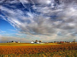
East Lampeter Township is a township in central Lancaster County, Pennsylvania, United States. At the 2020 census, the population was 17,834.

<span class="mw-page-title-main">Gulich Township, Clearfield County, Pennsylvania</span> Township in Pennsylvania, United States

Gulich Township is a township in Clearfield County, Pennsylvania, United States. The population was 1,204 at the 2020 census.

<span class="mw-page-title-main">Union Township, Clearfield County, Pennsylvania</span> Township in Pennsylvania, United States

Union Township is a township that is located in Clearfield County, Pennsylvania, United States. The population was 880 at the time of the 2020 census.

<span class="mw-page-title-main">Brecknock Township, Lancaster County, Pennsylvania</span> Township in Pennsylvania, United States

Brecknock Township is a township in northeastern Lancaster County, Pennsylvania, United States. The population was 7,585 at the 2020 census.

<span class="mw-page-title-main">Colerain Township, Lancaster County, Pennsylvania</span> Township in Pennsylvania, United States

Colerain Township is a township in southeastern Lancaster County, Pennsylvania, United States. The population was 3,883 at the 2020 census, an increase over the figure of 3,635 tabulated in 2010. It is part of the Solanco School District.

<span class="mw-page-title-main">Lancaster Township, Lancaster County, Pennsylvania</span> Township in Pennsylvania, United States

Lancaster Township is a civil township of Lancaster County, Pennsylvania, United States. It is in the central area of the county, and it immediately surrounds Lancaster City. As of the 2020 census, the township population was 18,591.

<span class="mw-page-title-main">Manheim Township, Lancaster County, Pennsylvania</span> Township in Pennsylvania, United States

Manheim Township is a township in Lancaster County, Pennsylvania, United States. It was established in 1729. The township's southernmost border meets the city limits of Lancaster. Its population, as of the 2020 census, was 44,012.

<span class="mw-page-title-main">Mountville, Pennsylvania</span> Borough in Pennsylvania, United States

Mountville is a borough in Lancaster County, Pennsylvania, United States. The population was 3,022 at the 2020 census, an increase over the figure of 2,802 tabulated in 2010. The original Charles Chips potato chip factory was located here.

<span class="mw-page-title-main">Salunga-Landisville, Pennsylvania</span> CDP in Pennsylvania, United States

Salunga-Landisville consists of two census-designated places (CDPs) in Lancaster County, Pennsylvania, United States with a zip code of 17538. As of the 2010 United States Census the population of Salunga CDP was 2,695 people and the population of Landisville CDP was 1,893 people for a combined total of 4,588, a decrease of about 3.8% from the 2000 United States Census which recorded 4,771 in the Salunga-Landisville CDP. The name "Salunga" comes from the nearby Chiquesalunga Creek, which in turn is derived from the Lenape "Chiquesalunga", meaning "place of the crayfish". Landisville is named for John Landis, the first postmaster there.

<span class="mw-page-title-main">West Hempfield Township, Lancaster County, Pennsylvania</span> Township in Pennsylvania, United States

West Hempfield Township is a township in west central Lancaster County, Pennsylvania, United States. The population was 17,061 at the 2020 census.

<span class="mw-page-title-main">West Lampeter Township, Lancaster County, Pennsylvania</span> Township in Pennsylvania, United States

West Lampeter Township is a township that is located in central Lancaster County, Pennsylvania, United States. The population was 17,365 at the time of the 2020 census.

<span class="mw-page-title-main">South Lebanon Township, Lebanon County, Pennsylvania</span> Township in Pennsylvania, United States

South Lebanon Township is a township in Lebanon County, Pennsylvania, United States. It is part of the Lebanon, PA Metropolitan Statistical Area. The population was 10,456 at the 2020 census.

<span class="mw-page-title-main">Pittsfield Township, Warren County, Pennsylvania</span> Township in Pennsylvania, United States

Pittsfield Township is a township in Warren County, Pennsylvania, United States. The population was 1,283 at the 2020 census, down from 1,405 at the 2010 census. 1,519 at the 2000 census.

<span class="mw-page-title-main">Hempfield Township, Westmoreland County, Pennsylvania</span> Township in Pennsylvania, United States

Hempfield Township is a township in Westmoreland County, Pennsylvania, United States. The population was 41,585 at the 2020 census, making it the largest suburb in the Pittsburgh Metropolitan Area by population. Its name is derived from Hempfield in Lancaster County, which was formed in 1729 and is named after the hemp fields in the area.

<span class="mw-page-title-main">Hallam, Pennsylvania</span> Borough in Pennsylvania, United States

HallamHEL-əm is a borough in York County, Pennsylvania, United States. The population was 2,774 at the 2020 census.

References

  1. "2016 U.S. Gazetteer Files". United States Census Bureau. Retrieved August 14, 2017.
  2. 1 2 3 4 Bureau, US Census. "City and Town Population Totals: 2020-2021". Census.gov. US Census Bureau. Retrieved July 9, 2022.
  3. Lancaster's suburbs. Penn State Press. ISBN   9780271045238 . Retrieved March 18, 2008 via Google.
  4. "National Register Information System". National Register of Historic Places . National Park Service. July 9, 2010.
  5. "Census of Population and Housing". Census.gov. Retrieved June 4, 2016.
  6. "U.S. Census website". United States Census Bureau . Retrieved January 31, 2008.

40°07′36″N76°22′28″W / 40.12667°N 76.37444°W / 40.12667; -76.37444