
Gisborne is a city in northeastern New Zealand and the largest settlement in the Gisborne District. It has a population of 37,700. The district council has its headquarters in Whataupoko, in the central city.

A system of counties of New Zealand was instituted after the country dissolved its provinces in 1876, and these counties were similar to other countries' systems, lasting with little change until 1989, when they were reorganised into district and city councils within a system of larger regions.

Tolaga Bay is both a bay and small town on the East Coast of New Zealand's North Island located 45 kilometres northeast of Gisborne and 30 kilometres south of Tokomaru Bay.

Te Aitanga-a-Hauiti is a Māori iwi (tribe) on the East Coast of New Zealand's North Island. Its rohe covers the area from Tawhiti-a-Paoa Tokomaru Bay to Te Toka-a-Taiau Gisborne on the East Coast of the North Island of New Zealand.

Gisborne District or the Gisborne Region is a local government area of northeastern New Zealand. It is governed by Gisborne District Council, a unitary authority. It is named after its largest settlement, the city of Gisborne. The region is also commonly referred to as the East Coast.
Waiapu was a New Zealand parliamentary electorate in the Gisborne – East Coast Region of New Zealand, from 1893 to 1908.

Wiremu "Wi" Pere, was a Māori Member of Parliament in New Zealand. He represented Eastern Māori in the House of Representatives from 1884 to 1887, and again from 1893 to 1905. Pere's strong criticism of the government's Māori land policies and his involvement in the turbulent land wars in the 1860s and 1870s made him a revered Māori leader and he was known throughout his career as an contentious debator and outstanding orator in the use of the Māori language.
Pātūtahi is a small settlement 15 kilometres from Gisborne, in the northeast of New Zealand's North Island. It is located in the valley of the Waipaoa River. From 1915 to 1931 Pātūtahi had a railway station on the Ngātapa Branch.

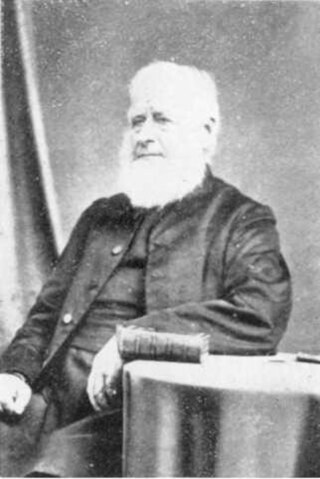
William Leonard Williams (1829–1916) was an Anglican bishop of Waiapu. He was regarded as an eminent scholar of the Māori language. His father, William Williams, was the first Bishop of Waiapu, Williams was the third bishop, and his son, Herbert Williams, was the sixth bishop of Waiapu.
William Williams was consecrated as the first Anglican Bishop of Waiapu, New Zealand, on 3 April 1859 by the General Synod at Wellington. His son, Leonard Williams became the third Bishop of Waiapu and his grandson, Herbert Williams, the sixth. His brother, the Rev. Henry Williams, led the Church Missionary Society (CMS) mission in New Zealand. William Williams led the CMS missionaries in translating the Bible into Māori and published an early dictionary and grammar of the Māori language.
Andrew Graham was a 19th-century Member of Parliament from the Gisborne Region of New Zealand.
Gisborne District Council is the unitary authority for the Gisborne District of New Zealand. The council consists of a mayor and 13 ward councillors. The district consists of the city of Gisborne and a largely rural region on the east coast of the North Island.
Te Kani-a-Takirau was a notable New Zealand tribal leader. Of Māori descent, he identified with Hapu Matua of the Te Aitanga A Hauiti Iwi. He was born in on the East Coast of New Zealand. He is well known for having refused to sign the Treaty of Waitangi in 1840.
Iharaira Te Houkamau (?–1875) was a notable New Zealand tribal leader. Of Māori descent, he identified with the Ngati Porou iwi.
Waipiro Bay is a small coastal settlement in the Gisborne District on the East Coast of the North Island of New Zealand. The name also refers to the bay that the settlement is built on. It was named Waipiro by Chief Paoa, which translates literally to "putrid water", referring to the area's sulphuric properties. It is in the Waiapu ward, along with nearby towns Te Puia Springs, Tokomaru Bay, and Ruatoria. It is located 15 km (9 mi) south of Ruatoria, 77 km (48 mi) north-east of Gisborne, and 41 km (25 mi) south-west of the East Cape Lighthouse, the easternmost point of mainland New Zealand. By road, it is 103 km (64 mi) from Gisborne, and 231 km (144 mi) from Ōpōtiki. Waipiro Bay is governed by the Gisborne District Council, and is in the East Coast electorate.

Waiapu Valley, also known as the Waiapu catchment, Waiapu River valley or simply Waiapu, is a valley in the north of the Gisborne Region on the East Coast of the North Island of New Zealand. It is the catchment area for the Waiapu River and its tributaries, and covers 1,734 square kilometres (670 sq mi). The Raukumara Range forms the western side of the valley, with Mount Hikurangi in the central west. The towns of Ruatoria and Tikitiki are in the north-east of the valley.
Waiapu County was one of the counties of New Zealand on the North Island.
Uawa County was one of the counties of New Zealand on the North Island. Today a part of the Gisborne Region, the county was constituted on 10 December 1918. The area had previously been a part of Cook County, and became a part of the county again when the two councils were amalgamated on 1 April 1964.
Matakaoa County was one of the counties of New Zealand in the North Island.
The Gisborne Region has a deep and complex history which dates back to the early 1300s. The region, on the East Coast of New Zealand's North Island, has many culturally and historically significant sites that relate to early Māori exploration in the 14th century and important colonial events, such as Captain Cook's first landfall in New Zealand.