
The Cenepa War or Third Ecuadorian-Peruvian War, also known as the Alto Cenepa War, was a brief and localized military conflict between Ecuador and Peru, fought over control of an area in Peruvian territory near the border between the two countries. The two nations had signed a border treaty following the Ecuadorian–Peruvian War of 1941, but Ecuador later disagreed with the treaty as it applied to the Cenepa and Paquisha areas, and in 1960 it declared the treaty null and void. Most of the fighting took place around the headwaters of the Cenepa River.
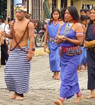
The Shuar, also known as Jivaro, are an indigenous ethnic group that inhabits the Ecuadorian and Peruvian Amazonia. They are famous for their hunting skills and their tradition of head shrinking, known as Tzantsa.

El Oro is the southernmost of Ecuador's coastal provinces. It was named for its historically important gold production. Today it is one of the world's major exporters of bananas. The capital is Machala.

Zamora Chinchipe, Province of Zamora Chinchipe is a province of the Republic of Ecuador, located at the southeastern end of the Amazon Basin, which shares borders with the Ecuadorian provinces of Azuay and Morona Santiago to the north, Loja and Azuay to the west, and with Peru to the east and south. The province comprises an area of approximately 10,559 km² and is covered with a uniquely mountainous topography which markedly distinguishes it from the surrounding Amazonian provinces. Zamora-Chinchipe is characterized and largely identified by its mining industry; indigenous ethnic groups with a rich archaeological legacy; its biodiversity; and its niche and tourist attractions, which include a number of waterfalls well-noted for their beauty. The province takes its name from the bureaucratic fusion of the Zamora and Chinchipe cantons. The provincial capital is the city of Zamora.

The Confederation of Indigenous Nationalities of Ecuador or, more commonly, CONAIE, is Ecuador's largest indigenous rights organization. The Ecuadorian Indian movement under the leadership of CONAIE is often cited as the best-organized and most influential Indigenous movement in Latin America.

The Paquisha War, Fake Paquisha War or Paquisha incident was a military clash that took place between January and February 1981 between Ecuador and Peru over the control of three watchposts. While Peru felt that the matter was already decided in the Ecuadorian–Peruvian War of 1941, Ecuador claimed that the Rio de Janeiro Protocol was not executable because a 78 km section of the border was not precisely defined.
The Cenepa River is a 185-kilometre (115 mi) stretch of river whose basin borders Ecuador and Peru, in the Cordillera del Cóndor mountain range in South America. Its drainage basin borders to the north on Ecuador, to the east on the districts of Río Santiago and Nieva in Peru, on the south with the district of Imaza, and on the west with Ecuador. The River has been subject to several border disputes between Peru and Ecuador; the most notable was the Cenepa War in 1995. The Awajún, the locals around the Cenepa River Basin, have had issues with the legal certainty of the River due to its cultural significance and resources. The Cenepa River has been impacted by the consequences of military action in the region through skirmishes between Ecuadorian and Peruvian forces along with the establishment of military camps and outposts. Expansion of local communities and the influence of mining have to different degrees interrupted the natural habitats of local fauna and flora. The Cenepa River has had government intervention through the growing recognition of the importance of preservation. This was a direct result of the peace talks that followed the Cenepa War in 1995, also known as the Alto Cenepa War.
The Chinchipe River is a river on the border between Ecuador and Peru. It rises in Ecuador, in the Zamora-Chinchipe Province, in the Podocarpus National Park. Then it flows through the Piura Region, and the Cajamarca Region in the San Ignacio Province of Peru. The river flows into the Maranon River.

The jocotoco antpitta is an endangered species of bird in the family Grallariidae. It is found in Ecuador and Peru.
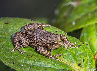
Nymphargus chancas is a species of frog in the family Centrolenidae. Until recently it was only known from its type locality in the Lamas Province in Peru; however, it is now known to occur more widely in the northern San Martín Region of Peru, extending into the Cordillera del Cóndor in Zamora-Chinchipe Province, Ecuador.
Hyloxalus shuar is a species of frog in the family Dendrobatidae. It is endemic to Ecuador and Peru and is currently known from only two locations, though formerly widespread. The common English-language names Santiago rocket frog and Shuar rocket frog have been proposed for it.
Pristimantis versicolor is a species of frog in the family Strabomantidae.
Pristimantis is a very large genus of frogs distributed in the southern Caribbean islands and in Central and South America from Honduras to northern Argentina and southern Brazil. With 596 described species, the genus had more species than any other genus of vertebrate animals. Many of these species genus are endemic to the Northwestern Andean montane forests ecoregion in north-western South America.
Mining in Ecuador was slow to develop in comparison to other Latin American countries, in spite of large mineral reserves. As late as 2012, according to the United Nations, Ecuador received less foreign direct investment per person than any other country in Latin America. During the 1980s, mining contributed only 0.7 percent to the Ecuadorian economy and employed around 7,000 people. Minerals were located in regions with little to no access, hindering exploration. Ecuador has reserves of gold, silver, copper, zinc, uranium, lead, sulfur, kaolin and limestone. The latter practically dominated the early industry as it was used in local cement plants.

Corriente Resources was a multinational corporation based in Canada that completed feasibility studies and environmental impact assessments (EIA) for open-pit copper mines in the Ecuadorian rainforest, including the Mirador mine. The Mirador mine is the first industrial scale copper mine to be developed in Ecuador. Corriente Resources also completed explorations of the San Carlos Panantza mine, although development of that project was halted in 2020 by Indigenous opposition.
The 2012 Ecuadorian protests were a series of demonstrations by indigenous peoples who oppose the copper mining concessions in the province of Zamora-Chinchipe. On 22 March, the protesters reached the capital Quito to be met with counter protesters and warnings from the government and President Rafael Correa.
The Mirador mine is a large copper mine located in the Amazonian province of Zamora-Chinchipe in southern Ecuador. It is one of the largest copper reserves in Ecuador, and the first industrial-scale copper project to be developed in the country. The project has generated an environmental conflict that is emblematic in the national political debate on mining.
The San Carlos Panantza mine is a large copper mine located in the south of Ecuador in Zamora-Chinchipe Province. San Carlos-Panantza is one of the largest copper reserves in Ecuador and in the world having estimated reserves of 600 million tonnes of ore grading 0.59% copper. The mine is in the Corriente copper belt along with the Mirador mine. It is being developed by ExplorCobres S.A., a subsidiary of the state-owned Chinese company CRCC-Tongguan Investment Co. Ltd that is also developing Mirador.
Shuaria is a genus of arborescent flowering plants belonging to the family Gesneriaceae. The genus is solely represented by Shuaria ecuadorica D.A.Neill & J.L.Clark, endemic to Ecuador. The generic name refers to the Shuar indigenous group of Amazonian Ecuador where several collections were made from the forests owned by the Shuar communities. Furthermore, the known range of S.ecuadorica corresponds quite closely to the ancestral Shuar territory in Pastaza, Morona-Santiago, and Chinchipe provinces.

Bracamoros is a region of numerous extinct tribal groups from the Ecuadorian and Peruvian Amazon rainforest, located in the watershed of the Zamora River.

