Coordinates: 37°53′43″N122°15′54″W / 37.89528°N 122.26500°W

A geographic coordinate system is a coordinate system that enables every location on Earth to be specified by a set of numbers, letters or symbols. The coordinates are often chosen such that one of the numbers represents a vertical position and two or three of the numbers represent a horizontal position; alternatively, a geographic position may be expressed in a combined three-dimensional Cartesian vector. A common choice of coordinates is latitude, longitude and elevation. To specify a location on a plane requires a map projection.
| Cragmont | |
|---|---|
| Neighborhood of Berkeley | |
 Cragmont Location within Berkeley and the East Bay | |
| Coordinates: 37°53′43″N122°15′54″W / 37.895278°N 122.265°W | |
| Country | United States |
| State | California |
| County | Alameda |
| City | Berkeley |
The Cragmont area of Berkeley is a residential district located in the northeastern section of the city, occupying most of the hill area north of Codornices Creek. It lies at an elevation of 755 feet (230 m).

Berkeley is a city on the east shore of San Francisco Bay in northern Alameda County, California. It is named after the 18th-century Irish bishop and philosopher George Berkeley. It borders the cities of Oakland and Emeryville to the south and the city of Albany and the unincorporated community of Kensington to the north. Its eastern border with Contra Costa County generally follows the ridge of the Berkeley Hills. The 2010 census recorded a population of 112,580.

Codornices Creek, 2.0 miles (3.2 km) long, is one of the principal creeks which runs out of the Berkeley Hills in the East Bay area of the San Francisco Bay Area in California. In its upper stretch, it passes entirely within the city limits of Berkeley, and marks the city limit with the adjacent city of Albany in its lower section. Before European settlement, Codornices probably had no direct, permanent connection to San Francisco Bay. Like many other small creeks, it filtered through what early maps show as grassland to a large, northward-running salt marsh and slough that also carried waters from Marin Creek and Schoolhouse Creek. A channel was cut through in the 19th Century, and Codornices flows directly to San Francisco Bay by way of a narrow remnant slough adjacent to Golden Gate Fields racetrack.
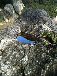
The Cragmont area was mostly grassland with oak and bay laurel trees in the canyons until the beginnings of the American era. The area was named for the various rock outcroppings which occur throughout the district. It was first developed as grazing land in the late 19th century. When a one-mile (1.6 km) exclusion zone for the sale of liquor was imposed with respect to the campus of the University of California, a local farmer opened up a saloon at what is now the corner of Spruce Street and Marin Avenue. Today, there are no commercial areas in the district.
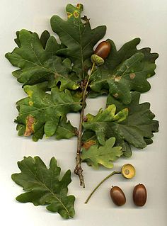
An oak is a tree or shrub in the genus Quercus of the beech family, Fagaceae. There are approximately 600 extant species of oaks. The common name "oak" also appears in the names of species in related genera, notably Lithocarpus, as well as in those of unrelated species such as Grevillea robusta and the Casuarinaceae (she-oaks). The genus Quercus is native to the Northern Hemisphere, and includes deciduous and evergreen species extending from cool temperate to tropical latitudes in the Americas, Asia, Europe, and North Africa. North America contains the largest number of oak species, with approximately 90 occurring in the United States, while Mexico has 160 species of which 109 are endemic. The second greatest center of oak diversity is China, which contains approximately 100 species.

The University of California (UC) is a public university system in the U.S. state of California. Under the California Master Plan for Higher Education, the University of California is a part of the state's three-system public higher education plan, which also includes the California State University system and the California Community Colleges System.
In the early 20th century, a streetcar line operated by the Key System was opened up along Euclid Avenue to Hilgard Street near the University campus. It was soon extended up Euclid as far as Regal Road, one block south of Marin Avenue. The area was immediately put up for sale for residential development.
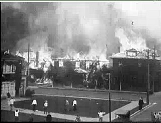
The Key System was a privately owned company that provided mass transit in the cities of Oakland, Berkeley, Alameda, Emeryville, Piedmont, San Leandro, Richmond, Albany, and El Cerrito in the eastern San Francisco Bay Area from 1903 until 1960, when it was sold to a newly formed public agency, AC Transit. The Key System consisted of local streetcar and bus lines in the East Bay, and commuter rail and bus lines connecting the East Bay to San Francisco by a ferry pier on San Francisco Bay, later via the lower deck of the Bay Bridge. At its height during the 1940s, the Key System had over 66 miles (106 km) of track. The local streetcars were discontinued in 1948 and the commuter trains to San Francisco were discontinued in 1958. The Key System's territory is today served by BART and AC Transit bus service.
Many homes in the Cragmont area command an outstanding view of San Francisco Bay and the Golden Gate. On the other hand, houses are closely spaced and there are many trees, posing a very high fire hazard during episodes of warm, dry and windy weather. There are also a number of active slides, and the Hayward Fault, a major branch of the San Andreas Fault, cuts right through the district, roughly along the alignment of (from south to north) La Loma-Euclid-Spruce streets.
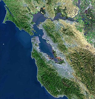
San Francisco Bay is a shallow estuary in the US state of California. It is surrounded by a contiguous region known as the San Francisco Bay Area, and is dominated by the large cities of San Jose, San Francisco and Oakland.

The Golden Gate is a strait on the west coast of North America that connects San Francisco Bay to the Pacific Ocean. It is defined by the headlands of the San Francisco Peninsula and the Marin Peninsula, and, since 1937, has been spanned by the Golden Gate Bridge. The entire shoreline and adjacent waters throughout the strait are managed by the Golden Gate National Recreation Area.

The San Andreas Fault is a continental transform fault that extends roughly 1,200 kilometers (750 mi) through California. It forms the tectonic boundary between the Pacific Plate and the North American Plate, and its motion is right-lateral strike-slip (horizontal). The fault divides into three segments, each with different characteristics and a different degree of earthquake risk. The slip rate along the fault ranges from 20 to 35 mm /yr.