The Arroyo Seco Parkway, also known as the Pasadena Freeway, is one of the oldest freeways built in the United States. The parkway connects Los Angeles with Pasadena alongside the Arroyo Seco seasonal river. It is notable not only for being an early freeway, mostly opened in 1940, but for representing the transitional phase between early parkways and later freeways. It conformed to modern standards when it was built, but is now regarded as a narrow, outdated roadway. A 1953 extension brought the south end to the Four Level Interchange in downtown Los Angeles and a connection with the rest of the freeway system.

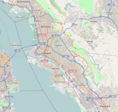
Telegraph Avenue is a street that begins, at its southernmost point, in the midst of the historic downtown district of Oakland, California, and ends, at its northernmost point, at the southern edge of the University of California, Berkeley campus in Berkeley, California. It is approximately 4.5 miles (7.2 km) in length.

Bernard Ralph Maybeck was an American architect in the Arts and Crafts Movement of the early 20th century. He worked primarily in the San Francisco Bay Area, designing public buildings, including the Palace of Fine Arts in San Francisco, and also private houses, especially in Berkeley, where he lived and taught at the University of California. A number of his works are listed on the National Register of Historic Places.
Fieldston is a privately owned affluent neighborhood in the Riverdale section of the northwestern part of the New York City borough of the Bronx. It is bounded by Manhattan College Parkway to the south, Henry Hudson Parkway to the west, 250th Street to the north, and Broadway to the east. It is noted for its rural atmosphere, large houses and abundance of trees. The majority of the neighborhood is included in the Fieldston Historic District, designated by the New York City Landmarks Preservation Commission in 2006.

The Olmsted Brothers company was a landscape architectural firm in the United States, established in 1898 by brothers John Charles Olmsted (1852–1920) and Frederick Law Olmsted Jr. (1870–1957), sons of the landscape architect Frederick Law Olmsted.

The Piedmont Avenue neighborhood is a residential and commercial district in the North Oakland region of Oakland, California. It is named for Piedmont Avenue, a commercial street known for dining and retail. The neighborhood is roughly bounded by Temescal and Broadway on the west, Oakland Avenue and the City of Piedmont on the east, the Mountain View Cemetery on the north, and the MacArthur Freeway section of Interstate 580 on the south.

State Route 83, also or primarily known as Euclid Avenue, is a state highway and city street in the U.S. state of California. Officially, SR 83 runs from the Chino Valley Freeway in Chino Hills north to the San Bernardino Freeway in Upland. Euclid Avenue then continues north through Upland to the unincorporated community of San Antonio Heights.

Commonwealth Avenue is a major street in the cities of Boston and Newton, Massachusetts. It begins at the western edge of the Boston Public Garden, and continues west through the neighborhoods of the Back Bay, Kenmore Square, Boston University, Allston, Brighton and Chestnut Hill. It continues as part of Route 30 through Newton until it crosses the Charles River at the border of the town of Weston.

Broad Street is a major arterial street in Philadelphia, Pennsylvania. The street runs for approximately 13 miles (21 km), beginning at the intersection of Cheltenham Avenue on the border of Cheltenham Township and the West/East Oak Lane neighborhoods of North Philadelphia to the Philadelphia Navy Yard in South Philadelphia. It is Pennsylvania Route 611 along its entire length with the exception of its northernmost part between Old York Road and Pennsylvania Route 309 and the southernmost part south of Interstate 95.
Delaware Park–Front Park System is a historic park system and national historic district in the northern and western sections of Buffalo in Erie County, New York. The park system was designed by Frederick Law Olmsted and Calvert Vaux and developed between 1868 and 1876.
The campus of the University of California, Berkeley, and its surrounding community are home to a number of notable buildings by early 20th-century campus architect John Galen Howard, his peer Bernard Maybeck, and their colleague Julia Morgan. Subsequent tenures as supervising architect held by George W. Kelham and Arthur Brown, Jr. saw the addition of several buildings in neoclassical and other revival styles, while the building boom after World War II introduced modernist buildings by architects such as Vernon DeMars, Joseph Esherick, John Carl Warnecke, Gardner Dailey, Anshen & Allen, and Skidmore, Owings and Merrill. Recent decades have seen additions including the postmodernist Haas School of Business by Charles Willard Moore, Soda Hall by Edward Larrabee Barnes, and the East Asian Library by Tod Williams Billie Tsien Architects.

Arborway consists of a four-lane, divided parkway and a two-lane residential street in the Jamaica Plain neighborhood of Boston, Massachusetts, United States. It was designed by Frederick Law Olmsted in the 1890s as the southern-most carriage road in a series of parkways connecting parks from Boston Common in downtown Boston to Franklin Park in Roxbury. This park system has since become known as the Emerald Necklace.

Fenway, commonly referred to as The Fenway, is a mostly one-way, one- to three-lane parkway that runs along the southern and eastern edges of the Back Bay Fens in the Fenway–Kenmore neighborhood of Boston, in the east-central part of the U.S. state of Massachusetts. As part of the Emerald Necklace park system mainly designed by Frederick Law Olmsted in the late 19th century, the Fenway, along with the Back Bay Fens and Park Drive, connects the Commonwealth Avenue Mall to the Riverway. For its entire length, the parkway travels along the Muddy River and is part of the Metropolitan Park System of Greater Boston. Like others in the park system, it is maintained by the Massachusetts Department of Conservation and Recreation.

The Old Fourth Ward, often abbreviated O4W, is an intown neighborhood on the eastside of Atlanta, Georgia, United States. The neighborhood is best known as the location of the Martin Luther King Jr. historic site.
Southside, also known by the older names South of Campus or South Campus, is a neighborhood in Berkeley, California. Southside is located directly south of and adjacent to the University of California, Berkeley campus. Because of the large student presence in the neighborhood, proximity to Sproul Plaza, and history of the area, Southside is the neighborhood most closely associated with the university.
The Elmwood District is a neighborhood of the City of Berkeley, California. It is primarily residential, with a small commercial area. The district does not have set lines of demarcation, but is focused around College and Ashby Avenues. The most extreme definitions of the district's boundaries do not extend past Telegraph Avenue to the west, Dwight Way to the north, or the Oakland city limit to the south. Elmwood was a streetcar suburb that was developed in the 1900s housing boom following the 1906 San Francisco earthquake, and was the first Berkeley subdivision to be assigned single-family residential zoning.

Furnace Brook Parkway is a historic parkway in Quincy, Massachusetts. Part of the Metropolitan Park System of Greater Boston, it serves as a connector between the Blue Hills Reservation and Quincy Shore Reservation at Quincy Bay. First conceived in the late nineteenth century, the state parkway is owned and maintained by the Massachusetts Department of Conservation and Recreation (DCR) and travels through land formerly owned by the families of John Adams and John Quincy Adams, passing several historic sites. It ends in the Merrymount neighborhood, where Quincy was first settled by Europeans in 1625 by Captain Richard Wollaston. The road was started in 1904, completed in 1916 and added to the National Register of Historic Places (NRHP) in 2004.

Park Drive is a mostly one-way, two-lane parkway in the Fenway-Kenmore neighborhood of Boston that runs along the northern and western edges of the Back Bay Fens before ending at Mountfort Street. As part of the Emerald Necklace park system mainly designed by Frederick Law Olmsted in the late 19th century, Park Drive, along with the Back Bay Fens and the Fenway, connects the Commonwealth Avenue Mall and Boylston Street to Beacon Street and the Riverway. For a portion of its length, the parkway runs along the Muddy River and is part of the Metropolitan Park System of Greater Boston's Muddy River Reservation. Like others in the park system, it is maintained by the Massachusetts Department of Conservation and Recreation.

Panoramic Hill is a residential neighborhood of the cities of Berkeley and Oakland, California defined by the homes along and within the access corridor defined by Panoramic Way.