
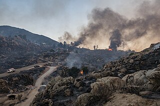
The Oakland firestorm of 1991 was a large suburban wildland–urban interface conflagration that occurred on the hillsides of northern Oakland, California, and southeastern Berkeley over the weekend of October 19–20, 1991, before being brought under full control on October 23. The official name of this incident by Cal Fire is the Tunnel Fire. It is also commonly referred to as the Oakland Hills firestorm or the East Bay Hills fire. The fire ultimately killed 25 people and injured 150 others. The 1,520 acres destroyed included 2,843 single-family dwellings and 437 apartment and condominium units. The economic loss from the fire was estimated at $1.5 billion.
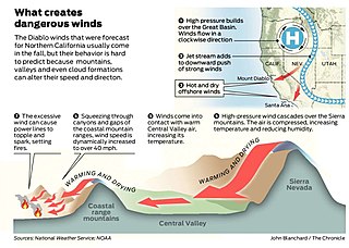
Diablo wind is a name that has been occasionally used for the hot, dry wind from the northeast that typically occurs in the San Francisco Bay Area of Northern California during the spring and fall.

A fireboat or fire-float is a specialized watercraft with pumps and nozzles designed for fighting shoreline and shipboard fires. The first fireboats, dating to the late 18th century, were tugboats, retrofitted with firefighting equipment. Older designs derived from tugboats and modern fireboats more closely resembling seafaring ships can both be found in service today. Some departments would give their multi-purpose craft the title of "fireboat" also.

Bernard Ralph Maybeck was an American architect. He worked primarily in the San Francisco Bay Area, designing public buildings, including the Palace of Fine Arts in San Francisco, and also private houses, especially in Berkeley, where he lived and taught at the University of California. A number of his works are listed on the National Register of Historic Places.
The Cedar Fire was a massive, highly-destructive wildfire, which burned 273,246 acres (1,106 km2) of land in San Diego County, California, during October and November 2003. The fire's rapid growth was driven by the Santa Ana winds, causing the fire to spread at a rate of 3,600 acres (15 km2) per hour. By the time the fire was fully contained on November 4, it had destroyed 2,820 buildings and killed 15 people, including one firefighter. Hotspots continued to burn within the Cedar Fire's perimeter until December 5, 2003, when the fire was fully brought under control.

A firebreak or double track is a gap in vegetation or other combustible material that acts as a barrier to slow or stop the progress of a bushfire or wildfire. A firebreak may occur naturally where there is an absence of vegetation or "fuel", such as a river, lake or canyon. Firebreaks may also be man-made, and many of these also serve as roads, such as logging roads, four-wheel drive trails, secondary roads, or highways.

Northside is a principally residential neighborhood in Berkeley, California, located north of the University of California, Berkeley campus, east of Oxford Street, and south of Cedar Street. There is a small shopping area located at Euclid and Hearst Avenues, at the northern entrance to the university. The Graduate Theological Union is located one block west of Euclid Avenue, in an area nicknamed Holy Hill. The north fork of Strawberry Creek runs southwestward across Northside, mostly culverted under buildings and pavement, to the campus.

The Berkeley Hills are a range of the Pacific Coast Ranges, and overlook the northeast side of the valley that encompasses San Francisco Bay. They were previously called the "Contra Costa Range/Hills", but with the establishment of Berkeley and the University of California, the name was updated by geographers and gazetteers.
Grizzly Peak is a summit in the Berkeley Hills above Berkeley, California. The peak is located on the border between Alameda and Contra Costa counties, within the boundaries of Tilden Regional Park, and directly behind the University of California, Berkeley campus.

Codornices Creek, 2.0 miles (3.2 km) long, is one of the principal creeks which runs out of the Berkeley Hills in the East Bay area of the San Francisco Bay Area in California. In its upper stretch, it passes entirely within the city limits of Berkeley, and marks the city limit with the adjacent city of Albany in its lower section. Before European settlement, Codornices probably had no direct, permanent connection to San Francisco Bay. Like many other small creeks, it filtered through what early maps show as grassland to a large, northward-running salt marsh and slough that also carried waters from Marin Creek and Schoolhouse Creek. A channel was cut through in the 19th century, and Codornices flows directly to San Francisco Bay by way of a narrow remnant slough adjacent to Golden Gate Fields racetrack.

Downtown Berkeley is the central business district of the city of Berkeley, California, United States, around the intersection of Shattuck Avenue and Center Street, and extending north to Hearst Avenue, south to Dwight Way, west to Martin Luther King Jr. Way, and east to Oxford Street. Downtown is the mass transit hub of Berkeley, with several AC Transit and UC Berkeley bus lines converging on the city's busiest BART station, as well as the location of Berkeley's civic center, high school, and Berkeley City College.

The Gourmet Ghetto is a colloquial name for the business district of the North Berkeley neighborhood in the city of Berkeley, California, known as the birthplace of California cuisine. Other developments that can be traced to this neighborhood include specialty coffee, the farm-to-table and local food movements, the rise to popularity in the U.S. of chocolate truffles and baguettes, the popularization of the premium restaurant designed around an open kitchen, and the California pizza made with local produce. After coalescing in the mid-1970s as a culinary destination, the neighborhood received its "Gourmet Ghetto" nickname in the late 1970s from comedian Darryl Henriques. Early, founding influences were Peet's Coffee, Chez Panisse and the Cheese Board Collective. Alice Medrich began her chain of Cocolat chocolate stores there.
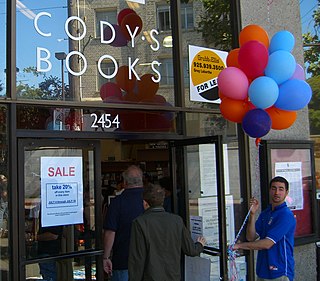
Cody's Books (1956–2008) was an independent bookstore based in Berkeley, California. It "was a pioneer in bookselling, bringing the paperback revolution to Berkeley, fighting censorship, and providing a safe harbor from tear gas directed at anti-Vietnam War protesters throughout the 1960s and 1970s."
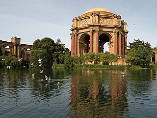
The Marina District is a neighborhood located in San Francisco, California. The neighborhood sits on the site of the 1915 Panama–Pacific International Exposition, staged after the 1906 San Francisco earthquake to celebrate the reemergence of the city. Aside from the Palace of Fine Arts, all other buildings were demolished to make the current neighborhood.
The Sesnon Fire was a wildfire that broke out near the oil fields of Oat Mountain, north of Porter Ranch, California, on Monday October 13, 2008. The cause of this fire was a power line falling onto dry brush near a drainage area. A state of emergency was declared by Governor Arnold Schwarzenegger on October 13 in Los Angeles and Ventura Counties. The fire burned more than 22 square miles (57 km2) and cost US$7.9 million to fight. This fire occurred concurrently two others, one in San Diego County and another at the eastern end of the San Fernando Valley. One person lost their life due to the low visibility on highways because of the smoke from the fire.
The Chicago Fire of 1874 took place on July 14. Reports of the extent of the damage vary somewhat, but sources generally agree that the fire burned 47 acres (19 ha) just south of the Loop, destroyed 812 structures and killed 20 people. The affected neighborhood had been home to Chicago's community of Jewish immigrants from Russia and Poland, as well as to a significant population of middle-class African-American families; both ethnic groups were displaced in the aftermath of the fire to other neighborhoods on the city's West and South Sides.

The Fawn Fire was a destructive wildfire in Northern California's Shasta County, near Redding, in late September and early October 2021. The fire, which was caused by an alleged act of arson, ignited on September 22 in mountains to the northeast of Redding. High winds the following day drove the fire south and west into neighborhoods in the wildland-urban interface, where it destroyed 185 buildings and damaged 26 more. At least three firefighters were injured. The Fawn Fire cost more than $25 million to suppress and burned 8,578 acres before being fully contained on October 2. A woman was arrested the day of the Fawn Fire's ignition and charged with starting the fire. As of 2024, legal proceedings remained ongoing.
The Fairview Fire is a deadly and destructive wildfire that burned during the 2022 California wildfire season southwest of Valle Vista and east of Hemet in Riverside County, California in the United States. The fire ignited on September 5, 2022, during a severe heatwave that had plagued much of the southwest throughout early September and, due to the extreme weather conditions, grew to a deadly and destructive conflagration in the chaparral-filled foothills within just several hours of igniting.

The 1992 Fountain Fire was a large and destructive wildfire in Shasta County, California. The fire ignited on August 20 in an act of probable but unattributed arson, and was quickly driven northeast by strong winds. It outpaced firefighters for two days, exhibiting extreme behavior such as long-range spot fires, crown fire runs, and pyrocumulonimbus clouds with dry lightning. The fire was contained after burning for nine days, though work to strengthen and repair fire lines continued for more than two months.

