
Larder Lake is an incorporated municipal township and eponymous constituent dispersed rural community in Timiskaming District in Northeastern Ontario, Canada. It is located along Ontario Highway 66 and Ontario Highway 624 at the north-western part of the lake bearing the same name. The area of the township is 229.65 km2 (88.67 sq mi) and includes the geographic townships of Hearst, McVittie and Skead.
Marmora and Lake is a municipality along the banks of Crowe River and Beaver Creek, about midway between Toronto and Ottawa on provincial Highway 7 in Hastings County in Central Ontario, Canada. It is home to over 4,000 full time and seasonal residents, many of whom enjoy outdoor recreation and relaxation on Crowe Lake.

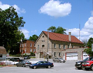
The Municipality of Trent Hills is a township municipality in Northumberland County in Central Ontario, Canada. It is on the Trent River and was created in 2001 through the amalgamation of the municipalities of Campbellford/Seymour, Percy Township and Hastings. Thereafter it was known in brief as Campbellford/Seymour, Percy, Hastings.

Kaladar is a compact rural community and unincorporated area in the municipality of Addington Highlands, Lennox and Addington County in Eastern Ontario, Canada. It is located at the junction of Ontario Highway 7 and Ontario Highway 41.
Cooper's Falls is a Dispersed rural community and unincorporated place in geographic Rama Township in the municipality of Ramara, Simcoe County, in Central Ontario, Canada. The community is located at the eponymous Coopers Falls waterfall on the Black River, about 5 kilometres (3.1 mi) northeast of the community of Washago on Ontario Highway 11, and is named after Thomas Cooper, the first settler. There are a few families living in Coopers Falls.
The Clyde River is a river in Lanark County in Eastern Ontario, Canada. It is in the Saint Lawrence River drainage basin, is a left tributary of the Mississippi River, and was named after the River Clyde in Scotland.

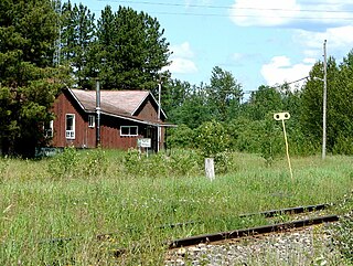
Latchford is a single-tier municipality town in Timiskaming District in Northeastern Ontario, Canada. It is located on Bay Lake on the Montreal River, near the town of Cobalt and the municipality of Temagami, and is 20 kilometres from the city of Temiskaming Shores. The population of the town in the Canada 2011 Census was 387, which makes it the smallest town by population in Ontario. The town's slogan is "The Best Little Town by a Dam Site!"

Greater Madawaska is an incorporated township in Renfrew County in eastern Ontario, Canada, created on January 1, 2001, through the amalgamation of the Township of Bagot and Blythfield, the Township of Brougham, and the Township of Griffith and Matawatchan. As of 2021, it has a population of 2,864.

Lac-Sainte-Thérèse is a dispersed rural community in geographic Casgrain Township, Cochrane District in Northeastern Ontario, Canada. The community is counted as part of Unorganized Cochrane North Part in Canadian census data.

James is an incorporated township in the Canadian province of Ontario, located in Timiskaming District. The primary community within the township is Elk Lake, which is located at the junction of Ontario Highway 65 and Ontario Highway 560.

Jogues is a dispersed rural community and unincorporated place in geographic Way Township, Cochrane District in Northeastern Ontario, Canada. It is about 11 kilometres (6.8 mi) southwest of Hearst. Jogues is also a designated place served by a local services board.

Coppell is a dispersed rural community and unincorporated place in geographic Lowther Township, Cochrane District in Northeastern Ontario, Canada. It is about 22 kilometres (14 mi) southwest of Hearst, and is counted as part of Unorganized Cochrane North Part in Canadian census data.
Mead is a Dispersed Rural Community and unincorporated place in geographic Lowther Township, Cochrane District in Northeastern Ontario, Canada. The community is counted as part of Unorganized Cochrane North Part in Canadian census data, and is located just north of the border with Algoma District.

Queensborough is an unincorporated community in the municipality of Tweed, Hastings County, in Central Ontario, Canada. It is located north of Ontario Highway 7 on the Black River, about 20 kilometres (12 mi) north-west of the village of Tweed and 15 kilometres (9.3 mi) north-east of the town of Madoc.

The Blanche River is a river in the Saint Lawrence River drainage basin in Timiskaming District in northeastern Ontario, Canada. The river is a tributary of Lake Timiskaming and its name is from the French for the colour "white".
Black Donald Lake is a reservoir lake in the Township of Greater Madawaska, Renfrew County, and the Township of North Frontenac, Frontenac County, in Eastern Ontario, Canada. It is on the Madawaska River and is part of the Saint Lawrence River drainage basin.

Centennial Lake is a reservoir lake in the Township of Greater Madawaska, Renfrew County, and the Township of North Frontenac, Frontenac County, in Eastern Ontario, Canada. It is on the Madawaska River and is part of the Saint Lawrence River drainage basin.
Marina Veilleux is a marina and unincorporated locality in geographic Hanlan Township, Cochrane District in Northeastern Ontario, Canada. The community is counted as part of Unorganized Cochrane North Part in Canadian census data, and is located on Lac Pivabiska about 13 kilometres (8.1 mi) north northwest of Hearst. It serves as a jumping off point for travel on the lake.
Fontaine's Landing is an unincorporated area in geographic Hanlan Township, Cochrane District in Northeastern Ontario, Canada. The community is counted as part of Unorganized Cochrane North Part in Canadian census data, and is located at the southwest corner of Wolverine Lake where the Valentine River enters the lake, about 15 kilometres (9.3 mi) northwest of Hearst.

Silver Lake is a lake in Tay Valley, Lanark County, and Central Frontenac, Frontenac County, in Eastern Ontario, Canada. It is the source of Silver Lake Creek and is in the Ottawa River drainage basin.

