Crawley Borough Council

Last updated
Crawley Borough Council
Crawley Borough Council logo.jpg
Type
Type
Leadership
Sharmila Sivarajah,
Labour
since 24 May 2024 [1]
Michael Jones,
Labour
since 27 May 2022 [2]
Ian Duke
since 25 September 2023 [3]
Structure
Seats36 councillors
UK Crawley Borough Council 2023.svg
Political groups
Administration (25)
  Labour (25)
Opposition (11)
  Conservative (11)
Length of term
4 years
Elections
Last election
2 May 2024
Next election
7 May 2026
Meeting place
New Town Hall, Crawley.jpg
Town Hall, The Boulevard, Crawley, RH10 0ZZ
Website
crawley.gov.uk

Crawley Borough Council is the local authority for Crawley in West Sussex, England. It consists of 36 councillors and is currently controlled by the Labour Party, led by Michael Jones. The administrative headquarters are at Crawley Town Hall.

Contents

History

Prior to 1956 Crawley had been governed as a rural parish within the Horsham Rural District. The parish was significantly enlarged in 1933 when the neighbouring parish of Ifield was abolished. Following the designation of Crawley as a new town in 1947, [4] the parish was further enlarged in 1953 to take in the Three Bridges area from the neighbouring parish of Worth. [5]

The parish of Crawley was made an urban district in 1956. [6] [7]

The urban district was reconstituted as a non-metropolitan district on 1 April 1974 under the Local Government Act 1972, gaining the parts of the parishes of Slaugham and Worth within the designated area for the new town, plus Gatwick Airport and adjoining areas from the Surrey parishes of Charlwood and Horley. [8] [9] The reformed district was awarded borough status at the same time, allowing the chair of the council to take the title of mayor. [10]

Governance

Crawley Borough Council provides district-level services. County-level services are provided by West Sussex County Council. [11] There are no civil parishes in the borough, which is an unparished area. [12]

Political control

The council has been under Labour majority control since 2022. [13]

Political control of the council since the 1974 reforms has been as follows: [14] [15]

Party in controlYears
Labour 1974–2006
Conservative 2006–2006
No overall control 2006–2007
Conservative 2007–2014
Labour 2014–2020
No overall control 2020–2022
Labour 2022–present

Leadership

The role of mayor is largely ceremonial in Crawley. Political leadership is instead provided by the leader of the council. The leaders since 1974 have been: [16]

CouncillorPartyFromTo
George Waller Labour 19741978
Ben Clay Labour 19781980
Alf Pegler Labour 19801982
Tony Edwards Labour 19821983
Ben Clay Labour 19831986
Alf Pegler Labour 19861996
Tony Edwards Labour 19962000
Chris Redmayne Labour 20002006
Bob Lanzer Conservative 20062013
Howard Bloom Conservative 20132014
Peter Lamb Labour 20142022
Michael Jones Labour 2022

Composition

Following the 2024 election, the composition of the council was: [17] [18]

PartyCouncillors
Labour 25
Conservative 11
Total36

The next election is due in 2026.

Elections

Since the last boundary changes in 2019 the council has comprised 36 councillors representing 13 wards. Each ward elects two or three councillors. Elections are held three years out of every four, with a third of the council being elected each time for a four-year term of office. West Sussex County Council elections are held in the fourth year of the cycle when there are no borough council elections. [19]

Premises

Old Town Hall: Council's headquarters 1964-2022 Crawley Town Hall 01.JPG
Old Town Hall: Council's headquarters 1964–2022

The council is based at Crawley Town Hall on the Boulevard, purpose-built for it on the site of the old Civic Hall (in the Town Hall complex built in 1964 for the urban district council) and formally opened on 21 March 2023. [20] [21] [22]

Related Research Articles

<span class="mw-page-title-main">Reigate and Banstead</span> Borough and non-metropolitan district in England

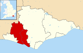
Reigate and Banstead is a local government district with borough status in Surrey, England. Its council is based in Reigate and the borough also includes the towns of Banstead, Horley and Redhill. Parts of the borough are within the Surrey Hills, a designated Area of Outstanding Natural Beauty. Northern parts of the borough, including Banstead, lie inside the M25 motorway which encircles London.

<span class="mw-page-title-main">Mid Sussex District</span> Non-metropolitan district in England

Mid Sussex is a local government district in West Sussex, England. The largest town is Haywards Heath, where the council is based. The district also contains the towns of Burgess Hill and East Grinstead plus surrounding rural areas, including many villages. The district includes part of the South Downs National Park and part of the designated Area of Outstanding Natural Beauty of High Weald, including sections of Ashdown Forest. The district contains most headwaters of the River Ouse. Its largest body of water is Ardingly reservoir which is used by watersports clubs. At the 2021 census the district had a population of 152,949.

<span class="mw-page-title-main">Nuneaton and Bedworth</span> Borough & Non-metropolitan district in England

Nuneaton and Bedworth is a local government district with borough status in Warwickshire, England. It includes the towns of Nuneaton and Bedworth, as well as a modest rural hinterland including the village of Bulkington.

<span class="mw-page-title-main">South Ribble</span> Borough and non-metropolitan district in England

South Ribble is a local government district with borough status in Lancashire, England. Its council is based in Leyland. The borough also includes the towns and villages of Penwortham, Leyland, Farington, Hutton, Longton, Walmer Bridge, Salmesbury, Lostock Hall, Walton le Dale and Bamber Bridge. Many of the built-up areas in the borough form part of the wider Preston built-up area.

<span class="mw-page-title-main">Mole Valley</span> Non-metropolitan district in England

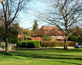
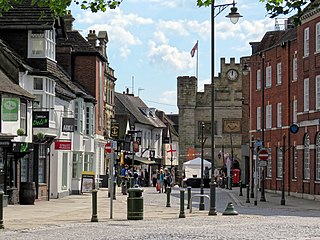
Mole Valley is a local government district in Surrey, England. Its council is based in Dorking, and the district's other town is Leatherhead. The largest villages are Ashtead, Fetcham and Great Bookham, in the northern third of the district.

<span class="mw-page-title-main">Tandridge District</span> Non-metropolitan district in England

Tandridge is a local government district in east Surrey, England. Its council is based in Oxted, although the largest settlement is Caterham; other notable settlements include Warlingham, Godstone and Lingfield. In mid-2019, the district had an estimated population of 88,129.

<span class="mw-page-title-main">Lewes District</span> Non-metropolitan district in England

Lewes is a local government district in East Sussex, England. The district is named after the town of Lewes. The largest town is Seaford. The district also includes the towns of Newhaven, Peacehaven and Telscombe and numerous villages and surrounding rural areas. The council meets in Lewes and has its main offices in Newhaven.

<span class="mw-page-title-main">Horsham District</span> Local government district in West Sussex, England

Horsham is a local government district in West Sussex, England. It is named after the town of Horsham, which is its largest settlement and where the council is based. The district also includes the surrounding rural area and contains many villages, the largest of which are Southwater and Billingshurst. The district includes part of the South Downs National Park and part of the designated Area of Outstanding Natural Beauty of High Weald. At the 2021 census the district had a population of 147,487.

<span class="mw-page-title-main">Borough of Great Yarmouth</span> Non-metropolitan district and borough in England

The Borough of Great Yarmouth is a local government district with borough status in Norfolk, England. It is named after its main town, Great Yarmouth, and also contains the town of Gorleston-on-Sea and a number of villages and rural areas, including part of The Broads. Other notable settlements include Caister-on-Sea, Hemsby, Hopton-on-Sea and Winterton-on-Sea.

<span class="mw-page-title-main">Mansfield District</span> Non-metropolitan district in England

Mansfield District is a local government district in Nottinghamshire, England. It is named after the town of Mansfield, where the council is based. The district also contains Mansfield Woodhouse and Warsop.

<span class="mw-page-title-main">Horley</span> Town in Surrey, England

Horley is a town in the borough of Reigate and Banstead in Surrey, England, south of the towns of Reigate and Redhill. The county border with West Sussex is to the south with Crawley and Gatwick Airport close to the town.

<span class="mw-page-title-main">Charlwood and Horley Act 1974</span> United Kingdom legislation

The Charlwood and Horley Act 1974 was an act of the Parliament of the United Kingdom that amended the Local Government Act 1972 to move the village of Charlwood and the town of Horley from West Sussex to Surrey.

Salfords and Sidlow is a civil parish in the Reigate and Banstead borough of Surrey, England. It has a population of 3,069. The parish includes the villages of Salfords and Sidlow.

<span class="mw-page-title-main">Trafford Council</span> Local government body in Greater Manchester, England

Trafford Council, or Trafford Metropolitan Borough Council, is the local authority of the Metropolitan Borough of Trafford in Greater Manchester, England. It is a metropolitan borough council and provides the majority of local government services in the borough. The council has been a member of the Greater Manchester Combined Authority since 2011.

<span class="mw-page-title-main">Borough of Havant</span> Borough and non-metropolitan district in England

The Borough of Havant is a local government district with borough status in Hampshire, England. Its council is based in Havant. Other towns and villages within the borough include Bedhampton, Cowplain, Emsworth, Hayling Island, Purbrook, Waterlooville and Widley. The borough covers much of the semi-urban area in the south east of Hampshire, between the city of Portsmouth and the West Sussex border.

<span class="mw-page-title-main">Halton Borough Council</span>

Halton Borough Council is the local authority for Halton, a local government district with borough status in the ceremonial county of Cheshire, England. Since 1998 the council has been a unitary authority, being a district council which also performs the functions of a county council. Since 2014 the council has been a member of the Liverpool City Region Combined Authority.

<span class="mw-page-title-main">Worthing Borough Council</span>

Worthing Borough Council is the local authority for Worthing in West Sussex, England. Worthing is a non-metropolitan district with borough status. It forms the lower tier of local government in Worthing, responsible for local services such as housing, planning, leisure and tourism. The council is currently led by the Labour Party. It is based at Worthing Town Hall.

<span class="mw-page-title-main">Hastings Borough Council</span> English non-metropolitan district council in East Sussex, England, UK

Hastings Borough Council is the local authority for Hastings, a non-metropolitan district with borough status in East Sussex, England. The council is based at Muriel Matters House on the seafront.

<span class="mw-page-title-main">St Helens Council</span> Local government body in England

St Helens Borough Council, also known as St Helens Council and St Helens Metropolitan Borough Council, is the local authority of the Metropolitan Borough of St Helens in Merseyside, England. It is a metropolitan borough council and provides the majority of local government services in the borough. The council has been a member of the Liverpool City Region Combined Authority since 2014.

<span class="mw-page-title-main">Borough of Chesterfield</span> Borough and non-metropolitan local government district Derbyshire, England

The Borough of Chesterfield is a non-metropolitan district with borough status in Derbyshire, England. It is named after the town of Chesterfield, its largest settlement, and also contains the town of Staveley and the large village of Brimington.

References

  1. "New Mayor of Crawley". Crawley Borough Council. 29 May 2024. Retrieved 18 June 2024.
  2. "Council minutes, 27 May 2022" (PDF). Crawley Borough Council. Retrieved 10 September 2022.
  3. "New Chief Executive appointed". Crawley Borough Council. 18 September 2023. Retrieved 28 January 2024.
  4. "No. 37849". The London Gazette . 10 January 1947. p. 231.
  5. "Crawley Chapelry / Ancient Parish / Civil Parish". A Vision of Britain through Time. GB Historical GIS / University of Portsmouth. Retrieved 28 January 2024.
  6. "Relationships and changes Crawley Urban District through time". A Vision of Britain through Time . Retrieved 1 September 2022.
  7. "Crawley Urban District Council". The National Archives . Retrieved 1 September 2022.
  8. "The English Non-metropolitan Districts (Definition) Order 1972". legislation.gov.uk . Retrieved 1 September 2022.
  9. "Charlwood and Horley Act 1974", legislation.gov.uk , The National Archives, 1974 c. 11, retrieved 13 January 2024
  10. "District Councils and Boroughs". Parliamentary Debates (Hansard) . 28 March 1974. Retrieved 3 September 2022.
  11. "Local Government Act 1972", legislation.gov.uk , The National Archives, 1972 c. 70, retrieved 31 May 2023
  12. "Election Maps". Ordnance Survey. Retrieved 28 January 2024.
  13. "New leader, Cabinet and Mayor appointed at Crawley Borough Council". Sussex Express. 30 May 2022. Retrieved 1 September 2022.
  14. "Compositions calculator". The Elections Centre. Retrieved 9 September 2022.
  15. "England council elections". BBC News Online . 10 May 2011. Retrieved 8 January 2012.
  16. "Council minutes". Crawley Borough Council. Retrieved 22 July 2022.
  17. "Crawley election result". BBC News.
  18. "Your Councillors". Crawley Borough Council. Retrieved 13 May 2024.
  19. "The Crawley (Electoral Changes) Order 2019", legislation.gov.uk , The National Archives, SI 2019/198, retrieved 28 January 2024
  20. "Crawley's New Town Hall is officially opened". Sussex World. 22 March 2023. Retrieved 23 April 2023.
  21. "Crawley New Town". Crawley Encyclopedia. Retrieved 31 August 2022.
  22. "Milestone as council takes possession of new Town Hall". Crawley Borough Council. 1 November 2022. Retrieved 28 January 2024.