The Taff Vale Railway (TVR) was a standard gauge railway in South Wales, built by the Taff Vale Railway Company to serve the iron and coal industries around Merthyr Tydfil and to connect them with docks in Cardiff. It was opened in stages in 1840 and 1841.

Crumlin is a town, community and electoral ward in Caerphilly county borough in South Wales. It is situated in the Ebbw River valley, 5 miles (8 km) west of Pontypool, within the historic boundaries of Monmouthshire.
The Rhymney Railway (RR) was a railway company in South Wales, founded to transport minerals and materials to and from collieries and ironworks in the Rhymney Valley of South Wales, and to docks in Cardiff. It opened a main line in 1858, and a limited passenger service was operated in addition.

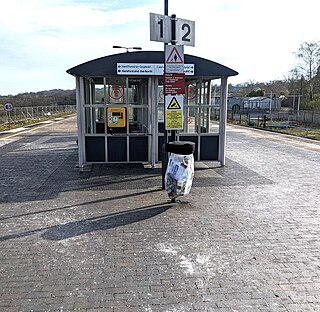
Hengoed railway station serves the village of Hengoed in the county borough of Caerphilly, South Wales. It is a stop on the Rhymney Line of the Valley Lines network.
Pontypool and New Inn railway station is situated to the south east of Pontypool town centre between the town and the suburb of New Inn, Wales. The station was formerly called Pontypool Road until renamed just Pontypool in 1972 and then to the present name in 1994.

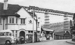
The Crumlin railway stations historically served the town of Crumlin, South Wales. Both stations are now closed and no longer exist.
Maesycwmmer is a village and community in the centre of Caerphilly County Borough in Wales, within the historic boundaries of Monmouthshire.
The Vale of Neath Railway (VoNR) was a broad gauge railway company, that built a line from Merthyr Tydfil and Aberdare to Neath, in Wales, mostly to transport the products of the Merthyr iron industries to ports on Swansea Bay.
The Pontypool, Caerleon and Newport Railway was promoted independently to relieve congestion on the heavily worked Eastern Valley Line of the Monmouthshire Railway and Canal Company. The Great Western Railway put up half the capital, making it in effect a GWR subsidiary. It opened in 1874, and most long-distance passenger and goods traffic, especially the heavy mineral traffic, transferred to it. It amalgamated with the GWR in 1876.
The Pontypridd, Caerphilly and Newport Railway was built to bring the coal output of the Aberdare and Rhondda valleys directly to Alexandra Docks at Newport.
The Merthyr, Tredegar and Abergavenny Railway, also known as the Heads of the Valleys line, was a railway line which operated between 1860 and 1958 between the Monmouthshire town of Abergavenny and the Glamorgan town of Merthyr Tydfil in South East Wales.
The Newport, Abergavenny and Hereford Railway was a railway company formed to connect the places in its name. When it sought parliamentary authorisation, it was denied the southern section, and obliged to use the Monmouthshire Railway between Pontypool and Newport.
The Monmouthshire Railway and Canal Company was a canal and railway company that operated a canal and a network of railways in the Western Valley and Eastern Valley of Newport, Monmouthshire. It started as the Monmouthshire Canal Navigation and opened canals from Newport to Pontypool and to Crumlin from 1796. Numerous tramroads connected nearby pits and ironworks with the canal.

Hafodyrynys is a village on the A472 road between Pontypool and Crumlin in Caerphilly county borough, south-east Wales. It lies within the historic boundaries of Monmouthshire.
The Llancaiach Branch railway line was a mineral branch line in Glamorganshire, South Wales. It was authorised in 1836 as part of the Taff Vale Railway, and its purpose was to connect collieries at Llancaiach and bring their output to Cardiff for onward shipment. It was designed by Isambard Kingdom Brunel and built on the standard gauge. It opened in 1841 from a junction with the Merthyr line immediately south of Abercynon. It was intended to be horse worked, and included a self-acting rope-worked inclined plane near the junction. The collieries were slow to use the line, preferring their customary use of a tramroad and the Glamorganshire Canal, and the value of the line was diminished when the Taff Vale Extension line, an east-west connecting line belonging to the Newport, Abergavenny and Hereford Railway, intersected it and cut off the colliery connections, and the line became dormant.

The Coleford, Monmouth, Usk & Pontypool Railway (CMU&PR) was a standard gauge railway of 16 miles (26 km) which ran from Monmouth to Little Mill, near Pontypool in Monmouthshire, Wales. It was intended to convey the mineral products of the Forest of Dean to the ironworks of South Wales, by connecting to the Newport, Abergavenny and Hereford Railway at Little Mill Junction. The NAHR made the onward connection over its Taff Vale Extension line. The CMU&PR intended to acquire the Monmouth Railway, actually a horse-operated plateway, and convert it to locomotive operation.
The Sirhowy Tramroad was a plateway built to convey the products of ironworks at Tredegar to Newport, South Wales. It opened in 1805 between Tredegar and Nine Mile Point, a location west of Risca, from where the Monmouthshire Canal Company operated a tramroad to Newport. The Sirhowy Tramroad was operated at first by horse traction, but early locomotives were used, and a passenger service was operated.
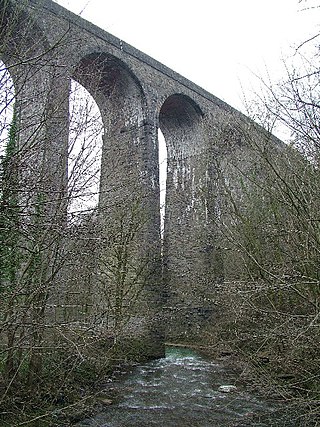
Hengoed Viaduct is a disused railway viaduct located above the village of Maesycwmmer, in Caerphilly county borough, South Wales. Grade II* listed, it was originally built to carry the Taff Vale Extension of the Newport, Abergavenny and Hereford Railway (NA&HR) across the Rhymney River, and is now part of National Cycle Route 47.

Walnut Tree Viaduct was a railway viaduct located above the southern edge of the village of Taffs Well, South Wales. Originally built to carry the Barry Railway across a narrow gorge through which the River Taff, Taff Vale Railway and Cardiff Railway passed, it was deconstructed in 1969, leaving only two of the support columns visible from the A470 road.
Pontypool Clarence Street railway station was a station on the former Taff Vale Extension (TVE) of the Newport, Abergavenny and Hereford Railway. The station opened 20 August 1855 to link up with the Taff Vale Railway (TVR) at Quakers Yard which connected onto Merthyr Tydfil. A major achievement of this railway was the building of the Crumlin Viaduct over the Ebbw River. The TVE linked directly with the Vale of Neath Railway at Merthyr and further linked Pontypool to Swansea and Neath. The main purpose of this line was the transport of coal across the country.

 Crumlin viaduct on the Newport, Abergavenny & Hereford railway extension to Taff vale ca 1865 by Newman and Co. (London, England)
 Crumlin Viaduct, on the Taff Vale Extension of the West Midland Railway ca 1855 by H J Cooke, fl ca 1855 and Maclure, Macdonald and Macgregor (lithographers), Engraver
 Crumlin viaduct. On the Newport, Abergavenny & Hereford railway extension to Taff vale ca 1865