Crustal recycling

Last updated
Understanding predictions of mantle dynamics helps geoscientists predict where subducted crust will end up. Models of mantle dynamics.jpg
Understanding predictions of mantle dynamics helps geoscientists predict where subducted crust will end up.

Crustal recycling is a tectonic process by which surface material from the lithosphere is recycled into the mantle by subduction erosion or delamination. The subducting slabs carry volatile compounds and water into the mantle, as well as crustal material with an isotopic signature different from that of primitive mantle. Identification of this crustal signature in mantle-derived rocks (such as mid-ocean ridge basalts or kimberlites) is proof of crustal recycling.

Contents

Historical and theoretical context

Between 1906 and 1936 seismological data were used by R.D. Oldham, A. Mohorovičić, B. Gutenberg and I. Lehmann to show that the earth consisted of a solid crust and mantle, a fluid outer core and a solid innermost core. [1] The development of seismology as a modern tool for imaging the Earth's deep interior occurred during the 1980s, [2] and with it developed two camps of geologists: whole-mantle convection proponents [3] [4] and layered-mantle convection proponents. [5] [6]

Layered-mantle convection proponents hold that the mantle's convective activity is layered, separated by densest-packing phase transitions of minerals like olivine, garnet and pyroxene to more dense crystal structures (spinel and then silicate perovskite and post-perovskite). Slabs that are subducted may be negatively buoyant as a result of being cold from their time on the surface and inundation with water, but this negative buoyancy is not enough to move through the 660-km phase transition.

Whole-mantle (simple) convection proponents hold that the mantle’s observed density differences (which are inferred to be products of mineral phase transitions) do not restrict convective motion, which moves through the upper and lower mantle as a single convective cell. Subducting slabs are able to move through the 660-km phase transition and collect near the bottom of the mantle in a 'slab graveyard', and may be the driving force for convection in the mantle locally [7] and on a crustal scale. [2]

The fate of subducted material

The ultimate fate of crustal material is key to understanding geochemical cycling, as well as persistent heterogeneities in the mantle, upwelling and myriad effects on magma composition, melting, plate tectonics, mantle dynamics and heat flow. [8] If slabs are stalled out at the 660-km boundary, as the layered-mantle hypothesis suggests, they cannot be incorporated into hot spot plumes, thought to originate at the core-mantle boundary. If slabs end up in a "slab graveyard" at the core-mantle boundary, they cannot be involved in flat slab subduction geometry. Mantle dynamics is likely a mix of the two end-member hypotheses, resulting in a partially layered mantle convection system.

The current understanding of the structure of the deep Earth is informed mostly by inference from direct and indirect measurements of mantle properties using seismology, petrology, isotope geochemistry and seismic tomography techniques. Seismology in particular is heavily relied upon for information about the deep mantle near the core-mantle boundary.

Evidence

Seismic tomography

Although seismic tomography was producing low-quality images [2] of the Earth's mantle in the 1980s, images published in a 1997 editorial article in the journal Science clearly showed a cool slab near the core-mantle boundary, [9] as did work completed in 2005 by Hutko et al., showing a seismic tomography image that may be cold, folded slab material at the core-mantle boundary. [10] However, the phase transitions may still play a role in the behavior of slabs at depth. Schellart et al. showed that the 660-km phase transition may serve to deflect downgoing slabs. [11] The shape of the subduction zone was also key in whether the geometry of the slab could overcome the phase transition boundary. [12]

Mineralogy may also play a role, as locally metastable olivine will form areas of positive buoyancy, even in a cold downgoing slab, and this could cause slabs to 'stall out' at the increased density of the 660-km phase transition. [13] Slab mineralogy and its evolution at depth [14] were not initially computed with information about the heating rate of a slab, which could prove essential to helping maintain negative buoyancy long enough to pierce the 660 km phase change. Additional work completed by Spasojevic et al. [15] showed that local minima in the geoid could be accounted for by the processes that occur in and around slab graveyards, as indicated in their models.

Stable isotopes

Understanding that the differences between Earth's layers are not just rheological, but chemical, is essential to understanding how we can track the movement of crustal material even after it has been subducted. After a rock has moved to the surface of the Earth from beneath the crust, that rock can be sampled for its stable isotopic composition. It can then be compared to known crustal and mantle isotopic compositions, as well as that of chondrites, which are understood to represent original material from the formation of the Solar System in a largely unaltered state.

One group of researchers was able to estimate that between 5 and 10% of the upper mantle is composed of recycled crustal material. [16] Kokfelt et al. completed an isotopic examination of the mantle plume under Iceland [17] and found that erupted mantle lavas incorporated lower crustal components, confirming crustal recycling at the local level.

Some carbonatite units, which are associated with immiscible volatile-rich magmas [18] and the mantle indicator mineral diamond, have shown isotopic signals for organic carbon, which could only have been introduced by subducted organic material. [19] [20] The work done on carbonatites by Walter et al. [18] and others [4] further develops the magmas at depth as being derived from dewatering slab material.

The δ34S isotopic signatures of magmas have also been used to measure the degree of crustal recycling over geologic time. [21]

Related Research Articles

<span class="mw-page-title-main">Lithosphere</span> Outermost shell of a terrestrial-type planet or natural satellite

A lithosphere is the rigid, outermost rocky shell of a terrestrial planet or natural satellite. On Earth, it is composed of the crust and the lithospheric mantle, the topmost portion of the upper mantle that behaves elastically on time scales of up to thousands of years or more. The crust and upper mantle are distinguished on the basis of chemistry and mineralogy.

<span class="mw-page-title-main">Subduction</span> A geological process at convergent tectonic plate boundaries where one plate moves under the other

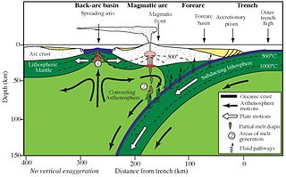
Subduction is a geological process in which the oceanic lithosphere and some continental lithosphere is recycled into the Earth's mantle at convergent boundaries. Where the oceanic lithosphere of a tectonic plate converges with the less dense lithosphere of a second plate, the heavier plate dives beneath the second plate and sinks into the mantle. A region where this process occurs is known as a subduction zone, and its surface expression is known as an arc-trench complex. The process of subduction has created most of the Earth's continental crust. Rates of subduction are typically measured in centimeters per year, with rates of convergence as high as 11 cm/year.

<span class="mw-page-title-main">Convergent boundary</span> Region of active deformation between colliding tectonic plates

A convergent boundary is an area on Earth where two or more lithospheric plates collide. One plate eventually slides beneath the other, a process known as subduction. The subduction zone can be defined by a plane where many earthquakes occur, called the Wadati–Benioff zone. These collisions happen on scales of millions to tens of millions of years and can lead to volcanism, earthquakes, orogenesis, destruction of lithosphere, and deformation. Convergent boundaries occur between oceanic-oceanic lithosphere, oceanic-continental lithosphere, and continental-continental lithosphere. The geologic features related to convergent boundaries vary depending on crust types.

<span class="mw-page-title-main">Mantle plume</span> Upwelling of abnormally hot rock within Earths mantle

A mantle plume is a proposed mechanism of convection within the Earth's mantle, hypothesized to explain anomalous volcanism. Because the plume head partially melts on reaching shallow depths, a plume is often invoked as the cause of volcanic hotspots, such as Hawaii or Iceland, and large igneous provinces such as the Deccan and Siberian Traps. Some such volcanic regions lie far from tectonic plate boundaries, while others represent unusually large-volume volcanism near plate boundaries.

<span class="mw-page-title-main">Island arc</span> Arc-shaped archipelago formed by intense seismic activity of long chains of active volcanoes

Island arcs are long chains of active volcanoes with intense seismic activity found along convergent tectonic plate boundaries. Most island arcs originate on oceanic crust and have resulted from the descent of the lithosphere into the mantle along the subduction zone. They are the principal way by which continental growth is achieved.

<span class="mw-page-title-main">Continental crust</span> Layer of rock that forms the continents and continental shelves

Continental crust is the layer of igneous, metamorphic, and sedimentary rocks that forms the geological continents and the areas of shallow seabed close to their shores, known as continental shelves. This layer is sometimes called sial because its bulk composition is richer in aluminium silicates (Al-Si) and has a lower density compared to the oceanic crust, called sima which is richer in magnesium silicate (Mg-Si) minerals. Changes in seismic wave velocities have shown that at a certain depth, there is a reasonably sharp contrast between the more felsic upper continental crust and the lower continental crust, which is more mafic in character.

<span class="mw-page-title-main">Earth's mantle</span> A layer of silicate rock between Earths crust and its outer core

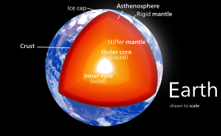
Earth's mantle is a layer of silicate rock between the crust and the outer core. It has a mass of 4.01×1024 kg (8.84×1024 lb) and thus makes up 67% of the mass of Earth. It has a thickness of 2,900 kilometers (1,800 mi) making up about 46% of Earth's radius and 84% of Earth's volume. It is predominantly solid but, on geologic time scales, it behaves as a viscous fluid, sometimes described as having the consistency of caramel. Partial melting of the mantle at mid-ocean ridges produces oceanic crust, and partial melting of the mantle at subduction zones produces continental crust.

<span class="mw-page-title-main">Back-arc basin</span> Submarine features associated with island arcs and subduction zones

A back-arc basin is a type of geologic basin, found at some convergent plate boundaries. Presently all back-arc basins are submarine features associated with island arcs and subduction zones, with many found in the western Pacific Ocean. Most of them result from tensional forces, caused by a process known as oceanic trench rollback, where a subduction zone moves towards the subducting plate. Back-arc basins were initially an unexpected phenomenon in plate tectonics, as convergent boundaries were expected to universally be zones of compression. However, in 1970, Dan Karig published a model of back-arc basins consistent with plate tectonics.

<span class="mw-page-title-main">Mantle convection</span> Gradual movement of the planets mantle

Mantle convection is the very slow creeping motion of Earth's solid silicate mantle as convection currents carry heat from the interior to the planet's surface.

<span class="mw-page-title-main">Adakite</span> Volcanic rock type

Adakites are volcanic rocks of intermediate to felsic composition that have geochemical characteristics of magma originally thought to have formed by partial melting of altered basalt that is subducted below volcanic arcs. Most magmas derived in subduction zones come from the mantle above the subducting plate when hydrous fluids are released from minerals that break down in the metamorphosed basalt, rise into the mantle, and initiate partial melting. However, Defant and Drummond recognized that when young oceanic crust is subducted, adakites are typically produced in the arc. They postulated that when young oceanic crust is subducted it is "warmer" than crust that is typically subducted. The warmer crust enables melting of the metamorphosed subducted basalt rather than the mantle above. Experimental work by several researchers has verified the geochemical characteristics of "slab melts" and the contention that melts can form from young and therefore warmer crust in subduction zones.

Slab pull is a geophysical mechanism whereby the cooling and subsequent densifying of a subducting tectonic plate produces a downward force along the rest of the plate. In 1975 Forsyth and Uyeda used the inverse theory method to show that, of the many forces likely to be driving plate motion, slab pull was the strongest. Plate motion is partly driven by the weight of cold, dense plates sinking into the mantle at oceanic trenches. This force and slab suction account for almost all of the force driving plate tectonics. The ridge push at rifts contributes only 5 to 10%.

<span class="mw-page-title-main">Ocean island basalt</span> Volcanic rock

Ocean island basalt (OIB) is a volcanic rock, usually basaltic in composition, erupted in oceans away from tectonic plate boundaries. Although ocean island basaltic magma is mainly erupted as basalt lava, the basaltic magma is sometimes modified by igneous differentiation to produce a range of other volcanic rock types, for example, rhyolite in Iceland, and phonolite and trachyte at the intraplate volcano Fernando de Noronha. Unlike mid-ocean ridge basalts (MORBs), which erupt at spreading centers (divergent plate boundaries), and volcanic arc lavas, which erupt at subduction zones (convergent plate boundaries), ocean island basalts are the result of intraplate volcanism. However, some ocean island basalt locations coincide with plate boundaries like Iceland, which sits on top of a mid-ocean ridge, and Samoa, which is located near a subduction zone.

<span class="mw-page-title-main">Slab (geology)</span> The portion of a tectonic plate that is being subducted

In geology, the slab is a significant constituent of subduction zones.

<span class="mw-page-title-main">Large low-shear-velocity provinces</span> Structures of the Earths mantle

Large low-shear-velocity provinces, LLSVPs, also called LLVPs or superplumes, are characteristic structures of parts of the lowermost mantle of Earth. These provinces are characterized by slow shear wave velocities and were discovered by seismic tomography of deep Earth. There are two main provinces: the African LLSVP and the Pacific LLSVP. Both extend laterally for thousands of kilometers and possibly up to 1,000 kilometres vertically from the core–mantle boundary. The Pacific LLSVP is 3,000 kilometers across, and underlies four hotspots that suggest multiple mantle plumes underneath. These zones represent around 8% of the volume of the mantle. Other names for LLSVPs include "superswells", "thermo-chemical piles", or "hidden reservoirs". Most of these names, however, are more interpretive of their proposed geodynamical or geochemical effects. For example, the name "thermo-chemical pile" interprets LLSVPs as lower-mantle piles of thermally hot and/or chemically distinct material. LLSVPs are still relatively mysterious, and many questions remain about their nature, origin, and geodynamic effects.

<span class="mw-page-title-main">Subduction zone metamorphism</span> Changes of rock due to pressure and heat near a subduction zone

A subduction zone is a region of the Earth's crust where one tectonic plate moves under another tectonic plate; oceanic crust gets recycled back into the mantle and continental crust gets created by the formation of arc magmas. Arc magmas account for more than 20% of terrestrially produced magmas and are produced by the dehydration of minerals within the subducting slab as it descends into the mantle and are accreted onto the base of the overriding continental plate. Subduction zones host a unique variety of rock types created by the high-pressure, low-temperature conditions a subducting slab encounters during its descent. The metamorphic conditions the slab passes through in this process creates and destroys water bearing (hydrous) mineral phases, releasing water into the mantle. This water lowers the melting point of mantle rock, initiating melting. Understanding the timing and conditions in which these dehydration reactions occur, is key to interpreting mantle melting, volcanic arc magmatism, and the formation of continental crust.

A continental arc is a type of volcanic arc occurring as an "arc-shape" topographic high region along a continental margin. The continental arc is formed at an active continental margin where two tectonic plates meet, and where one plate has continental crust and the other oceanic crust along the line of plate convergence, and a subduction zone develops. The magmatism and petrogenesis of continental crust are complicated: in essence, continental arcs reflect a mixture of oceanic crust materials, mantle wedge and continental crust materials.

<span class="mw-page-title-main">Deep water cycle</span> Movement of water in the deep Earth

The deep water cycle, or geologic water cycle, involves exchange of water with the mantle, with water carried down by subducting oceanic plates and returning through volcanic activity, distinct from the water cycle process that occurs above and on the surface of Earth. Some of the water makes it all the way to the lower mantle and may even reach the outer core. Mineral physics experiments show that hydrous minerals can carry water deep into the mantle in colder slabs and even "nominally anhydrous minerals" can store several oceans' worth of water.

The upper mantle of Earth is a very thick layer of rock inside the planet, which begins just beneath the crust and ends at the top of the lower mantle at 670 km (420 mi). Temperatures range from approximately 500 K at the upper boundary with the crust to approximately 1,200 K at the boundary with the lower mantle. Upper mantle material that has come up onto the surface comprises about 55% olivine, 35% pyroxene, and 5 to 10% of calcium oxide and aluminum oxide minerals such as plagioclase, spinel, or garnet, depending upon depth.

Ridge push is a proposed driving force for plate motion in plate tectonics that occurs at mid-ocean ridges as the result of the rigid lithosphere sliding down the hot, raised asthenosphere below mid-ocean ridges. Although it is called ridge push, the term is somewhat misleading; it is actually a body force that acts throughout an ocean plate, not just at the ridge, as a result of gravitational pull. The name comes from earlier models of plate tectonics in which ridge push was primarily ascribed to upwelling magma at mid-ocean ridges pushing or wedging the plates apart.

Intraplate volcanism is volcanism that takes place away from the margins of tectonic plates. Most volcanic activity takes place on plate margins, and there is broad consensus among geologists that this activity is explained well by the theory of plate tectonics. However, the origins of volcanic activity within plates remains controversial.

References

  1. Lowrie, W. (2007). Fundamentals of geophysics (2 ed.). Cambridge University Press. p. 121. ISBN   978-0-521-67596-3 . Retrieved 24 November 2011.
  2. 1 2 3 Kerr, R. A. (1997). "Geophysics: Deep-Sinking Slabs Stir the Mantle". Science. 275 (5300): 613–615. doi:10.1126/science.275.5300.613. S2CID   129593362.
  3. Gurnis, M. (1988). "Large-scale mantle convection and the aggregation and dispersal of supercontinents". Nature. 332 (6166): 695–699. Bibcode:1988Natur.332..695G. doi:10.1038/332695a0. S2CID   4233351.
  4. 1 2 Bercovici, D.; Karato, S. I. (2003). "Whole-mantle convection and the transition-zone water filter". Nature . 425 (6953): 39–44. Bibcode:2003Natur.425...39B. doi:10.1038/nature01918. PMID   12955133. S2CID   4428456.
  5. Albarede, F.; Van Der Hilst, R. D. (2002). "Zoned mantle convection". Philosophical Transactions of the Royal Society A: Mathematical, Physical and Engineering Sciences . 360 (1800): 2569–92. Bibcode:2002RSPTA.360.2569A. doi:10.1098/rsta.2002.1081. PMID   12460481. S2CID   1404118.
  6. Ogawa, M. (2003). "Chemical stratification in a two-dimensional convecting mantle with magmatism and moving plates". Journal of Geophysical Research . 108 (B12): 2561. Bibcode:2003JGRB..108.2561O. doi: 10.1029/2002JB002205 .
  7. Forte, A. M.; Mitrovica, J. X.; Moucha, R.; Simmons, N. A.; Grand, S. P. (2007). "Descent of the ancient Farallon slab drives localized mantle flow below the New Madrid seismic zone". Geophysical Research Letters. 34 (4): L04308. Bibcode:2007GeoRL..34.4308F. doi: 10.1029/2006GL027895 . S2CID   10662775.
  8. Lay, T. (1994). "The Fate of Descending Slabs". Annual Review of Earth and Planetary Sciences . 22: 33–61. Bibcode:1994AREPS..22...33L. doi:10.1146/annurev.ea.22.050194.000341. S2CID   53414293.
  9. Kerr, Richard A. (January 31, 1997). "Deep-Sinking Slabs Stir the Mantle". Science. 275 (5300): 613–615. doi:10.1126/science.275.5300.613. S2CID   129593362.
  10. Hutko, A. R.; Lay, T.; Garnero, E. J.; Revenaugh, J. (2006). "Seismic detection of folded, subducted lithosphere at the core–mantle boundary". Nature . 441 (7091): 333–336. Bibcode:2006Natur.441..333H. doi:10.1038/nature04757. PMID   16710418. S2CID   4408681.
  11. Schellart, W. P. (2004). "Kinematics of subduction and subduction-induced flow in the upper mantle". Journal of Geophysical Research . 109 (B7): B07401. Bibcode:2004JGRB..109.7401S. doi: 10.1029/2004JB002970 .
  12. Bercovici, D.; Schubert, G.; Tackley, P. J. (1993). "On the penetration of the 660 km phase change by mantle downflows". Geophysical Research Letters. 20 (23): 2599. Bibcode:1993GeoRL..20.2599B. doi:10.1029/93GL02691.
  13. Marton, F. C.; Bina, C. R.; Stein, S.; Rubie, D. C. (1999). "Effects of slab mineralogy on subduction rates" (PDF). Geophysical Research Letters . 26 (1): 119–122. Bibcode:1999GeoRL..26..119M. doi: 10.1029/1998GL900230 .
  14. Ganguly, J.; Freed, A.; Saxena, S. (2009). "Density profiles of oceanic slabs and surrounding mantle: Integrated thermodynamic and thermal modeling, and implications for the fate of slabs at the 660km discontinuity". Physics of the Earth and Planetary Interiors . 172 (3–4): 257. Bibcode:2009PEPI..172..257G. doi:10.1016/j.pepi.2008.10.005.
  15. Spasojevic, S.; Gurnis, M.; Sutherland, R. (2010). "Mantle upwellings above slab graveyards linked to the global geoid lows". Nature Geoscience . 3 (6): 435. Bibcode:2010NatGe...3..435S. doi:10.1038/NGEO855. S2CID   56369721.
  16. Cooper, K. M.; Eiler, J. M.; Sims, K. W. W.; Langmuir, C. H. (2009). "Distribution of recycled crust within the upper mantle: Insights from the oxygen isotope composition of MORB from the Australian-Antarctic Discordance". Geochemistry, Geophysics, Geosystems . 10 (12): n/a. Bibcode:2009GGG....1012004C. doi:10.1029/2009GC002728. hdl: 1912/3565 . S2CID   34164402.
  17. Kokfelt, T. F.; Hoernle, K. A. J.; Hauff, F.; Fiebig, J.; Werner, R.; Garbe-Schönberg, D. (2006). "Combined Trace Element and Pb-Nd-Sr-O Isotope Evidence for Recycled Oceanic Crust (Upper and Lower) in the Iceland Mantle Plume". Journal of Petrology . 47 (9): 1705. Bibcode:2006JPet...47.1705K. doi: 10.1093/petrology/egl025 .
  18. 1 2 Walter, M. J.; Bulanova, G. P.; Armstrong, L. S.; Keshav, S.; Blundy, J. D.; Gudfinnsson, G.; Lord, O. T.; Lennie, A. R.; Clark, S. M.; Smith, C. B.; Gobbo, L. (2008). "Primary carbonatite melt from deeply subducted oceanic crust". Nature . 454 (7204): 622–625. Bibcode:2008Natur.454..622W. doi:10.1038/nature07132. PMID   18668105. S2CID   4429507.
  19. Riches, A. J. V.; Liu, Y.; Day, J. M. D.; Spetsius, Z. V. [in Russian]; Taylor, L. A. (2010). "Subducted oceanic crust as diamond hosts revealed by garnets of mantle xenoliths from Nyurbinskaya, Siberia". Lithos. 120 (3–4): 368. Bibcode:2010Litho.120..368R. doi:10.1016/j.lithos.2010.09.006.
  20. Shcheka, S. S.; Wiedenbeck, M.; Frost, D. J.; Keppler, H. (2006). "Carbon solubility in mantle minerals". Earth and Planetary Science Letters . 245 (3–4): 730. Bibcode:2006E&PSL.245..730S. doi: 10.1016/j.epsl.2006.03.036 .
  21. Hutchison, William; Babiel, Rainer J.; Finch, Adrian A.; Marks, Michael A. W.; Markl, Gregor; Boyce, Adrian J.; Stüeken, Eva E.; Friis, Henrik; Borst, Anouk M.; Horsburgh, Nicola J. (16 September 2019). "Sulphur isotopes of alkaline magmas unlock long-term records of crustal recycling on Earth". Nature Communications . 10 (1): 4208. doi: 10.1038/s41467-019-12218-1 . ISSN   2041-1723. PMC   6746797 . Retrieved 30 September 2023.