
Glen Canyon Dam is a concrete arch-gravity dam in the southwestern United States, located on the Colorado River in northern Arizona, near the town of Page. The 710-foot-high (220 m) dam was built by the Bureau of Reclamation (USBR) from 1956 to 1966 and forms Lake Powell, one of the largest man-made reservoirs in the U.S. with a capacity of more than 25 million acre-feet (31 km3). The dam is named for Glen Canyon, a series of deep sandstone gorges now flooded by the reservoir; Lake Powell is named for John Wesley Powell, who in 1869 led the first expedition to traverse the Colorado River's Grand Canyon by boat.

The Gunnison River is located in western Colorado, United States and is one of the largest tributaries of the Colorado River.

Curecanti National Recreation Area is a National Park Service unit located on the Gunnison River in western Colorado. Established in 1965, Curecanti National Recreation Area is responsible for developing and managing recreational facilities on three reservoirs, Blue Mesa Reservoir, Morrow Point Reservoir and Crystal Reservoir, constructed on the upper Gunnison River in the 1960s by the U.S. Bureau of Reclamation to better utilize the vital waters of the Colorado River and its major tributaries. A popular destination for boating and fishing, Curecanti offers visitors two marinas, traditional and group campgrounds, hiking trails, boat launches, and boat-in campsites. The state's premiere lake trout and Kokanee salmon fisheries, Curecanti is a popular destination for boating and fishing, and is also a popular area for ice-fishing in the winter months.

Pathfinder Dam is a masonry dam, located on the North Platte River, approximately 47 miles (76 km) southwest of Casper, Wyoming. It was originally constructed from 1905 to 1909 as part of the North Platte Project and has been modified several times since then. It is included on the National Register of Historic Places. Construction of the dam created Pathfinder Reservoir which provides water storage for 226,000 acres (910 km2) of irrigation in Wyoming and Nebraska. The dam is named for General John Charles Fremont, who had explored the area in 1842 and was nicknamed the "Pathfinder of the West."

Flaming Gorge Dam is a concrete thin-arch dam on the Green River, a major tributary of the Colorado River, in northern Utah in the United States. Flaming Gorge Dam forms the Flaming Gorge Reservoir, which extends 91 miles (146 km) into southern Wyoming, submerging four distinct gorges of the Green River. The dam is a major component of the Colorado River Storage Project, which stores and distributes upper Colorado River Basin water.

Blue Mesa Reservoir is an artificial reservoir located on the upper reaches of the Gunnison River in Gunnison County, Colorado. The largest lake located entirely within the state, Blue Mesa Reservoir was created by the construction of Blue Mesa Dam, a 390 feet (120 m) tall earthen fill dam constructed on the Gunnison by the U.S. Bureau of Reclamation in 1966 for the generation of hydroelectric power. Managed as part of the Curecanti National Recreation Area, a unit of the National Park Service, Blue Mesa Reservoir is the largest lake trout and Kokanee salmon fishery in Colorado.

Blue Mesa Dam is a 390-foot-tall (120 m) zoned earthfill dam on the Gunnison River in Colorado. It creates Blue Mesa Reservoir, and is within Curecanti National Recreation Area just before the river enters the Black Canyon of the Gunnison. The dam is upstream of the Morrow Point Dam. Blue Mesa Dam and reservoir are part of the Bureau of Reclamation's Wayne N. Aspinall Unit of the Colorado River Storage Project, which retains the waters of the Colorado River and its tributaries for agricultural and municipal use in the American Southwest. Although the dam does produce hydroelectric power, its primary purpose is water storage. State Highway 92 passes over the top of the dam. Blue Mesa Dam houses two turbine generators and produces an average of 264,329,000 kilowatt-hours each year.
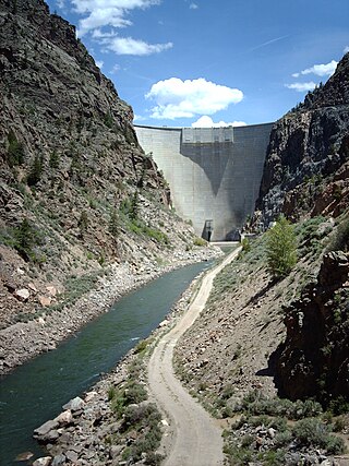
Morrow Point Dam is a 468-foot-tall (143 m) concrete double-arch dam on the Gunnison River located in Colorado, the first dam of its type built by the U.S. Bureau of Reclamation. Located in the upper Black Canyon of the Gunnison, it creates Morrow Point Reservoir, and is within the National Park Service-operated Curecanti National Recreation Area. The dam is between the Blue Mesa Dam (upstream) and the Crystal Dam (downstream). Morrow Point Dam and reservoir are part of the Bureau of Reclamation's Wayne N. Aspinall Unit of the Colorado River Storage Project, which retains the waters of the Colorado River and its tributaries for agricultural and municipal use in the American Southwest. The dam's primary purpose is hydroelectric power generation.

Navajo Dam is a dam on the San Juan River, a tributary of the Colorado River, in northwestern New Mexico in the United States. The 402-foot (123 m) high earthen dam is situated in the foothills of the San Juan Mountains about 44 miles (71 km) upstream and east of Farmington, New Mexico. It was built by the U.S. Bureau of Reclamation (Reclamation) in the 1960s to provide flood control, irrigation, domestic and industrial water supply, and storage for droughts. A small hydroelectric power plant was added in the 1980s.

Yellowtail Dam is a dam across the Bighorn River in south central Montana in the United States. The mid-1960s era concrete arch dam serves to regulate the flow of the Bighorn for irrigation purposes and to generate hydroelectric power. The dam and its reservoir, Bighorn Lake, are owned by the U.S. Bureau of Reclamation.

Auburn Dam was a proposed concrete arch dam on the North Fork of the American River east of the town of Auburn, California, in the United States, on the border of Placer and El Dorado Counties. Slated to be completed in the 1970s by the U.S. Bureau of Reclamation, it would have been the tallest concrete dam in California and one of the tallest in the United States, at a height of 680 feet (210 m) and storing 2,300,000 acre-feet (2.8 km3) of water. Straddling a gorge downstream of the confluence of the North and Middle Forks of the American River and upstream of Folsom Lake, it would have regulated water flow and provided flood control in the American River basin as part of Reclamation's immense Central Valley Project.

The Colorado River Storage Project is a United States Bureau of Reclamation project designed to oversee the development of the upper basin of the Colorado River. The project provides hydroelectric power, flood control and water storage for participating states along the upper portion of the Colorado River and its major tributaries.

The Curecanti Needle is a 700-ft granite spire located on the Gunnison River in western Colorado. A notable landmark to generations of natives and pioneers, the Needle is located on the southern bank of Morrow Point Reservoir, an impoundment of the Gunnison river between Gunnison and Montrose, Colorado. Used for many years as an advertising symbol for the Denver and Rio Grande Western Railroad, whose narrow-gauge railway famously ran along the northern bank of the river and passed near the Needle, the spire is today part of the Curecanti National Recreation Area, a National Park Service facility that encompasses three impoundments of the Gunnison river, including Morrow Point Reservoir.

Fontenelle Dam was built between 1961 and 1964 on the Green River in southwestern Wyoming. The 139-foot (42 m) high zoned earthfill dam impounds the 345,360-acre-foot (0.42600 km3) Fontenelle Reservoir. The dam and reservoir are the central features of the Seedskadee Project of the U.S. Bureau of Reclamation, which manages the Fontenelle impoundment primarily as a storage reservoir for the Colorado River Storage Project. The dam suffered a significant failure in 1965, when the dam's right abutment developed a leak. Emergency releases from the dam flooded downstream properties, but repairs to the dam were successful. However, in 1983 the dam was rated "poor" under Safety Evaluation of Existing Dams (SEED) criteria, due to continuing seepage, leading to an emergency drawdown. A concrete diaphragm wall was built through the core of the dam to stop leakage.

Seminoe Dam is a concrete thick-arch dam on the North Platte River in the U.S. state of Wyoming. The dam stores water for irrigation and hydroelectricity generation, and is owned and operated by the U.S. Bureau of Reclamation. It is the uppermost dam on the North Platte River and is located directly upstream from the Kortes Dam. It lies in a narrow, isolated canyon formed by the North Platte cutting through the Seminoe Mountains about 40 miles (64 km) northeast of Rawlins. The 295-foot (90 m) dam forms Seminoe Reservoir, which covers more than 20,000 acres (8,100 ha) when full. Seminoe State Park is adjacent to the reservoir. The small village of Seminoe Dam abuts the dam and reservoir, and provides residence for the dam attendants and park services personnel.

The Boysen Dam is a rockfill dam on the Wind River in the U.S. state of Wyoming. The dam lies at the head of Wind River Canyon through the Owl Creek Mountains in western Wyoming and creates Boysen Reservoir. It is owned by the U.S. Bureau of Reclamation and furnishes irrigation water supply to the Bighorn Basin as well as providing flood control and hydroelectric power.

Morrow Point Reservoir is an 817-acre (331 ha) artificial reservoir on the Gunnison River in western Colorado. Located in the upper Black Canyon of the Gunnison, the lake was created in 1968 by the U.S. Bureau of Reclamation as part of a larger plan to impound the upper section of the Gunnison and create opportunities for hydroelectric power generation, water conservation, and recreation. Morrow Point Reservoir is managed by the National Park Service as a unit within the Curecanti National Recreation Area, and is the location of the Curecanti Needle, a striking 700-foot (210 m) granite spire on the reservoir's southern bank whose unique shape was for decades a recognized symbol of the Denver and Rio Grande Western Railroad.
Crystal Reservoir is a 340-acre artificial reservoir on the Gunnison River in western Colorado. Located in the upper Black Canyon of the Gunnison, the lake was created in 1976 by the U.S. Bureau of Reclamation as part of a larger plan to impound the upper section of the Gunnison for the generation of hydroelectric power, water storage, and public recreation. Crystal Reservoir is managed by the National Park Service as an element of the Curecanti National Recreation Area. Located at the far western end of Curecanti, Crystal Reservoir is the smallest, least developed, and least accessible of the three reservoirs within the park.

Blue Creek is a tributary of the Gunnison River in Gunnison County, Colorado. It forms at the confluence of Little Blue Creek and Big Blue Creek adjacent to the intersection of U.S. Highway 50 and Alpine Plateau Road in Blue Creek Canyon.


