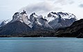
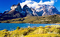
Cuernos del Paine are 2,600-meter-elevation (8,530-foot) peaks in the Cordillera Paine group of the Andes. The peaks are located 95kilometers (59miles) north-northwest of Puerto Natales and the peaks are within Torres del Paine National Park.[2] Precipitation runoff from the mountain's slopes drains into Nordenskjöld Lake which is part of the Paine River watershed. Topographic relief is significant as the summit rises 2,525meters (8,284feet) above the lake in 2.5kilometers (1.55miles). The mountain's toponym translates as "Horns of Paine" wherein "Paine" in the native Tehuelche language means "blue" which describes the color of the park's lakes. The nearest higher peak is Monte Almirante Nieto, 4.3kilometers (2.7miles) to the northeast.[2]
Climbing history
The first ascent of Cuerno Principal (Main Horn) was accomplished on January 31, 1968, via the southwest ridge by Raúl Aguilera, Eduardo García, Osvaldo Latorre, and Gaston Oyarzún, all four from the University of Santiago, Chile.[3]
The first ascent of Cuerno Norte (North Horn) was accomplished on December 30, 1971, by Paul Fatti, Richard Hoare, Michael Scott, Paul Andersen, Roger Fuggle, and Tony Dick.[4]
The first successful ascent of Cuerno Este (East Horn) was accomplished on January 19, 2022, by Pepo Jurado, Romano Marcotti, and Sebastian Pelletti via a class5.11- route they named Vacaciones Metamórficas.[5]
Climate
Based on the Köppen climate classification, Cuernos del Paine is located in a tundra climate zone with long, cold winters, and short, cool summers.[6] Weather systems are forced upward by the mountains (orographic lift), causing moisture to drop in the form of rain and snow. The months of December through February offer the most favorable weather for visiting or climbing in this area,[7] however the region is characterized by low temperatures and strong winds throughout the year.[8]
The range is made up of granite underlain by grey gabbro-diorite laccolith and the sedimentary rocks it intrudes, deeply eroded by glaciers. The hot granite that intruded parallel to the sedimentary rock converted the mudstone and sandstone into a dark metamorphic rock. The steep, light colored faces are eroded from the tougher, vertically jointed granitic rocks, while the foothills and dark cap rocks are the sedimentary country rock, in this case flysch deposited in the Cretaceous and later folded.[9]
The radiometric age for the quartz diorite is 12±2 million years by the rubidium-strontium method and 13±1 million years by the potassium-argon method.[10] More precise ages of 12.59±0.02 and 12.50±0.02 million years for the earliest and latest identified phases of the intrusion, respectively, were achieved using Uranium–lead dating methods on single zircon crystals.[11] Basal gabbro and diorite were dated by a similar technique to 12.472±0.009 to 12.431±0.006 million years.[12] Thus, magma was intruded and crystallized over 162±11 thousand years.
↑Martin Halpern "Regional Geochronology of Chile South of 50 degrees Latitude", Bulletin Geological Society of America, v. 84, p. 2410, 1973.
↑Juergen Michel, Lukas Baumgartner, Benita Putlitz, Urs Schaltegger and Maria Ovtcharova, Incremental growth of the Patagonian Torres del Paine Laccolith over 90 k.y., Geology, 36(6):459–462, 2008.
↑Leuthold, Julien; Müntener, Othmar; Baumgartner, Lukas; Putlitz, Benita; Ovtcharova, Maria; Schaltegger, Urs (2012). "Time resolved construction of a bimodal laccolith (Torres del Paine, Patagonia)". Earth and Planetary Science Letters. 325–326: 85–92. Bibcode:2012E&PSL.325...85L. doi:10.1016/j.epsl.2012.01.032.
This page is based on this Wikipedia article Text is available under the CC BY-SA 4.0 license; additional terms may apply. Images, videos and audio are available under their respective licenses.