
Mount Whitney is the highest mountain in the contiguous United States, with an elevation of 14,505 feet (4,421 m). It is in East–Central California, in the Sierra Nevada, on the boundary between California's Inyo and Tulare counties, and 84.6 miles (136.2 km) west-northwest of North America's lowest topographic point, Badwater Basin in Death Valley National Park, at 282 ft (86 m) below sea level. The mountain's west slope is in Sequoia National Park and the summit is the southern terminus of the John Muir Trail, which runs 211.9 mi (341.0 km) from Happy Isles in Yosemite Valley. The eastern slopes are in Inyo National Forest in Inyo County. Mount Whitney is ranked 18th by topographic isolation.

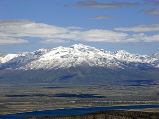
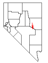
Wheeler Peak is the tallest mountain in the Snake Range and in White Pine County, in Nevada, United States. The summit elevation of 13,065 feet (3,982 m) makes it the second-highest peak in Nevada, just behind Boundary Peak. With a topographic prominence of 7,563 feet (2,305 m), Wheeler Peak is the most topographically prominent peak in White Pine County and the second-most prominent peak in Nevada, just behind Mount Charleston. The mountain is located in Great Basin National Park and was named for George Wheeler, leader of the Wheeler Survey of the late 19th century.

Boundary Peak is a mountain in Esmeralda County, Nevada, United States. With a peak elevation of 13,147 feet (4,007 m), it is the highest natural point in the state of Nevada.

White Mountain Peak, at 14,252 feet (4,344 m), is the highest peak in the White Mountains of California, the highest peak in Mono County, and the third highest peak in the state after Mount Whitney and Mount Williamson. In spite of its name, the summit block of the peak has large swaths of very dark and colorful orange scree and rock; it is composed of Mesozoic metavolcanic rock, which is igneous rock altered by rising granite.

Junipero Serra Peak is the highest mountain in the Santa Lucia range of central California with a height of 1,785 metres. It is also the highest peak in Monterey County, and is located within the boundaries of Los Padres National Forest. It is named after Saint Junípero Serra, the Spanish Franciscan priest who founded the California Missions in the 18th century. There is a fire lookout, with a tower and building, near the peak that was constructed around 1935. An unauthorized skiing operation on the summit was reported sometime before 1970. Good astronomical observing conditions were an early attraction to the peak. Astronomers scratched a trail to the summit in January 1880 to observe a total eclipse of the sun. Observations from the peak were also made on the transit of Venus in 1882.
Ruby Dome is the highest mountain in both the Ruby Mountains and Elko County, in Nevada, United States. It is the twenty-seventh-highest mountain in the state, and also ranks as the thirteenth-most topographically prominent peak in the state. The peak is located about 21 miles (34 km) southeast of the city of Elko within the Ruby Mountains Ranger District of the Humboldt-Toiyabe National Forest. The mountain rises from a base elevation of about 6,000 feet (1,800 m) to a height of 11,387 feet (3,471 m). It is the highest mountain for over 90 miles in all directions.

Telescope Peak is the highest point within Death Valley National Park, in the U.S. state of California. It is also the highest point of the Panamint Range, and lies in Inyo County. From atop this desert mountain one can see for over one hundred miles in many directions, including west to Mount Whitney, and east to Charleston Peak. The mountain was named for the great distance visible from the summit.

The Snake Range is a mountain range in White Pine County, Nevada, United States. The south-central portion of the range is included within Great Basin National Park, with most of the remainder included within the Humboldt-Toiyabe National Forest. The range reaches a maximum elevation of 13,065 feet (3,982 m) at the summit of Wheeler Peak, the tallest independent mountain within Nevada and the second highest point within the state. The range also contains four of the five highest mountain peaks in Nevada, including all peaks greater than 12,000 feet (3,658 m) except for Boundary Peak.
The White Pine Range is a group of mountains in southern White Pine County, in eastern Nevada. The range runs for approximately 51 miles (82 km) from Beck Pass in the north to Currant Pass in the south. To the west of the range are the Duckwater (Shoshone) tribal lands and the northern arm of large Railroad Valley. To the east are Jakes Valley and the northern part of the long White River Valley. To the south are the Horse and Grant Ranges.

Mount Moriah is a 12,072-foot (3,680 m) mountain in the northern Snake Range of eastern White Pine County, Nevada, United States. It is the fifth-highest mountain in the state, and ranks as the ninth-most topographically prominent peak in the state. It is located in the Mount Moriah Wilderness administered by the Humboldt-Toiyabe National Forest.

Arc Dome is the highest mountain of the Toiyabe Range in northwestern Nye County, Nevada, United States. It is the thirteenth-highest mountain in the state. Arc Dome also ranks as the second-most topographically prominent peak in Nye County and the eighth-most prominent peak in the state. The peak is located about 53 miles (85 km) north of the community of Tonopah, within the Arc Dome Wilderness of the Humboldt-Toiyabe National Forest.

Mount Jefferson is the highest mountain in both the Toquima Range and Nye County in Nevada, United States. It is the sixth highest mountain in the state. As the high point of a range which is well separated from other ranges by low basins, Mount Jefferson has a high topographic prominence of 5,861 feet (1,786 m). This makes it the most prominent peak in Nye County and the third most prominent peak in Nevada. For similar reasons, it is also the highest mountain for over 90 miles in all directions. It is located about 50 miles (80 km) northeast of the county seat of Tonopah within the Alta Toquima Wilderness of the Humboldt-Toiyabe National Forest, near the smaller towns of Carvers and Round Mountain. Three distinct summits are located on a broad area of subalpine tundra: North Summit rises to 11,820 feet (3,603 m), Middle Summit to 11,692 feet (3,564 m), and South Summit to 11,949 feet (3,642 m). During the Pleistocene, alpine glaciers eroded several cirques east of the summit plateau.

North Schell Peak is the highest mountain in the Schell Creek Range of White Pine County, Nevada, United States. It is the ninth-highest mountain in the state, and also ranks as the fifth-most topographically prominent peak in the state. The summit is 19 miles (31 km) northeast of the community of Ely within the High Schells Wilderness of the Humboldt-Toiyabe National Forest.

Troy Peak is the highest mountain in the Grant Range in northeastern Nye County, Nevada, United States. It is the thirty-sixth highest mountain in Nevada. Troy Peak also ranks as the third-most topographically prominent peak in Nye County and the fourteenth-most prominent peak in the state. The summit is located 72 miles (116 km) southwest of the city of Ely, within the Grant Range Wilderness of the Humboldt-Toiyabe National Forest.

Diamond Peak is both the highest and most topographically prominent mountain in both the Diamond Mountains and Eureka County, in Nevada, United States. It ranks thirty-ninth among the most topographically prominent peaks in the state. The peak is located on the border of Eureka County and White Pine County, about 12 miles northeast of the small town of Eureka, between the south end of Diamond Valley and the central portion of Newark Valley. It is on public land administered by the Bureau of Land Management and thus has no access restrictions.

Round Top is a 10,381-foot (3,164 m) mountain located on the Sierra crest in Alpine County, California, United States. Its summit is the highest point in Eldorado National Forest and the Mokelumne Wilderness. The mountain lies just south of Carson Pass. With 2,541 feet (774 m) of prominence, Round Top is the 16th most prominent mountain in the Sierra Nevada.


