Peat is an accumulation of partially decayed vegetation or organic matter. It is unique to natural areas called peatlands, bogs, mires, moors, or muskegs. Sphagnum moss, also called peat moss, is one of the most common components in peat, although many other plants can contribute. The biological features of sphagnum mosses act to create a habitat aiding peat formation, a phenomenon termed 'habitat manipulation'. Soils consisting primarily of peat are known as histosols. Peat forms in wetland conditions, where flooding or stagnant water obstructs the flow of oxygen from the atmosphere, slowing the rate of decomposition. Peat properties such as organic matter content and saturated hydraulic conductivity can exhibit high spatial heterogeneity.
The Global 200 is the list of ecoregions identified by the World Wide Fund for Nature (WWF), the global conservation organization, as priorities for conservation. According to WWF, an ecoregion is defined as a "relatively large unit of land or water containing a characteristic set of natural communities that share a large majority of their species dynamics, and environmental conditions". For example, based on their levels of endemism, Madagascar gets multiple listings, ancient Lake Baikal gets one, and the North American Great Lakes get none.

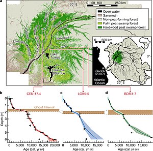
The Congo Basin is the sedimentary basin of the Congo River. The Congo Basin is located in Central Africa, in a region known as west equatorial Africa. The Congo Basin region is sometimes known simply as the Congo. It contains some of the largest tropical rainforests in the world and is an important source of water used in agriculture and energy generation.
Peat swamp forests are tropical moist forests where waterlogged soil prevents dead leaves and wood from fully decomposing. Over time, this creates a thick layer of acidic peat. Large areas of these forests are being logged at high rates.

The Congolian rainforests are a broad belt of lowland tropical moist broadleaf forests which extend across the basin of the Congo River and its tributaries in Central Africa.
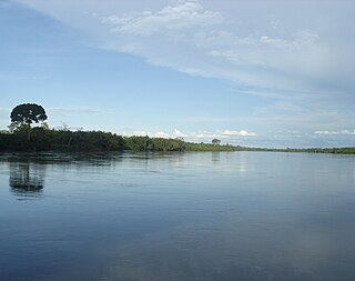
The Western Congolian swamp forests are an ecoregion of the Republic of the Congo, Democratic Republic of the Congo and adjoining Central African Republic. Together with the adjacent Eastern Congolian swamp forests, it forms one of the largest continuous areas of freshwater swamp forest in the world. It is a flooded forest with a high canopy, dense undergrowth and has a muddy floor. It has not been disturbed very much by outside influences and so remains largely pristine as getting through this forest is called "almost impossible".

Freshwater swamp forests, or flooded forests, are forests which are inundated with freshwater, either permanently or seasonally. They normally occur along the lower reaches of rivers and around freshwater lakes. Freshwater swamp forests are found in a range of climate zones, from boreal through temperate and subtropical to tropical.

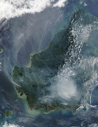
The Borneo peat swamp forests ecoregion, within the tropical and subtropical moist broadleaf forests biome, are on the island of Borneo, which is divided between Brunei, Indonesia and Malaysia.

Tropical peat is a type of histosol that is found in tropical latitudes, including South East Asia, Africa, and Central and South America. Tropical peat mostly consists of dead organic matter from trees instead of spaghnum which are commonly found in temperate peat. This soils usually contain high organic matter content, exceeding 75% with dry low bulk density around 0.2 mg/m3 (0.0 gr/cu ft).

In climate science, a tipping point is a critical threshold that, when crossed, leads to large, accelerating and often irreversible changes in the climate system. If tipping points are crossed, they are likely to have severe impacts on human society and may accelerate global warming. Tipping behavior is found across the climate system, for example in ice sheets, mountain glaciers, circulation patterns in the ocean, in ecosystems, and the atmosphere. Examples of tipping points include thawing permafrost, which will release methane, a powerful greenhouse gas, or melting ice sheets and glaciers reducing Earth's albedo, which would warm the planet faster. Thawing permafrost is a threat multiplier because it holds roughly twice as much carbon as the amount currently circulating in the atmosphere.

The Central Congolian lowland forests are an ecoregion within the Democratic Republic of the Congo. This is a remote, inaccessible area of low-lying dense wet forest, undergrowth and swamp in the Cuvette Centrale region of the Congo Basin south of the arc of the River Congo.
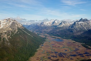
A peatland is a type of wetland whose soils consist of organic matter from decaying plants, forming layers of peat. Peatlands arise because of incomplete decomposition of organic matter, usually litter from vegetation, due to water-logging and subsequent anoxia. Peatlands are unusual landforms that derive mostly from biological rather than physical processes, and can take on characteristic shapes and surface patterning.

The Eastern Congolian swamp forests are a fairly intact but underresearched ecoregion of the tropical and subtropical moist broadleaf forests biome. It is located within the Democratic Republic of the Congo. This is the eastern half of one of the largest areas of swamps in the world.

The southern Congolian forest–savanna mosaic is an ecoregion that covers a large area of the southern Democratic Republic of the Congo and northeastern Angola. Its rich blend of habitats provides key insights into the biogeography of central Africa with the extensive climatic variation that it has been experiencing for the last 10 million years. The human population is not high.
Paludiculture is wet agriculture and forestry on peatlands. Paludiculture combines the reduction of greenhouse gas emissions from drained peatlands through rewetting with continued land use and biomass production under wet conditions. “Paludi” comes from the Latin “palus” meaning “swamp, morass” and "paludiculture" as a concept was developed at Greifswald University. Paludiculture is a sustainable alternative to drainage-based agriculture, intended to maintain carbon storage in peatlands. This differentiates paludiculture from agriculture like rice paddies, which involve draining, and therefore degrading wetlands.

The Northwestern Congolian lowland forests is a tropical moist broadleaf forest ecoregion that spans Cameroon, Gabon, the Republic of Congo, the Central African Republic and a minuscule part of the Democratic Republic of the Congo. It forms part of the larger Congolian rainforests region in Central Africa. The region is noteworthy for very high levels of species richness and endemism. It is home to a core population of the critically endangered Western lowland gorilla. There are also large populations of forest elephants.
The Global Peatlands Initiative is an effort made by leading experts and institutions formed in 2016 by 13 founding members at the UNFCCC COP in Marrakech, Morocco. The mission of the Initiative is to protect and conserve peatlands as the world's largest terrestrial organic carbon stock and to prevent it from being emitted into the atmosphere.
The Guineo-Congolian region is a biogeographical region in Africa straddling the Equator and stretching from the Atlantic Ocean through the Congo Basin to the Congo / Nile divide in Rwanda and Burundi. Formerly, this region was largely covered in rain forest, on both well-drained sites and in swamp forests, but little undisturbed primary forest now remains, having been replaced in many areas by savanna and secondary-growth forest.

Cuvette Centrale Province was a province of the Democratic Republic of the Congo that existed between 1963 and 1966 during the Congo Crisis.