The Victorian gold rush was a period in the history of Victoria, Australia approximately between 1851 and the late 1860s. It led to a period of extreme prosperity for the Australian colony, and an influx of population growth and financial capital for Melbourne, which was dubbed "Marvellous Melbourne" as a result of the procurement of wealth.

Panton Hill is a town in Victoria, Australia, 32 km north-east of Melbourne's Central Business District. Its local government area is the Shire of Nillumbik. At the 2016 census, Panton Hill had a population of 1,062.

St Andrews is a town in Victoria, Australia, 52 km north-east of Melbourne's Central Business District. Its local government area is the Shire of Nillumbik. At the 2016 census, St Andrews had a population of 1,226.

Harry Francis Anstey was a metallurgist and gold prospector who led the prospecting expedition that discovered gold in the Yilgarn, leading to the gold rush that established Western Australia's Eastern Goldfields.

Avoca is a town in the Central Highlands of Victoria, Australia, 71 kilometres (44 mi) north west of Ballarat. It is one of two main towns in the Pyrenees Shire, the other being Beaufort to the south.

Maryborough is a town in Victoria, Australia, on the Pyrenees Highway, 58 kilometres (36 mi) north of Ballarat and 168 kilometres (104 mi) northwest of Melbourne, in the Shire of Central Goldfields. At the 2016 census, it had a population of 7,921.

Moliagul is a small township in Victoria, Australia, 202 kilometres (126 mi) northwest of Melbourne and 60 kilometres (37 mi) west of Bendigo. The town's name is believed to be a derivation of the aboriginal word "moliagulk", meaning "wooded hill". The area is notable for the discovery of a number of gold nuggets. These finds include the world's largest, the Welcome Stranger, which was discovered in 1869 by John Deason and Richard Oates.
Matlock is a rural locality in the Shire of Mansfield in Victoria. The locality is named after the township that existed at two separate locations from the early 1860s to about the 1930s. Matlock rural locality is along the Walhalla Road, about 140 kilometres north-east of Melbourne, high in the Victorian alpine region on the Great Dividing Range. The location of Matlock township from the early 1860s to 1873 is on a barren hilltop known as the Matlock Hill Historical Area, marked by a snow shelter at the roadside picnic area and the remnants of a cemetery. At 1,213 metres above sea-level at its first location Matlock was the highest township in Victoria.

Dunolly is a town in Victoria, Australia, located on the Dunolly - Maryborough Road, in the Shire of Central Goldfields. At the 2016 census, Dunolly had a population of 893, down from 969 in 2006.

Amherst is a former municipality and gold rush town situated within the Shire of Central Goldfields in Victoria, Australia. Much of the original township has been destroyed by fire, and little remains other than Amherst Cemetery at 235 Avoca Road, Talbot.
Adelaide Lead is a district in Victoria, Australia, site of a former settlement, located on Old Avoca Road, south-west of Maryborough, west of the Paddy Ranges State Park, in the Shire of Central Goldfields. Located on the northern slopes of the Central Highlands, 225 metres above sea level, the area is naturally characterised by Box-Ironbark forest. Remnants of aboriginal settlement include rock wells beside the Possum Gully Road.

James William Esmond was an Irish-Australian gold prospector and miner, and was one of the first people to discover gold in Australia.

Talbot is a town in Victoria, Australia. At the 2016 census, Talbot had a population of 442.
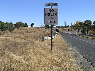
Rocky River is a locality in northern New South Wales, Australia near the town of Uralla on the Northern Tablelands plateau.

The Shire of Talbot and Clunes was a local government area about 160 kilometres (99 mi) northwest of Melbourne, the state capital of Victoria, Australia. The shire covered an area of 541.31 square kilometres (209.0 sq mi), and existed from 1915 until 1994.
The Goldfields region of Victoria is a region commonly used but typically defined in both historical geography and tourism geography. The region is also known as the Victorian Golden Triangle.

During the Australian gold rushes, starting in 1851, significant numbers of workers moved from elsewhere in Australia and overseas to where gold had been discovered. Gold had been found several times before, but the colonial government of New South Wales had suppressed the news out of the fear that it would reduce the workforce and so destabilise the economy.
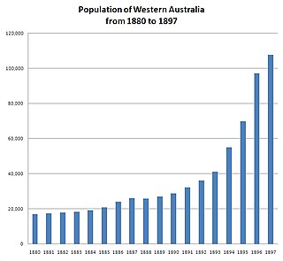
In the latter part of the nineteenth century, discoveries of gold at a number of locations in Western Australia caused large influxes of prospectors from overseas and interstate, and classic gold rushes. Significant finds included:

Barkly is a locality in Victoria, Australia, about 180 kilometres (110 mi) northwest of Melbourne. It is near the intersection of the road from Landsborough to Redbank, and the road from Frenchmans to St Arnaud. It is close to the west boundary of the St Arnaud Range National Park. It is located in the Pyrenees Shire. At the 2016 census Barkly had a population of 43.
Mafeking is a locality in Australia south-east of Grampians National Park and 20 km (12 mi) from the nearest town of Willaura.