
Central Goldfields Shire is a local government area in Victoria, Australia, located in the central part of the state. It covers an area of 1,533 square kilometres (592 sq mi) and, in June 2018 had a population of 13,209.

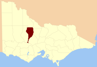
The Shire of Pyrenees is a local government area (LGA) in Victoria, Australia, located in the western part of the state. It covers an area of 3,435 square kilometres (1,326 sq mi) and in June 2018 had a population of 7,353.

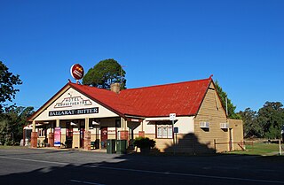
Avoca is a town in the Central Highlands of Victoria, Australia, 71 kilometres (44 mi) north west of Ballarat. It is one of two main towns in the Pyrenees Shire, the other being Beaufort to the south.

Homebush is a locality 10 kilometres (6 mi) from Avoca in central Victoria, Australia. It is located within the Pyrenees Shire.

Maryborough is a town in Victoria, Australia, on the Pyrenees Highway, 58 kilometres (36 mi) north of Ballarat and 168 kilometres (104 mi) northwest of Melbourne, in the Shire of Central Goldfields. At the 2016 census, it had a population of 7,921.
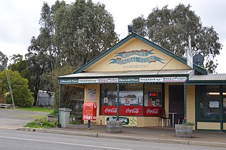
Amphitheatre is a small town in Victoria, Australia. It is located on the Pyrenees Highway in the Pyrenees Shire, south-west of Avoca. At the 2016 census, Amphitheatre and the surrounding area had a population of 248.

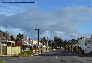
Dunolly is a town in Victoria, Australia, located on the Dunolly - Maryborough Road, in the Shire of Central Goldfields. At the 2016 census, Dunolly had a population of 893, down from 969 in 2006.

Bung Bong is a locality in Victoria between the towns of Avoca and Maryborough. The locality is divided, with the Western section in the Pyrenees Shire and the Eastern section in Shire of Central Goldfields. The Bet Bet Creek runs towards the north through the middle of the locality and then into the Loddon River. Bung Bong is located on the Pyrenees Highway.
The County of Gladstone is one of the 37 counties of Victoria which are part of the cadastral divisions of Australia, used for land titles. It is located between the Avoca River in the west and Loddon River and Bet Bet Creek in the east. The county was proclaimed in 1870.

Ripon is a single member electoral district of the Victorian Legislative Assembly. It is a rural electorate based in western Victoria. In 1946 the electoral district of Ripon was first contested but then abolished in the 1955 election after being held by Labor for seven of these years. Ripon was re-created in 1976, essentially as a replacement for Hampden.

The Shire of Bet Bet was a local government area located about 180 kilometres (112 mi) northwest of Melbourne, the state capital of Victoria, Australia. The shire covered an area of 928.2 square kilometres (358.4 sq mi), and existed from 1861 until 1995.

The Shire of Avoca was a local government area about 180 kilometres (112 mi) northwest of Melbourne, the state capital of Victoria, Australia. The shire covered an area of 1,124 square kilometres (434.0 sq mi), and existed from 1861 until 1994.

The Maryborough–Avoca–Ararat railway is a railway line in western Victoria, Australia. It is one of the few railway lines in the state to have been closed and then reopened. Today it is a standard gauge branch line connecting the Western SG with Bung Bong (ballast) and Dunolly (grain), running through Maryborough station.

Timor (/ˈtaɪˈmɔː/), also known as Timor-Bowenvale, is a mainly rural area in the Central Goldfields Shire of Victoria, Australia. It is located 8 kilometres (5 mi) north of Maryborough, Victoria and 178 kilometres (111 mi) northwest of Melbourne, the state capital.
Natte Yallock is a locality in the Australian state of Victoria. Natte Yallock is located in the Pyrenees Shire local government area, 200 km north-west of the state capital, Melbourne, and 90 km from the regional cities of Bendigo and Ballarat. At the 2006 census, Natte Yallock and the surrounding area had a population of 188.
Bealiba is a town in the Australian state of Victoria. The town is located in the Central Goldfields Shire local government area, 207 kilometres (129 mi) north-west of the state capital, Melbourne, and 74 kilometres (46 mi) from the regional city of Bendigo. At the 2011 census, Bealiba and the surrounding area had a population of 300.
Ben Nevis railway station is an abandoned station on the Avoca railway line, a railway line running from Ararat to Avoca and onto Maryborough in the Australian state of Victoria. It also acted as the terminus of the abandoned Navarre railway line to Navarre, a community in the Wimmera region of Victoria, which was closed in 1954.
Nelson Province was an electorate of the Victorian Legislative Council (Australia). It was created in the wide-scale redistribution of Provinces 1882 when Central and Eastern Provinces were abolished and ten new Provinces were created. Its area included Camperdown, Ararat and Mortlake.
Moonambel is a town in the Pyrenees region of the Australian state of Victoria, situated along the Stawell-Avoca Road [about 8 kilometres (5.0 mi) from the junction with the Sunraysia Highway]. The town is located in the Pyrenees Shire Local Government Area, near the heart of the Pyrenees wine region. The name 'Moonambel' is believed to be an aboriginal word meaning 'hollow in the hills'.
Wareek is a Central Victorian locality which straddles both the Pyrenees Shire and the Shire of Central Goldfields.


