Hullapur is a village in Sareni block of Rae Bareli district, Uttar Pradesh, India. It is located 20 km from Lalganj, the tehsil headquarters. As of 2011, it has a population of 1,864 people, in 355 households. It has one primary school and no healthcare facilities.

Paraura is a village in Rahi block of Rae Bareli district, Uttar Pradesh, India. It is located 13 km from Rae Bareli, the district headquarters. As of 2011, it has a total population of 1,060 people, in 191 households. It has one primary school and no medical facilities and it does not host a weekly haat or a permanent market. It belongs to the nyaya panchayat of Bhaon.
Raghunathpur is a village in Rahi block of Rae Bareli district, Uttar Pradesh, India. It is located 11 km from Rae Bareli, the district headquarters. As of 2011, it has a total population of 1,217 people, in 207 households. It has one primary school and no medical facilities and it does not host a weekly haat or a permanent market. It belongs to the nyaya panchayat of Bhadokhar.
Raipur Maheri is a village in Rahi block of Rae Bareli district, Uttar Pradesh, India. It is located 10 km from Rae Bareli, the district headquarters. As of 2011, it has a total population of 1,753 people, in 314 households. It has one primary school and no medical facilities and it does not host a weekly haat or a permanent market. It belongs to the nyaya panchayat of Bhadokhar.
Paintemau is a village in Rahi block of Rae Bareli district, Uttar Pradesh, India. It is located 6 km from Rae Bareli, the district headquarters. As of 2011, it has a total population of 617 people, in 112 households. It has one primary school and no medical facilities and it does not host a weekly haat or a permanent market. It belongs to the nyaya panchayat of Rustampur.
Saidanpur is a village in Rahi block of Rae Bareli district, Uttar Pradesh, India. It is located 9 km from Rae Bareli, the district headquarters. As of 2011, it has a total population of 1,854 people, in 330 households. It has one primary school and no medical facilities and it hosts a permanent market but not a weekly haat. It belongs to the nyaya panchayat of Khagipur Sandwa.
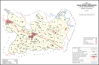
Gaimau is a village in Jagdishpur block of Sultanpur district, Uttar Pradesh, India. It is located 50 km from Sultanpur, the district headquarters. As of 2011, it has a population of 1,617 people, in 255 households. It has one primary school and no healthcare facilities and does not host a permanent market or weekly haat. It belongs to the nyaya panchayat of Harimau.

Muradabad is a village in Akhand Nagar block of Kadipur tehsil in Sultanpur district, Uttar Pradesh, India. As of 2011, it has a population of 1,543 people, in 238 households. It has one primary school and no healthcare facilities and it hosts both a regular market and a weekly haat. It belongs to the nyaya panchayat of Sajampur.
Raipur is a village in Akhand Nagar block of Kadipur tehsil in Sultanpur district, Uttar Pradesh, India. As of 2011, it has a population of 1,738 people, in 307 households. It has one primary school and no healthcare facilities and it does not host a regular market or a weekly haat. It belongs to the nyaya panchayat of Sajampur.
Ramnagar is a village in Akhand Nagar block of Kadipur tehsil in Sultanpur district, Uttar Pradesh, India. As of 2011, it has a population of 983 people, in 144 households. It has no healthcare facilities and it does not host a regular market or a weekly haat. It belongs to the nyaya panchayat of Sajampur.

Daulatpur is a village in Kadipur block of Kadipur tehsil in Sultanpur district, Uttar Pradesh, India. As of 2011, it has a population of 1,261 people, in 172 households. It has one primary school and no healthcare facilities and it does not host a regular market or a weekly haat. It belongs to the nyaya panchayat of Kalikapur Kalan.

Daulatpur is a village in Jaisinghpur block of Sultanpur district, Uttar Pradesh, India. As of 2011, it has a population of 974 people, in 169 households. It has one primary school and no healthcare facilities and it does not host a permanent market or weekly haat. It belongs to the nyaya panchayat of Saraiya.

Biswan is a village in Gauriganj block of Amethi district, Uttar Pradesh, India. As of 2011, it has a population of 353 people, in 55 households. It has no schools and no healthcare facilities and hosts both a permanent market and a weekly haat. It belongs to the nyaya panchayat of Semuai.
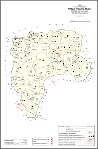
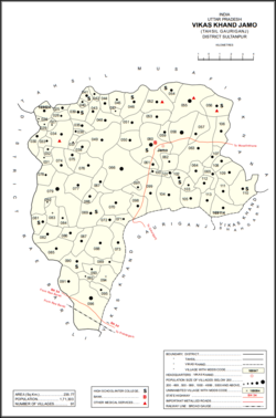
Jamo, also spelled Jamun or Jamon, is a village and community development block headquarters in Gauriganj tehsil of Amethi district, Uttar Pradesh, India. As of 2011, it has a population of 6,734 people, in 1,182 households. It was historically the capital of the pargana of Gaura Jamun. It is located at the intersection of four minor district roads, some of which are prone to flooding during the rainy season.
Gaura is a village in Jamo block of Amethi district, Uttar Pradesh, India. The namesake of the historical pargana of Gaura Jamun, Gaura consists of a main site called Gaura khas in the northeast surrounded by several smaller hamlets. The village lands are fertile and contain many orchard groves. In the east-central part there is a large jhil which provides a convenient source of irrigation but also sometimes overflows and floods the surrounding fields. Gaura is located just north of Jamo on the Gauriganj-Jagdishpur road, and another road also leads off to Musafirkhana.
Katari is a village in Jamo block of Amethi district, Uttar Pradesh, India. It is located by a stream called the Naiya or Kandu nala, which flows east toward the Gomti river. The main highway from Lucknow to Jaunpur passes further north. Katari was historically the seat of a taluqdari estate held by a leading branch of the Kanhpuria Rajputs.
Baraulia is a village in Jamo block of Amethi district, Uttar Pradesh, India. As of 2011, it has a population of 3,878 people, in 691 households. It has one primary school and no healthcare facilities and it hosts both a regular market and a weekly haat. It belongs to the nyaya panchayat of Hardo.
Bakhshgarh is a village in Jamo block of Amethi district, Uttar Pradesh, India. As of 2011, it has a population of 1,628 people, in 275 households. It has one primary school and no healthcare facilities and it does not host a weekly haat or a permanent market. It belongs to the nyaya panchayat of Mawai.
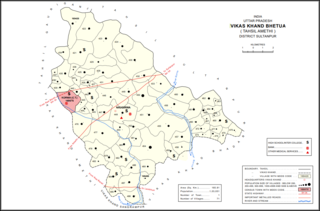
Piparpur is a village in Bhetua block of Amethi district, Uttar Pradesh, India. As of 2011, it has a population of 1,025 people, in 186 households. It has one primary school and no healthcare facilities and hosts a weekly haat but not a permanent market. It belongs to the nyaya panchayat of Amey Maphi.
Naugirwa is a village in Bhetua block of Amethi district, Uttar Pradesh, India. As of 2011, it has a population of 1,168 people, in 220 households. It has one primary school and a veterinary hospital and hosts a weekly haat but not a permanent market. It belongs to the nyaya panchayat of Darai Mafi.