Glenageary is an area in the suburbs of Dún Laoghaire–Rathdown, Ireland. While there is no officially defined boundary, it is surrounded by the areas of Dalkey, Dún Laoghaire, Glasthule, Johnstown, Killiney and Sallynoggin. The Church of Ireland does have a defined boundary for the Parish of Glenageary.

Blackrock is an affluent suburb of Dublin, Ireland, 3 km (1.9 mi) northwest of Dún Laoghaire. It is named after the local geological rock formation to be found in the area of Blackrock Park. In the late 18th century, the Blackrock Road was a common place for highway robberies. The Blackrock baths, provided for by the railway company in 1839, became popular in the 19th century but Blackrock is now a tourist destination.

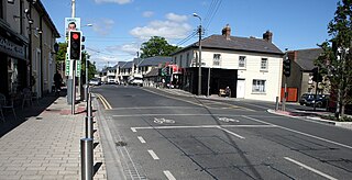
Dalkey is a village in Dún Laoghaire–Rathdown county southeast of Dublin, Ireland. It was founded as a Viking settlement and became a port in the Middle Ages. According to chronicler John Clyn (c.1286–c.1349), it was one of the ports through which the plague entered Ireland in the mid-14th century.

Dún Laoghaire–Rathdown is a county in Ireland. It is in the province of Leinster and the Eastern and Midland Region. It is one of three successor counties to County Dublin, which was disestablished in 1994. It is named after the former borough of Dún Laoghaire and the barony of Rathdown. Dún Laoghaire–Rathdown County Council is the local authority for the county. The population of the county was 233,860 at the time of the 2022 census.

Killiney is an affluent suburb in the southern coastal part of County Dublin, Ireland. It lies south of Dalkey, east and northeast of Ballybrack and Sallynoggin and north of Shankill. The place grew around the 11th century Killiney Church, and became a popular seaside resort in the 19th century. The area is notable for some famous residents, including two members of U2, and Enya.
Cabinteely is a suburb of Dublin's southside. It is in Dún Laoghaire–Rathdown, County Dublin, Ireland. The population of all electoral divisions labelled as Cabinteely was 15,864 as of the 2022 census.

Dún Laoghaire is a parliamentary constituency represented in Dáil Éireann, the lower house of the Irish parliament or Oireachtas. The constituency elects 4 deputies on the system of proportional representation by means of the single transferable vote (PR-STV).
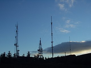
Three Rock Mountain is a mountain in Co Dublin, Ireland. It is 444 metres high and forms part of the group of hills in the Dublin Mountains which comprises Two Rock, Three Rock, Kilmashogue and Tibradden Mountains. The mountain takes its name from the three groups of granite rocks at the summit. It was once believed that these features were man-made: for instance, Gabriel Beranger wrote of them in 1780, "I take them to be altars upon which sacrifices were offered […] the regularity which is observed in piling them convinces me they are the work of man, as they could not grow in that position". In fact, the three outcrops are tors: natural geological features produced by the gradual process of weathering. Today, the summit is dominated by the many radio masts and towers that use the site to broadcast their signals across the Dublin area below. The forestry plantations on the slopes consist mainly of Sitka spruce, Japanese larch, Scots pine, Monterey pine and lodgepole pine.

Sandycove and Glasthule railway station serves the suburban areas of Sandycove and Glasthule in Dún Laoghaire–Rathdown, Ireland.

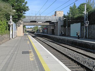
Dalkey railway station is a railway station that serves Dalkey in Dún Laoghaire–Rathdown, Ireland.

Dún Laoghaire–Rathdown County Council is the local authority of the county of Dún Laoghaire–Rathdown, Ireland. It is one of three local authorities that succeeded the former Dublin County Council on its abolition on 1 January 1994 and one of four councils in the old County Dublin. As a county council, it is governed by the Local Government Act 2001. The council is responsible for housing and community, roads and transportation, urban planning and development, amenity and culture, and environment. The council has 40 elected members. Elections are held every five years and are by single transferable vote. The head of the council has the title of Cathaoirleach (chairperson). The county administration is headed by a chief executive, Frank Curran. The county town is Dún Laoghaire. It serves a population of approximately 206,260.
Dalkey Quarry is a long-disused 19th century granite quarry located on Dalkey Hill in the Dublin suburb of Dalkey, which was used to build several large maritime structures in south Dublin. Since passing into public ownership in the early 20th century and becoming part of Killiney Hill Park, it has become one of the most important rock climbing venues in Ireland, with over 350 graded routes, some of which are amongst the hardest single-pitch rock climbs in the country such as Indecent Assault. The climbs are all traditional climbing routes and no bolted sport climbing routes are permitted, although some metal pegs are tolerated on the most extreme routes.

John Bailey was an Irish Fine Gael politician who was a member of Dún Laoghaire–Rathdown County Council. He spent 10 years as chairman of the Dublin County Board of the Gaelic Athletic Association.
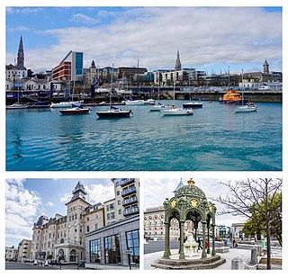
Dún Laoghaire is a suburban coastal town in County Dublin in Ireland. It is the administrative centre of the county of Dún Laoghaire–Rathdown. The town was built up alongside a small existing settlement following 1816 legislation that allowed the building of a major port to serve Dublin. It was known as Dunleary until it was renamed Kingstown in honour of King George IV's 1821 visit, and in 1920 was given its present name, the original Irish form from which "Dunleary" was anglicised. Over time, the town became a residential location, a seaside resort, the terminus of Ireland's first railway and the administrative centre of the former borough of Dún Laoghaire, and from 1994, of the county of Dún Laoghaire–Rathdown.

The R119 road is a regional road in Dún Laoghaire–Rathdown, Ireland.

Carrickgollogan is a hill in Dún Laoghaire–Rathdown in Ireland, towards the southern border of the traditional County Dublin. It is 276 metres high, on the eastern edge of the Dublin Mountains, rising above the districts of Rathmichael and Shankill. Its summit is noted for the panoramic views it offers of south Dublin and north Wicklow.

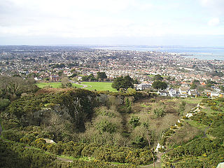
Killiney Hill is the southernmost of the two hills which form the southern boundary of Dublin Bay, the other being Dalkey Hill. These two hills form part of Killiney Hill Park.

Rathdown is the south-easternmost barony in County Dublin, Ireland. It gives its name to the county of Dún Laoghaire–Rathdown. Before County Wicklow was shired in 1606, Rathdown extended further south: it was named after a medieval settlement which grew up around Rathdown Castle, at a site subsequently deserted and now in County Wicklow in the townland of Rathdown Upper, north of Greystones. The Wicklow barony of Rathdown corresponds to the portion transferred to the new county; although both divisions were originally classed as "half baronies", in the nineteenth century the distinction between a barony and a half barony was obsolete.

Killiney Castle, also known as Mount Malpas, Rocksborough, or Loftus Hill, and now known as Fitzpatrick Castle Hotel, is an 18th-century manor house near Killiney in County Dublin, Ireland. Subsequently converted into a hotel, it has operated as one since 1971.

Barnacullia quarries, is a granite quarrying area in the townland of Barnacullia on the north-eastern slopes of Three Rock Mountain in the county of Dún Laoghaire–Rathdown, Ireland.

