Turlough Hill, also known as Tomaneena, is a 681-metre-high (2,234 ft) mountain in County Wicklow in Ireland and site of Ireland's only pumped-storage hydroelectricity plant. The power station is owned and operated by the ESB and can generate up to 292 megawatts (392,000 hp) of electricity at times of peak demand.
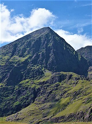
Carrauntoohil, Carrauntoohill or Carrantuohill is the highest mountain in Ireland at 1,038.6 metres. It is on the Iveragh Peninsula in County Kerry, close to the centre of Ireland's highest mountain range, MacGillycuddy's Reeks. Carrauntoohil is composed mainly of sandstone, whose glaciation produced distinctive features on the mountain such as the Eagle's Nest corrie and some deep gullies and sharp arêtes in its east and northeastern faces that are popular with rock and winter climbers.

In topography, prominence or relative height measures the height of a mountain or hill's summit relative to the lowest contour line encircling it but containing no higher summit within it. It is a measure of the independence of a summit. The key col ("saddle") around the peak is a unique point on this contour line and the parent peak is some higher mountain, selected according to various criteria.

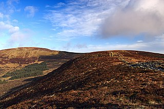
Slieve Croob is a mountain with a height of 534 metres (1,752 ft) in the middle of County Down, Northern Ireland. It is the heart of a mountainous area, the Dromara Hills, north of the Mourne Mountains. It is designated an Area of Outstanding Natural Beauty and is the source of the River Lagan. There is a small road to the summit, where there is an ancient burial cairn and several transmitter stations with radio masts. It has wide views over all of County Down and further afield. The Dromara Hills also includes Slievenisky, Cratlieve, Slievegarran and Slievenaboley.
In these lists of mountains in Ireland, those within Northern Ireland, or on the Republic of Ireland – United Kingdom border, are marked with an asterisk, while the rest are within the Republic of Ireland. Where mountains are ranked by height, the definition of the topographical prominence used to classify the mountain, is noted. In British definitions, a height of 600 metres (1,969 ft) is required for a mountain, whereas in Ireland, a lower threshold of 500 metres (1,640 ft) is sometimes advocated.

Mount Brandon or Brandon, at 952 metres (3,123 ft), is one of the ten highest peaks in Ireland, being the 8th–highest peak in Ireland on the Arderin list, and the 9th–highest on the Vandeleur-Lynam list. Brandon is the highest Irish mountain outside the MacGillycuddy's Reeks range and has the greatest prominence of any Irish peak except Carrauntoohil, Ireland's highest mountain.

Slieve Donard is the highest mountain in Northern Ireland, the highest in Ulster and the seventh-highest in Ireland, with a height of 850 metres (2,790 ft). The highest of the Mourne Mountains, it is near the town of Newcastle on the eastern coast of County Down, overlooking the Irish Sea. It is also the highest mountain in the northern half of Ireland.

Lugnaquilla is the highest of the Wicklow Mountains in Ireland, rising to 925 metres (3,035 ft). It is also the highest Irish mountain outside of County Kerry, and the highest point in County Wicklow and the province of Leinster. Lugnaquilla overlooks the Glen of Imaal to the west and Glenmalure to the east.

Galtymore or Galteemore is a mountain in the province of Munster, Ireland. At 917.9 metres, it is one of Ireland's highest mountains, being the 12th-highest on the Arderin list, and 14th-highest on the Vandeleur-Lynam list. Galtymore has the 4th-highest topographic prominence of any peak in Ireland, which classifies Galtymore as a P600, or "major mountain". It is one of the 13 Irish Munros.

The mountains and hills of the British Isles are categorised into various lists based on different combinations of elevation, prominence, and other criteria such as isolation. These lists are used for peak bagging, whereby hillwalkers attempt to reach all the summits on a given list, the oldest being the 282 Munros in Scotland, created in 1891.
Djouce at 725 metres (2,379 ft), is the 74th–highest peak in Ireland on the Arderin scale, and the 91st–highest peak on the Vandeleur-Lynam scale. Djouce is situated in the northeastern section of the Wicklow Mountains, and dominates the views of the Wicklow Mountains from Roundwood to Newtownmountkennedy. Djouce is one of a few Irish mountains for which the Irish Office of Public Works (OPW) maintain a boarded mountain trail, using railway sleepers, from its base to a point close to its summit; making the mountain even more accessible to the public, but while also protecting the underlying bog and soil from human erosion. Djouce is popular with hill walkers, and it lies along the 131-kilometre Wicklow Way; on its southern slopes at a scenic viewpoint is the J.B. Malone memorial stone, dedicated to the creator of the Wicklow Way.

Mullaghcleevaun at 849 metres (2,785 ft), is the 15th–highest peak in Ireland on the Arderin scale, and the 20th–highest peak on the Vandeleur-Lynam scale. Mullaghcleevaun is in the central sector of the Wicklow Mountains range, in Wicklow, Ireland; it is the 2nd highest peak in Wicklow after Lugnaquilla. Mullaghcleevaun lies on the main "central spine" of the whole range that runs from Kippure in the north, to Lugnaquillia in the south; and in particular, it lies on the continuous "central boggy ridge" that runs from the Sally Gap to Tonelagee.

Mangerton or Mangerton Mountain, at 838 metres (2,749 ft), is the 19th-highest peak in Ireland on the Arderin list, and the 26th–highest mountain according to the Vandeleur-Lynam list. Mangerton is the tallest mountain in the Mangerton Mountain Group, also called the Mangerton Mountains or the Mountains of East Kerry, a range that includes five other major mountains that have a height above 2,000 feet (610 m). Mangerton's western slopes lie within the Killarney National Park. On Mangerton's north-western face lies a deep corrie lake called the Devil's Punchbowl, which is a popular scenic destination for hill walkers; although the mountain is often overlooked by walkers due to the proximity of its more scenic and accessible neighbour, Torc Mountain. The far northern slopes of Mangerton was the site of an important 13th-century battle between the Mac Cárthaigh, and the FitzGeralds, known as the "Tooreencormick battle site".

Baurtregaum at 851 metres (2,792 ft), is the 13th–highest peak in Ireland on the Arderin scale, and the 18th–highest peak on the Vandeleur-Lynam scale. Baurtregaum is situated at the centre of the massif of the Slieve Mish Mountains on the Dingle Peninsula in County Kerry, Ireland. It is the tallest mountain of the Slieve Mish range, with a number of major subsidiary summits.

Binn idir an Dá Log, sometimes anglicized Benadolug, at 702 metres (2,303 ft), is the highest of the Maumturk Mountains in Connemara in County Galway, Ireland. It is at the middle of the long north-west to south-east central spine of the range. The summit is the 87th-highest peak in Ireland on the Arderin list, and the 108th-highest on the Vandeleur-Lynam list.

Caherconree at 835 metres (2,740 ft), is the 20th–highest peak in Ireland on the Arderin scale, and the 27th–highest peak on the Vandeleur-Lynam scale. Caherconree is the 2nd-highest mountain in the Slieve Mish Mountains in the Dingle Peninsula in County Kerry, Ireland, and one of its southerly spurs is the site of an ancient stone promontory fort, which is a protected National Monument.
The Slieveardagh Hills are a low range of hills on the County Tipperary - Kilkenny border, mainly in the Tipperary barony of Slievardagh. The highest point is Clomantagh Hill at 349 m and the highest point by relative height in the hills is Knocknamuck at 340m with prominence of 268m. The hills contain the source of the River Goul, which flows north and the Kings River which flows southwards from the hills.

Cupidstown Hill, at 379 metres (1,243 ft), is the highest point in County Kildare, Ireland, and lies on the fringes of the Wicklow Mountains, 11.6 kilometres (7.2 mi) east of Naas.

Gravale at 718 metres (2,356 ft), is the 79th–highest peak in Ireland on the Arderin scale, and the 98th–highest peak on the Vandeleur-Lynam scale. Gravale is in the middle sector of the Wicklow Mountains range, in County Wicklow, Ireland. Gravale sits on a north-east to south-west "boggy ridge" that forms the "central spine" of the whole range, which runs from the Sally Gap, to Carrigvore 682 metres (2,238 ft), to Gravale, and after a col to Duff Hill 720 metres (2,360 ft), which is part of the larger massif of Mullaghcleevaun 849 metres (2,785 ft).

Croaghanmoira at 664 metres (2,178 ft), is the 136th–highest peak in Ireland on the Arderin scale, and the 165th–highest peak on the Vandeleur-Lynam scale. Croaghanmoira is situated in the far south-east corner of the Wicklow Mountains range, and sits on its own small massif with several other lesser but well known peaks, separated from the nearby larger massif of Lugnaquilla by the Laragh to Aghavannagh road; the summit of Croaghanmoira has a distinctive "pyramidal" profile.