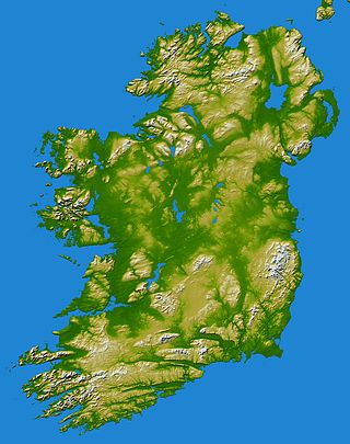
County Carlow is a county located in the Southern Region of Ireland, within the province of Leinster. Carlow is the second smallest and the third least populous of Ireland's 32 traditional counties. Carlow County Council is the governing local authority.
In these lists of mountains in Ireland, those within Northern Ireland, or on the Republic of Ireland – United Kingdom border, are marked with an asterisk, while the rest are within the Republic of Ireland. Where mountains are ranked by height, the definition of the topographical prominence used to classify the mountain, is noted. In British definitions, a height of 600 metres (1,969 ft) is required for a mountain, whereas in Ireland, a lower threshold of 500 metres (1,640 ft) is sometimes advocated.

Borris is a village on the River Barrow, in County Carlow, Ireland. It lies on the R702 regional road.
Gulladuff is a small village and townland in County Londonderry, Northern Ireland. In the 2001 Census it had a population of 405 people. It is situated within Mid-Ulster District.

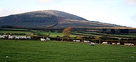
Mount Leinster is a 794-metre-high (2,605 ft) mountain in the Republic of Ireland. It straddles the border between Counties Carlow and Wexford, in the province of Leinster. It is the fifth-highest mountain in Leinster after Lugnaquilla 925 metres (3,035 ft), Mullaghcleevaun 849 metres (2,785 ft), Tonelagee 817 metres (2,680 ft), and Cloghernagh 800 metres (2,600 ft), and the highest of the Blackstairs Mountains. A 2RN transmission site tops the peak with a mast height of 122 metres (400 ft).

Rock is a small village in east County Tyrone, Northern Ireland located approximately 5 miles south-west of Cookstown. The village and surrounding area is located mainly within the parish of Desertcreat.
James Corcoran was an Irish rebel leader who following the suppression of the United Irish insurrection of 1798, maintained a guerrilla resistance to the British Crown forces in counties Wexford and Kilkenny until his final defeat and death in 1804.

Ciste Dhubh is a mountain in the Scottish Highlands, between Glen Shiel and Glen Affric. With a height of 979 metres (3,212 ft), it is classed as a Munro. It is almost surrounded by glens: Fionngleann (north), An Caorann Mòr (east) and Allt Cam-bàn (west), with the Bealach a' Chòinich pass (south) linking it to the mountain of Sgùrr an Fhuarail. Its name comes from Scottish Gaelic A' Chiste Dhubh, "the black chest", possibly referring to the dark rocky summit.

Rathnure is a small village on the R731 regional road about 12 km (7.5 mi) from the town of Enniscorthy, County Wexford, Ireland. The village is located at the foot of the Blackstairs Mountain, which borders County Carlow on the opposite side.

Cloghduv or Cloghduff is a village in County Cork, Ireland. It has a population of 440 people. The main industry is agriculture, although it is also a commuter village for Cork City. Cloughduv is part of the Dáil constituency of Cork North-West. The village is 1.4 km from the River Bride.
The Blackstairs Mountains run roughly north/south along the border between County Carlow and County Wexford in Ireland. The highest peak is Mount Leinster with a total height of 2612 ft/ 796 metres.

Kiltealy is a small village in the southeastern corner of Ireland. It is situated on the foothills of the Blackstairs Mountains in County Wexford at the junction of the R702 and R730 regional roads, on the eastern flank of the Blackstairs Mountains. The previous spelling was Cill Teidhile which means the Chapel/cemetery of Teidhil. Teidhil would most likely be the a first name although no longer in use as such.

Blackstairs Mountain is the second-highest mountain in the Blackstairs Mountains of southern Leinster in the Republic of Ireland. The mountain stretches from Rathgeran to Gowlin at Cathaoirs Den.

New Ross Golf Club is an Irish golf club founded in 1905 and based in Tinneranny, New Ross, County Wexford, Ireland. The club's slogan is "A Pleasure to Play".

Croaghaun is a mountain in County Carlow, Ireland, one of the Blackstairs Mountains.

The South Leinster Way is a long-distance trail in Ireland. It is 104 kilometres long and begins in Kildavin, County Carlow and runs through County Kilkenny before ending in Carrick-on-Suir, County Tipperary. It is typically completed in five days. It is designated as a National Waymarked Trail by the National Trails Office of the Irish Sports Council and is jointly managed by Carlow County Council, Kilkenny County Council, Tipperary County Council, Carlow Local Sports Partnership, Kilkenny Trails and Coillte. It was opened on 30 November 1985 by Donal Creed, Minister of State for Sport.
St Mullin's is a Gaelic Athletic Association club located on the banks of the river Barrow beneath the Blackstairs mountains in St Mullin's, County Carlow, Ireland. The club, founded in 1914, primarily involves hurling.

Altamont House is a historic building best known for its ornamental gardens in County Carlow. The Robinsonian-style gardens are often referred to as "the jewel in Ireland's gardening crown".
Carrick is a civil parish in County Westmeath, Ireland. It is located about 8.47 kilometres (5 mi) south of Mullingar.

Carrick is a village located within the civil parish of Glencolmcille in County Donegal, Ireland. As of the 2016 census, the population of the village was 265. Carrick is located between neighbouring towns Glencolmcille, Meenanary, Teelin and Kilcar. Nearby is Sliabh Liag, the highest sea cliff in Europe.