Glendalough is a glacial valley in County Wicklow, Ireland, renowned for an Early Medieval monastic settlement founded in the 6th century by St Kevin. From 1825 to 1957, the head of the Glendalough Valley was the site of a galena lead mine. Glendalough is also a recreational area for picnics, for walking along networks of maintained trails of varying difficulty, and also for rock-climbing.
These are lists of long-distance trails in Ireland, and include recognised and maintained walking trails, pilgrim trails, cycling greenways, boardwalk-mountain trails, and interconnected national and international trail systems.

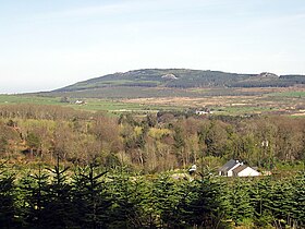
Bray Head is a 241 m (791 ft) hill and headland located in northern County Wicklow, Ireland, between the towns of Bray and Greystones. It forms part of the Wicklow Mountains and is a popular spot with hillwalkers. At the top of the head is a concrete cross which was placed there in 1950 during the holy year. Every Good Friday, hundreds of local people climb to the top of the head in a Good Friday procession marking the stations of the Cross as they go along, with the final station being held at the holy year cross. The headland and adjacent lands were designated under a Special Amenity Area Order in March 2008.

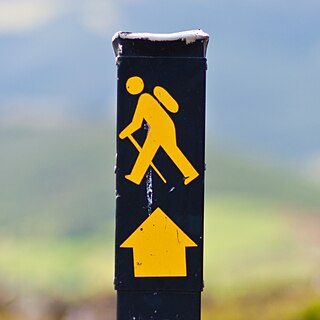
The Wicklow Way is a 131-kilometre (81-mile) long-distance trail that crosses the Wicklow Mountains in Ireland. It runs from Marlay Park in the southern suburbs of Dublin through County Wicklow and ends in the village of Clonegal in County Carlow. It is designated as a National Waymarked Trail by the Irish Sports Council and is waymarked by posts with a yellow "walking man" symbol and a directional arrow. Typically completed in 5–7 days, it is one of the busiest of Ireland's National Waymarked Trails, with up to 24,000 people a year walking the most popular sections. The Way is also used regularly by a number of mountain running competitions.

Lugnaquilla, at 925 metres (3,035 ft), is the 11th–highest peak in Ireland on the Arderin list, and 13th–highest on the Vandeleur-Lynam list, and the highest Irish mountain outside of Kerry. Lugnaquilla is the highest point in Wicklow, and in the province of Leinster. Lugnaquilla is in the Wicklow Mountains, and overlooks the Glen of Imaal to the west and Glenmalure to the east.

Glenmalure is a 20-kilometre long U-shaped glacial valley in the Wicklow Mountains in Ireland. Glenmalure is an important base for climbing in the Wicklow mountains, and particularly accessing the massif of Lugnaquilla, and contains one of the earliest An Oige youth hostels in Ireland. Glenmalure was also an important historical area and the site of the Battle of Glenmalure in 1580, as well as various events in the Irish Rebellion of 1798.
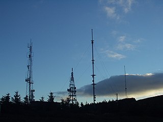
Three Rock Mountain is a mountain in Co Dublin, Ireland. It is 444 metres high and forms part of the group of hills in the Dublin Mountains which comprises Two Rock, Three Rock, Kilmashogue and Tibradden Mountains. The mountain takes its name from the three groups of granite rocks at the summit. It was once believed that these features were man-made: for instance, Gabriel Beranger wrote of them in 1780, "I take them to be altars upon which sacrifices were offered […] the regularity which is observed in piling them convinces me they are the work of man, as they could not grow in that position". In fact, the three outcrops are tors: natural geological features produced by the gradual process of weathering. Today, the summit is dominated by the many radio masts and towers that use the site to broadcast their signals across the Dublin area below. The forestry plantations on the slopes consist mainly of Sitka spruce, Japanese larch, Scots pine, Monterey pine and lodgepole pine.

Kippure at 757 metres (2,484 ft), is the 56th-highest peak in Ireland on the Arderin scale, and the 72nd-highest peak on the Vandeleur-Lynam scale. Kippure is situated in the far northern sector of the Wicklow Mountains, where it lies on the border of the counties of Dublin and Wicklow in Ireland. Kippure is the County Top for Dublin, and its height and positioning over Dublin city have made its summit an important site for transmission masts, which are highly visible from a distance. Kippure's slopes feed into the Liffey Head Bog which forms the source of the River Liffey. The summit can be easily accessed from the east via a path that lies off the R115 road along the route to the Sally Gap.

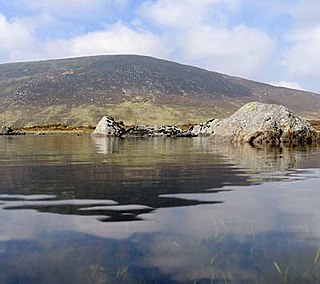
Luggala, also called Fancy Mountain at 595 metres (1,952 ft), is the 230th-highest peak in Ireland on the Arderin scale. Being below 600 metres (2,000 ft), it does not rank on the Vandeleur-Lynam or Hewitt scales. Luggala is in the northeastern section of the Wicklow Mountains in Ireland, and overlooks the Lough Tay, which lies at the base of the steep granite cliffs on Luggala's eastern face. As well as a noted scenic point in County Wicklow, Luggala's eastern cliffs have many graded rock-climbing routes.
Djouce at 725 metres (2,379 ft), is the 74th–highest peak in Ireland on the Arderin scale, and the 91st–highest peak on the Vandeleur-Lynam scale. Djouce is situated in the northeastern section of the Wicklow Mountains, and dominates the views of the Wicklow Mountains from Roundwood to Newtownmountkennedy. Djouce is one of a few Irish mountains for which the Irish Office of Public Works (OPW) maintain a boarded mountain trail, using railway sleepers, from its base to a point close to its summit; making the mountain even more accessible to the public, but while also protecting the underlying bog and soil from human erosion. Djouce is popular with hill walkers, and it lies along the 131-kilometre Wicklow Way; on its southern slopes at a senic viewpoint is the J.B. Malone memorial stone, dedicated to the creator of the Wicklow Way.

Mullaghcleevaun at 849 metres (2,785 ft), is the 15th–highest peak in Ireland on the Arderin scale, and the 20th–highest peak on the Vandeleur-Lynam scale. Mullaghcleevaun is in the central sector of the Wicklow Mountains range, in Wicklow, Ireland; it is the 2nd highest peak in Wicklow after Lugnaquilla. Mullaghcleevaun lies on the main "central spine" of the whole range that runs from Kippure in the north, to Lugnaquillia in the south; and in particular, it lies on the continuous "central boggy ridge" that runs from the Sally Gap to Tonelagee.

Tonelagee at 817 metres (2,680 ft), is the 25th–highest peak in Ireland on the Arderin scale, and the 33rd–highest peak on the Vandeleur-Lynam scale. Tonelagee is situated in the central sector of the Wicklow Mountains range, and sits on the main "central spine" of the range that runs from Kippure in the north, to Lugnaquillia in the south; and in particular, the continuous "central boggy ridge" that runs from the Sally Gap in the north, via Mullaghcleevaun, to Tonelagee. Tonelagee is the third highest peak in Wicklow after Lugnaquilla and Mullaghcleevaun.

Camaderry at 699 metres (2,293 ft), is the 90th-highest peak in Ireland on the Arderin scale, and the 112th-highest peak on the Vandeleur-Lynam scale. Camaderry is situated in the southern sector of the Wicklow Mountains range, and forms a broad horseshoe around the valley of Glendalough with the hydroelectric station at Turlough Hill 681 metres (2,234 ft), and the mountains of Conavalla 734 metres (2,408 ft), and Lugduff 652 metres (2,139 ft). Camaderry has a subsidiary summit, Camaderry South East Top 677 metres (2,221 ft), and both lie across the deep Wicklow Gap from Tonelagee 817 metres (2,680 ft), which sits on the "central spine" of the Wicklow range.

Tibradden Mountain is a mountain in County Dublin in Ireland. Other former names for the mountain include "Garrycastle" and "Kilmainham Begg". It is 467 metres high and is the 561st highest mountain in Ireland. It forms part of the group of hills in the Dublin Mountains which comprises Two Rock, Three Rock, Kilmashogue and Tibradden Mountains. The views from the summit encompass Dublin to the north, Two Rock to the east and the Wicklow Mountains to the south and west. The geological composition is mainly granite and the southern slopes are strewn with granite boulders. The summit area is a habitat for heather, furze, gorse and bilberry as well as Sika deer, foxes and badgers. The forestry plantation on the slopes – known as the Pine Forest – contains Scots pine, Japanese larch, European larch, Sitka spruce, oak and beech. The mountain is also a site of archaeological interest with a prehistoric burial site close to the summit.
Cloghernagh at 800 metres (2,600 ft), does not have the prominence to qualify as an Arderin, but does have the prominence to be the 40th–highest peak on the Vandeleur-Lynam scale. Cloghernagh is situated in the southern sector of the Wicklow Mountains range, and is part of the large massif of Lugnaquilla 925 metres (3,035 ft), Wicklow's highest mountain.
Two Rock is a mountain in Dún Laoghaire–Rathdown, Ireland. It is 536 metres high and is the 382nd highest mountain in Ireland. It is the highest point of the group of hills in the Dublin Mountains which comprises Two Rock, Three Rock, Kilmashogue and Tibradden Mountains. The mountain takes its name from the two granite tors that lie to the south-east of the summit. From the summit, which is called Fairy Castle, there are views of much of the Dublin area from Tallaght to Howth to the north while Bray Head, Killiney Hill, the Great Sugar Loaf and the Wicklow Mountains are visible to the south. The summit area is mostly shallow bog while ferns and gorse cover the lower slopes. The mountain is also an important habitat for red grouse.

The Dublin Mountains Way is a waymarked long-distance trail in the Dublin Mountains, Counties South Dublin and Dún Laoghaire–Rathdown, Ireland. The route is approximately 42 kilometres long and runs from Shankill in the east to Tallaght in the west. It has been developed by the Dublin Mountains Partnership, an umbrella group of relevant state agencies and recreational users working to improve recreational facilities in the Dublin Mountains.

War Hill at 686 metres (2,251 ft), is the 106th–highest peak in Ireland on the Arderin scale, and the 129th–highest peak on the Vandeleur-Lynam scale. War Hill is in the far northeastern section of the Wicklow Mountains, in Wicklow, Ireland. Due to its remote setting, it is usually only accessed as part of a larger hill-walking route taking in other neighbouring peaks such as Djouce or Maulin. One of the few distinguishing landmarks in the area is the Coffin Stone that lies in the saddle between War Hill and Djouce, whose origon is uncertain.
Lugduff at 652 metres (2,139 ft), is the 154th–highest peak in Ireland on the Arderin scale, and the 186th–highest peak on the Vandeleur-Lynam scale. Lugduff is situated in the southern sector of the Wicklow Mountains range, and forms a broad horseshoe around the Upper Lake of the Glendalough valley with the mountains of Mullacor 661 metres (2,169 ft), Conavalla 734 metres (2,408 ft), the hydroelectric station at Turlough Hill 681 metres (2,234 ft), and Camaderry 699 metres (2,293 ft).
Prince William's Seat at 555 metres (1,821 ft), is the 296th–highest peak in Ireland on the Arderin scale, however, it does not have the elevation to quality as a Vandeleur-Lynam. Prince William's Seat is on the border of the Wicklow Mountains and Dublin Mountains in Ireland, and lies on the northern side of the Glencree valley, positioned at its entrance. Prince William's Seat is separated by a small col from neighbouring Knocknagun, which is also 555 metres (1,821 ft) in height. Prince William's Seat and Knocknagun are popular peaks with hill-walkers.