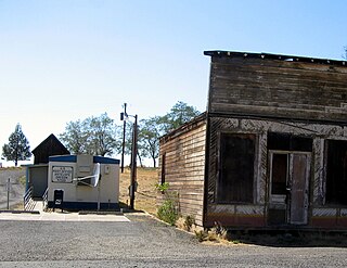
Antelope is a city in rural Wasco County, Oregon, United States. Antelope had an estimated population of 47 people in 2012.

Maupin is a city in Wasco County, Oregon, United States. Located on the Deschutes River, much of the city's economy is related to the river through outdoor activities, such as fishing and rafting. The population was 418 at the 2010 census.

The Deschutes River in central Oregon is a major tributary of the Columbia River. The river provides much of the drainage on the eastern side of the Cascade Range in Oregon, gathering many of the tributaries that descend from the drier, eastern flank of the mountains. The Deschutes provided an important route to and from the Columbia for Native Americans for thousands of years, and then in the 19th century for pioneers on the Oregon Trail. The river flows mostly through rugged and arid country, and its valley provides a cultural heart for central Oregon. Today the river supplies water for irrigation and is popular in the summer for whitewater rafting and fishing.
The Little Deschutes River is a tributary of the Deschutes River in the central part of the U.S. state of Oregon. It is about 105 miles (169 km) long, with a drainage basin of 1,020 square miles (2,600 km2). It drains a rural area on the east side of the Cascade Range south of Bend. The Little Deschutes and two other streams in its basin are listed as parts of the National Wild and Scenic Rivers System.

Tumalo Creek is a tributary, about 20 miles (32 km) long, of the Deschutes River, located in Deschutes County in Central Oregon, United States. It rises in the Cascade Range at 44.04706°N 121.598647°W, where Middle Fork Tumalo Creek and North Fork Tumalo Creek meet, and forms several waterfalls, including the 97-foot (30 m) Tumalo Falls. Its mouth is on the Deschutes at 44.1159506°N 121.3394783°W.
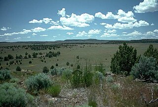
The Oregon High Desert is a region of the U.S. state of Oregon located east of the Cascade Range and south of the Blue Mountains, in the central and eastern parts of the state. Divided into a southern region and a northern region, the desert covers most of five Oregon counties and averages 4,000 feet (1,200 m) above sea level. The southwest region is part of the Great Basin and the southeast is the lower Owyhee River watershed. The northern region is part of the Columbia Plateau, where higher levels of rainfall allow the largest industry on private land to be the cultivation of alfalfa and hay. Public land within the region is owned primarily by the Bureau of Land Management, which manages more than 30,000 square miles (78,000 km2) including five rivers designated as Wild and Scenic.

Homestead is an unincorporated community in Baker County, in the U.S. state of Oregon. Homestead lies on the Snake River south of Hells Canyon National Recreation Area and about 4 miles (6 km) north of Copperfield and Oxbow.

Cline Falls State Scenic Viewpoint is a state park near Redmond, Oregon, United States. It is located on the Deschutes River. The park covers 9 acres (36,000 m2). It is administered by the Oregon Parks and Recreation Department.
The Boxcar Rapids are Class 3 rapids on the Deschutes River, located south and upriver from Maupin, Oregon, United States.
Robinette is a former unincorporated community in Baker County, Oregon, United States.
Howard Maupin (1815–1887) was an American settler who established a farm and ferry in Oregon at the present-day location of Maupin. He became famous for shooting the Paiute war leader Chief Paulina on April 25, 1867, near the modern town of Madras.
The Dry River is an intermittent tributary, 88 miles (142 km) long, of the Crooked River in the U.S. state of Oregon. The stream arises near Hampton Buttes north of Hampton and U.S. Route 20 between Brothers and Riley in the Oregon High Desert. Beginning in eastern Deschutes County near its border with Crook County, it flows generally northwest along the Deschutes–Crook county line, crossing briefly into Crook County before turning slightly south and returning to Deschutes County. Along these upper reaches, it flows roughly parallel to the highway, under which it passes several times before turning sharply north near the Horse Ridge Research Natural Area, 19 miles (31 km) southeast of Bend. Continuing north and re-entering Crook County, it passes under Powell Butte Highway, Oregon Route 126, and Oregon Route 370 before entering the Crooked River 34 miles (55 km) from the larger stream's confluence with the Deschutes River.

Whychus Creek is a tributary of the Deschutes River in Deschutes and Jefferson counties in the U.S. state of Oregon. Formerly named Squaw Creek, considered derogatory in the 21st century, it was renamed in 2006. Explorer John C. Frémont camped along the stream in 1843 but did not identify it by name. Robert S. Williamson, a surveyor who camped there in 1855, said its Indian name was Why-chus.

Gateway is an unincorporated community in Jefferson County, Oregon, United States. It is located about 16 miles east of Warm Springs.
Bakeoven is an unincorporated community in Wasco County, in the U.S. state of Oregon. It is southeast of Maupin and northwest of Shaniko along Bakeoven Creek, a tributary of the Deschutes River.
Criterion is an historic unincorporated community in Wasco County, in the U.S. state of Oregon. It lies along U.S. Route 197 between Maupin and Madras. Nearby is Criterion Summit, which at about 3,360 feet (1,020 m) above sea level is the highest point along the highway between The Dalles to the north and Redmond to the south. In the late 19th century, the route over the summit was a wagon road linking The Dalles to Lakeview and California.
South Junction is an unincorporated community in Wasco County, in the U.S. state of Oregon. It lies at the west end of South Junction Road on the east bank of the Deschutes River across from the mouth of the Warm Springs River. The road connects South Junction with Shaniko Junction to the northeast, where U.S. Route 97 and U.S. Route 197 intersect.
Pringle Falls is a series of rapids or drops on the upper Deschutes River in the U.S. state of Oregon. From just downstream of Wyeth Campground, the rapids begin with about 600 feet (180 m) of whitewater rated class II (novice) on the International Scale of River Difficulty. The next 300 feet (91 m) is class III (intermediate] ending in a class IV drop. Soggy Sneakers: A Paddler's Guide to Oregon's Rivers says, "Only expert kayakers should consider this drop, and only after scouting. It is definitely not a rapids for open canoes."
Penn is an unincorporated community and former railway station in Lane County, in the U.S. state of Oregon. It was named for the Penn Timber Company, which operated in the vicinity.
Shevlin was an unincorporated community in Deschutes and Klamath counties in the U.S. state of Oregon. It consisted of a collection of logging camp buildings that were moved from place to place on rail cars as logging progressed. The loggers worked for the Shevlin–Hixon Company.


