Dufur, Oregon

Last updated

Dufur, Oregon
Balch Hotel - Dufur Oregon.jpg
The Balch Hotel in Dufur
Wasco County Oregon Incorporated and Unincorporated areas Dufur Highlighted.svg
Location in Oregon
Coordinates: 45°27′11″N121°07′38″W / 45.45306°N 121.12722°W / 45.45306; -121.12722
Country United States
State Oregon
County Wasco
Incorporated 1893
Government
   Mayor Merle Keys [1]
Area
[2]
  Total0.59 sq mi (1.53 km2)
  Land0.59 sq mi (1.53 km2)
  Water0.00 sq mi (0.00 km2)
Elevation
[3]
1,339 ft (408 m)
Population
 (2020) [4]
  Total632
  Density1,073.01/sq mi (414.29/km2)
Time zone UTC-8 (Pacific)
  Summer (DST) UTC-7 (Pacific)
ZIP code
97021
Area code(s) 458 and 541
FIPS code 41-20900 [5]
GNIS feature ID2410366 [3]
Website cityofdufur.org

Dufur is a city in Wasco County, Oregon, United States. The population was 604 at the 2010 census. It is a farming community where wheat, tree fruit, and grapes are important crops.

Contents

History

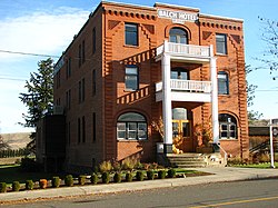
Dufur was incorporated on February 10, 1893, [6] and named after Andrew Dufur and his brother Enoch Burnham Dufur. In 1859 they began raising stock on 600 acres (2.4 km2) of land located where the city now stands.

In 2018, areas of Dufur were evacuated due to three wildfires, the Long Hollow Fire, the Substation Fire, and the South Valley Fire, which burned over 100,000 acres in total.

Geography

According to the United States Census Bureau, the city has a total area of 0.58 square miles (1.50 km2), all of it land. [7]

The hillside letter D can be seen in the northwest. ( 45°27′29″N121°08′19″W / 45.458°N 121.1387°W / 45.458; -121.1387 (Dufur D) )

Climate

This region experiences warm (but not hot) and dry summers, with no average monthly temperatures above 68 °F. According to the Köppen Climate Classification system, Dufur has a warm-summer Mediterranean climate, abbreviated "Csb" on climate maps. [8]

Aerial view of the city Dufur, Oregon - panoramio.jpg
Aerial view of the city
Climate data for Dufur
MonthJanFebMarAprMayJunJulAugSepOctNovDecYear
Record high °F (°C)70
(21)
73
(23)
80
(27)
90
(32)
103
(39)
106
(41)
110
(43)
109
(43)
103
(39)
92
(33)
75
(24)
67
(19)
110
(43)
Average high °F (°C)39.5
(4.2)
46
(8)
54.4
(12.4)
62.1
(16.7)
70.4
(21.3)
77.3
(25.2)
85.9
(29.9)
85
(29)
77
(25)
63.9
(17.7)
48.6
(9.2)
40.5
(4.7)
62.5
(16.9)
Average low °F (°C)23.8
(−4.6)
27.1
(−2.7)
30.9
(−0.6)
34.3
(1.3)
39.6
(4.2)
44.8
(7.1)
48.8
(9.3)
48.4
(9.1)
43.4
(6.3)
36.4
(2.4)
30.2
(−1.0)
25.8
(−3.4)
36.1
(2.3)
Record low °F (°C)−26
(−32)
−28
(−33)
5
(−15)
16
(−9)
10
(−12)
23
(−5)
31
(−1)
32
(0)
17
(−8)
8
(−13)
−12
(−24)
−25
(−32)
−28
(−33)
Average precipitation inches (mm)2.01
(51)
1.4
(36)
1.09
(28)
0.81
(21)
0.86
(22)
0.68
(17)
0.24
(6.1)
0.29
(7.4)
0.59
(15)
0.91
(23)
1.82
(46)
2.08
(53)
12.77
(324)
Average snowfall inches (cm)9.7
(25)
4.9
(12)
1.5
(3.8)
0.1
(0.25)
0
(0)
0
(0)
0
(0)
0
(0)
0
(0)
0.2
(0.51)
2.8
(7.1)
7.6
(19)
26.7
(68)
Average precipitation days121097652247111287
Source: [9]

Demographics

Historical population
CensusPop.Note
1900 336
1910 52355.7%
1920 5331.9%
1930 382−28.3%
1940 3922.6%
1950 4227.7%
1960 48815.6%
1970 4931.0%
1980 56013.6%
1990 527−5.9%
2000 58811.6%
2010 6042.7%
2020 6324.6%
U.S. Decennial Census [10] [4]
Namesake, Enoch Dufur Enoch B. Dufur 1910.JPG
Namesake, Enoch Dufur

2010 census

As of the census [11] of 2010, there were 604 people, 244 households, and 163 families living in the city. The population density was 1,041.4 inhabitants per square mile (402.1/km2). There were 263 housing units at an average density of 453.4 per square mile (175.1/km2). The racial makeup of the city was 94.5% White, 1.7% Native American, 0.2% Asian, 0.2% Pacific Islander, 1.3% from other races, and 2.2% from two or more races. Hispanic or Latino of any race were 1.5% of the population.

There were 244 households, of which 33.2% had children under the age of 18 living with them, 55.7% were married couples living together, 7.8% had a female householder with no husband present, 3.3% had a male householder with no wife present, and 33.2% were non-families. 29.5% of all households were made up of individuals, and 14% had someone living alone who was 65 years of age or older. The average household size was 2.47 and the average family size was 3.04.

The median age in the city was 42.6 years. 26.2% of residents were under the age of 18; 5.9% were between the ages of 18 and 24; 20.2% were from 25 to 44; 27.1% were from 45 to 64; and 20.5% were 65 years of age or older. The gender makeup of the city was 50.2% male and 49.8% female.

2000 census

As of the census [5] of 2000, there were 588 people, 244 households, and 173 families living in the city. The population density was 1,007.5 inhabitants per square mile (389.0/km2). There were 265 housing units at an average density of 454.1 per square mile (175.3/km2). The racial makeup of the city was 97.45% White, 0.68% Native American, 0.34% from other races, and 1.53% from two or more races. Hispanic or Latino of any race were 1.36% of the population.

There were 244 households, out of which 32.0% had children under the age of 18 living with them, 57.8% were married couples living together, 8.2% had a female householder with no husband present, and 28.7% were non-families. 26.2% of all households were made up of individuals, and 11.9% had someone living alone who was 65 years of age or older. The average household size was 2.41 and the average family size was 2.89.

In the city, the population was spread out, with 26.5% under the age of 18, 4.4% from 18 to 24, 21.9% from 25 to 44, 28.4% from 45 to 64, and 18.7% who were 65 years of age or older. The median age was 43 years. For every 100 females, there were 103.5 males. For every 100 females age 18 and over, there were 102.8 males.

The median income for a household in the city was $37,500, and the median income for a family was $41,667. Males had a median income of $34,375 versus $19,792 for females. The per capita income for the city was $17,615. About 5.2% of families and 8.3% of the population were below the poverty line, including 10.4% of those under age 18 and 7.5% of those age 65 or over.

Culture

On the second full weekend of August, Dufur holds its annual Threshing Bee, a harvest festival celebrating the local agricultural economy. The festival includes demonstrations of horse-drawn harvesting equipment, and a steam tractor that powers a belt-driven threshing machine.

Notable people

See also

Related Research Articles

<span class="mw-page-title-main">Goodwater, Alabama</span> Town in Alabama, United States

Goodwater is a town in Coosa County, Alabama, United States. At the 2020 census, the population was 1,291. It is part of the Talladega-Sylacauga Micropolitan Statistical Area.

<span class="mw-page-title-main">Alton, Missouri</span> City in Missouri, United States

Alton is a city and the county seat of Oregon County, Missouri, United States. The population was 707 at the 2020 census.

<span class="mw-page-title-main">Lincoln, North Dakota</span> City in North Dakota, United States

Lincoln is a city in Burleigh County, North Dakota, United States. It is a suburb of adjacent Bismarck, and also a core city of the Bismarck-Mandan Metropolitan Statistical Area. The population was 4,257 at the 2020 census, making it the 14th most populous city in North Dakota. Lincoln was founded in 1977.

<span class="mw-page-title-main">Park River, North Dakota</span> City in North Dakota, United States

Park River is a city in Walsh County, North Dakota, United States. The population was 1,424 at the 2020 census. Park River was founded in 1884.

<span class="mw-page-title-main">Kenmare, North Dakota</span> City in North Dakota, United States

Kenmare is a city in Ward County, North Dakota, United States. The population was 961 at the 2020 census. Kenmare is part of the Minot Micropolitan Statistical Area.

<span class="mw-page-title-main">Haines, Oregon</span> City in Oregon, United States

Haines is a city in Baker County, Oregon, United States. The population was 416 at the 2010 census.

<span class="mw-page-title-main">Richland, Oregon</span> City in Oregon, United States

Richland is a city in Baker County, Oregon, United States. The population was 156 at the 2010 census.

<span class="mw-page-title-main">Unity, Oregon</span> City in Oregon, United States

Unity is a city in Baker County, Oregon, United States, located in the Burnt River Valley. The population was 71 at the 2010 census.

<span class="mw-page-title-main">Butte Falls, Oregon</span> City in Oregon, United States

Butte Falls is a city in Jackson County, Oregon, United States. The population was 423 at the 2010 census. As of July 1, 2018, the city's population was estimated to be 450.

<span class="mw-page-title-main">Lowell, Oregon</span> City in Oregon, United States

Lowell is a city in Lane County, in the U.S. state of Oregon. As of the 2010 census, the city population was 1,045. The city is on the north shore of Dexter Reservoir on the Middle Fork Willamette River. The most used route to Lowell is along Lowell Bridge, a covered bridge that crosses the reservoir from Oregon Route 58.

<span class="mw-page-title-main">Sodaville, Oregon</span> City in Oregon, United States

Sodaville is a city in Linn County, Oregon, United States. The population was 308 at the 2010 census.

<span class="mw-page-title-main">Adrian, Oregon</span> City in Oregon, United States

Adrian is a city in Malheur County, Oregon, United States, near the confluence of the Snake River and the Owyhee River. The population was 177 at the 2010 census. It is part of the Ontario, OR–ID Micropolitan Statistical Area.

<span class="mw-page-title-main">Ione, Oregon</span> City in Oregon, United States

Ione is a city in Morrow County, Oregon, United States. The population was 329 at the 2010 census. It is part of the Pendleton–Hermiston Micropolitan Statistical Area.

<span class="mw-page-title-main">Irrigon, Oregon</span> City in Morrow County, Oregon, United States

Irrigon is a city in Morrow County, Oregon, United States, on the Columbia River and U.S. Route 730. The city is part of the Pendleton–Hermiston Micropolitan Statistical Area. The population was 1,826 at the 2010 census.

<span class="mw-page-title-main">Falls City, Oregon</span> City in Oregon, United States

Falls City is a city in Polk County, Oregon, United States. The population was 1,051 at the 2020 census. It is part of the Salem Metropolitan Statistical Area.

<span class="mw-page-title-main">Rufus, Oregon</span> City in Oregon, United States

Rufus is a city in Sherman County, Oregon, United States. The population was 249 at the 2010 census. The city was named for an early settler, Rufus Carrol Wallis.

<span class="mw-page-title-main">Wasco, Oregon</span> City in Oregon, United States

Wasco is a city in Sherman County, Oregon, United States. The population was 410 at the 2010 census.

<span class="mw-page-title-main">Bay City, Oregon</span> City in Oregon, United States

Bay City is a city in Tillamook County, Oregon, United States. The population was 1,286 at the 2010 census.

<span class="mw-page-title-main">Ukiah, Oregon</span> City in Oregon, United States

Ukiah (/juːkaɪʌ/) is a city in Umatilla County, Oregon, United States. The population was 186 at the 2010 census. It is part of the Hermiston-Pendleton Micropolitan Statistical Area. It was named by an early settler after the town of Ukiah, California.

<span class="mw-page-title-main">Idanha, Oregon</span> City in Oregon, United States

Idanha is a city on the Marion County/Linn County line in Oregon, United States, on Oregon Route 22 and the Santiam River. The population was 156 at the 2020 census.

References

  1. "City Council". City of Dufur. March 23, 2021. Archived from the original on May 6, 2021.
  2. "ArcGIS REST Services Directory". United States Census Bureau. Retrieved October 12, 2022.
  3. 1 2 U.S. Geological Survey Geographic Names Information System: Dufur, Oregon
  4. 1 2 "Census Population API". United States Census Bureau. Retrieved October 12, 2022.
  5. 1 2 "U.S. Census website". United States Census Bureau . Retrieved January 31, 2008.
  6. Leeds, W. H. (1899). "Special Laws". The State of Oregon General and Special Laws and Joint Resolutions and Memorials Enacted and Adopted by the Twentieth Regular Session of the Legislative Assembly. Salem, Oregon: State Printer: 1055.
  7. "US Gazetteer files 2010". United States Census Bureau. Archived from the original on July 2, 2012. Retrieved December 21, 2012.
  8. Climate Summary for Dufur, Oregon
  9. "DUFUR, OR (352440)". Western Regional Climate Center. Retrieved November 23, 2015.
  10. "Census of Population and Housing". Census.gov. Retrieved June 4, 2015.
  11. "U.S. Census website". United States Census Bureau . Retrieved December 21, 2012.