
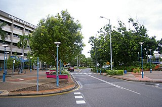
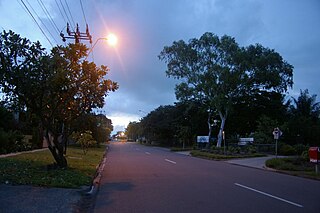
Darwin is the capital city of the Northern Territory, Australia. The city has nearly 53% of the Northern Territory's population, with 139,902 at the 2021 census. It is the smallest, wettest, and most northerly of the Australian capital cities and serves as the Top End's regional centre.

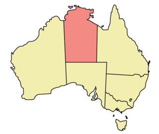
The Northern Territory is an Australian internal territory in the central and central northern regions of Australia. The Northern Territory shares its borders with Western Australia to the west, South Australia to the south, and Queensland to the east. To the north, the territory looks out to the Timor Sea, the Arafura Sea and the Gulf of Carpentaria, including Western New Guinea and other islands of the Indonesian archipelago.
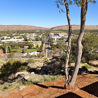
Alice Springs is a town in the Northern Territory, Australia; the third largest settlement after Darwin and Palmerston. The name Alice Springs was given by surveyor William Whitfield Mills after Alice, Lady Todd, wife of the telegraph pioneer Sir Charles Todd. Known colloquially as The Alice or simply Alice, the town is situated roughly in Australia's geographic centre. It is nearly equidistant from Adelaide and Darwin.
Palmerston is a planned satellite city of Darwin, the capital and largest city of Australia's Northern Territory. The city is situated approximately 20 kilometres from Darwin and 10 kilometres from Howard Springs and the surrounding rural areas. Palmerston had a population of 33,695 at the 2016 census, making it the second largest city in the Northern Territory.
Local government is the third-level of government in Australia, administered with limited autonomy under the states and territories, and in turn beneath the federal government. Local government is not mentioned in the Constitution of Australia, and two referendums in 1974 and 1988 to alter the Constitution relating to local government were unsuccessful. Every state/territory government recognises local government in its own respective constitution. Unlike the two-tier local government system in Canada or the United States, there is only one tier of local government in each Australian state/territory, with no distinction between counties and cities.
Tennant Creek is a town located in the Northern Territory of Australia. It is the seventh largest town in the Northern Territory, and is located on the Stuart Highway, just south of the intersection with the western terminus of the Barkly Highway. At the 2021 census, Tennant Creek had a population of 3,080 people, of which 55% (1,707) identified themselves as Indigenous.

Adelaide River is a small but historically significant town located at the crossing of the Stuart Highway over the Adelaide River in the Northern Territory of Australia. The town is upstream of the Adelaide and Mary River Floodplains Important Bird Area. At the 2021 census, Adelaide River had a population of 317. Adelaide River is part of the Coomalie Shire and is the second largest settlement in the local government area.

Kalkarindji is a town and locality in the Northern Territory of Australia, located on the Buntine Highway about 554 kilometres (344 mi) south of the territory capital of Darwin and located about 460 kilometres (290 mi) south of the municipal seat in Katherine.
Crime in the Northern Territory is managed by the Northern Territory Police, the territory government's Department of the Attorney-General and Justice and Territory Families.
Larrakeyah is an inner suburb of Darwin, the capital city of Australia's Northern Territory. It is the traditional country and waterways of the Larrakia people. It was one of the first parts of the city to be developed, and borders the Darwin Central Business District.

Batchelor is a town in the Northern Territory of Australia. The town is the current seat and largest town of the Coomalie Shire local government area. It is located 98 kilometres (61 mi) south of the territory capital, Darwin. A number of residents commute to Darwin and its suburbs for work.
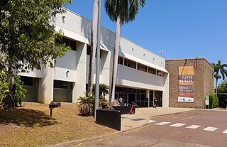
The Museum and Art Gallery of the Northern Territory (MAGNT) is the main museum in the Northern Territory. The headquarters of the museum is located in the inner Darwin suburb of The Gardens. The MAGNT is governed by the Board of the Museum and Art Gallery of the Northern Territory and is supported by the Museums and Art Galleries of the Northern Territory Foundation. Each year the MAGNT presents both internally developed exhibitions and travelling exhibitions from around Australia. It is also the home of the annual Telstra National Aboriginal and Torres Strait Islander Art Award, Australia's longest-running set of awards for Indigenous Australian artists.

Holtze is a locality in Darwin, Northern Territory, Australia. It is 22 km southeast of the Darwin CBD. Its local government area is the Municipality of Litchfield. The locality is mostly a rural area, just north of Palmerston. It was named for Maurice William Holtze (1840–1923), the botanist who established Darwin's Botanical Gardens, and his son Nicholas, who succeeded him as curator.

Darwin City is a suburb in metropolitan Darwin which comprises the original settlement, the central business district, parkland and other built-up areas. It is the traditional country and waterways of the Larrakia people. It is original site of occupation and includes many of the city's important institutions and landmarks, such as Parliament, Government House, the Northern Territory Supreme Court, Bicentennial Park and the George Brown Darwin Botanic Gardens. The city centre is located in the local government areas of the City of Darwin and the Darwin Waterfront Precinct.
Daguragu, previously also known as Wattie Creek by the Gurindji people as it is situated on a tributary of the Victoria River, is a locality in the Northern Territory of Australia. It is located about 551 kilometres (342 mi) south of the territory capital of Darwin and located about 460 kilometres (290 mi) south-west of the municipal seat in Katherine. It is around 8 km (5.0 mi) north-west of Kalkarindji. Daguragu community is situated on Aboriginal land held under perpetual title; it was also formerly a local government area until its amalgamation into the Victoria Daly Shire on 1 July 2008.
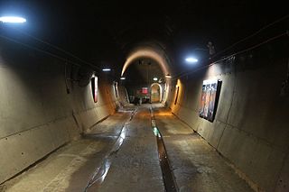
The Darwin oil storage tunnels were built during World War II to protect the oil stored in the Australian city of Darwin from Japanese bombing. They are below the cliffs of Darwin City in the Darwin Wharf Precinct on Kitchener Drive, a part of the Waterfront Precinct. By the time the tunnels were completed the risk from bombing had gone and the tunnels never stored oil.

Stokes Hill Wharf is the main wharf for the city of Darwin in the Northern Territory of Australia and is named after Stokes Hill, adjacent. The hill itself was named in 1839 by the commander of HMS Beagle, after its previous commander, Captain Pringle Stokes.
East Arm is a suburb in the Northern Territory of Australia located in Darwin about 8 kilometres (5.0 mi) east of Darwin City overlooking a part of Darwin Harbour known as the East Arm. It is the traditional land and waterways of the Larrakia people.
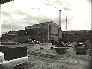
Stokes Hill Power Station was an oil-fired thermal power station in Darwin, Northern Territory, Australia. During its operating life, it was the largest power station in the Northern Territory, although it was considered unreliable and highly inefficient. Stokes Hill's high operating costs required government to heavily subsidise power bills for Darwin residents, who frequently experienced supply disruptions.
