Darwin is the capital city of the Northern Territory, Australia. With a population of 139,902 at the 2021 census, the city contains most of the sparsely populated Northern Territory's residents. It is the smallest, wettest, and most northerly of the Australian capital cities and serves as the Top End's regional centre.
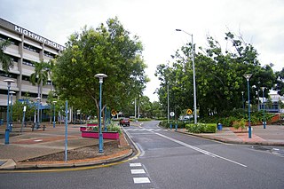
Palmerston is a planned satellite city of Darwin, the capital and largest city of Australia's Northern Territory. The city is situated approximately 20 kilometres from Darwin and 10 kilometres from Howard Springs and the surrounding rural areas. Palmerston had a population of 33,695 at the 2016 census, making it the second largest city in the Northern Territory.

The Litchfield Council is a local government area of the Northern Territory of Australia on the eastern and southeastern outskirts of the Darwin-Palmerston urban area. The municipality covers an area of 2,903 square kilometres (1,120.9 sq mi), and was created by the Northern Territory government on 6 September 1985.

The Belyuen Shire is a local government area in the Northern Territory of Australia near Wagait Beach on the Cox Peninsula located across Darwin Harbour from the city of Darwin. The administrative area is centred on the mostly Indigenous community of Belyuen, known officially as Delissaville prior to 1975. Delissaville and its airstrip were named for Benjamin Cohen De Lissa of Queensland, sugar grower and investor in G. T. Bean's failed Port Darwin Sugar Company and the equally unsuccessful Delissa Pioneer Sugar Company.

The City of Darwin is a local government area of the Northern Territory, Australia. It includes the central business district of the capital, Darwin City, and represents two-thirds of its metropolitan population. Located on the traditional land and waterways of the Larrakia people, the city now covers an area of 111 square kilometres (43 sq mi) and, in June 2018, had a population of 84,613 people.

The Coomalie Community Government Council is a local government area in Australia's Northern Territory, situated south of Darwin and Palmerston. The council governs an area of 2,056 km2 (794 sq mi). The shire had a population of 1,391 in June 2018.
The Victoria Daly Regional Council is a local government area in the Northern Territory of Australia. The shire covers an area of 153,287 square kilometres (59,184 sq mi) and had a population of 3,138 in June 2018.

The West Arnhem Region is a local government area of the Northern Territory, Australia and is administered by the West Arnhem Regional Council. The region covers an area of 49,675 square kilometres (19,180 sq mi) and had a population of 6,902 in June 2018.

The Tiwi Islands Region is a local government area (LGA) of the Northern Territory, Australia. The LGA covers an area of 7,483 square kilometres (2,889 sq mi) and had an estimated population of 2,753 in June 2018, and is governed by the Tiwi Islands Regional Council, formerly Tiwi Islands Shire Council.
The Central Desert Region is a local government area of the Northern Territory, Australia, administered by the Central Desert Regional Council. The council's main towns are Ti-Tree, Yuendumu, and Lajamanu. The Region covers an area of 281,312 square kilometres (108,615 sq mi) and had a population of 4,208 in June 2018.

The Gardens is an inner suburb of the city of Darwin, Northern Territory, Australia. It is the traditional country and waterways of the Larrakia people.

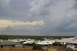
Archer is a relatively new and still sparsely populated suburb in the southwestern part of Palmerston. It is 25 km SE of the Darwin CBD and 5.4 km from Palmerston City. It is on the traditional Country and waterways of the Larrakia people. Its local government area is the City of Palmerston. Archer is the largest suburb of Palmerston by area.
Durack is an inner-city suburb of Palmerston. It is 22 km southeast of the Darwin CBD. Its local government area is the City of Palmerston. It is located on the traditional Country and waterways of the Larrakia people.
Marlow Lagoon is an outer western suburb of Palmerston 24 km SE of the Darwin CBD. Its local government area is the City of Palmerston. Marlow Lagoon is bounded to the west by the Adelaide-Darwin Railway, and to the east by Elrundie Ave. It is on the traditional Country and waterways of the Larrakia people.

Holtze is a locality in Darwin, Northern Territory, Australia. It is 22 km southeast of the Darwin CBD. Its local government area is the Municipality of Litchfield. The locality is mostly a rural area, just north of Palmerston. It was named for Maurice William Holtze (1840–1923), the botanist who established Darwin's Botanical Gardens, and his son Nicholas, who succeeded him as curator.
Mitchell is a suburb in the Northern Territory of Australia located in the city of Palmerston about 18 kilometres (11 mi) south-east of Darwin City.
The Katherine Town Council is a local government area in the Northern Territory, established on 3 March 1978. It is situated 320 kilometres (200 mi) south of Darwin, and covers an area of 7,417 square kilometres (2,864 sq mi).

Yarrawonga is an outer northern suburb of Palmerston. It is on the traditional Country and waterways of the Larrakia people.

Darwin City is a suburb in metropolitan Darwin which comprises the original settlement, the central business district, parkland and other built-up areas. It is the traditional country and waterways of the Larrakia people. It is original site of occupation and includes many of the city's important institutions and landmarks, such as Parliament, Government House, the Northern Territory Supreme Court, Bicentennial Park and the George Brown Darwin Botanic Gardens. The city centre is located in the local government areas of the City of Darwin and the Darwin Waterfront Precinct.

Pinelands is an outer northern suburb of Palmerston, Northern Territory, Australia. It is 21 km southeast of the Darwin CBD and 2.1 km from Palmerston City. Its local government area is the City of Palmerston. It is on the traditional Country and waterways of the Larrakia people.