
Hunter Army Airfield, located in Savannah, Georgia, United States, is a military airfield and subordinate installation to Fort Stewart located in Hinesville, Georgia.

Waco Regional Airport is five miles northwest of Waco, in McLennan County, Texas. It is owned by the City of Waco.

Florence Regional Airport is three miles east of Florence, in Florence County, South Carolina.

Salinas Municipal Airport, commonly referred to as Salinas Airport is an airport in Monterey County, California, United States, three miles (4.8 km) southeast of Downtown Salinas. It is included in the 2017–21 National Plan of Integrated Airport Systems as a regional general aviation airport. It had 1,800 enplanements in 2014.
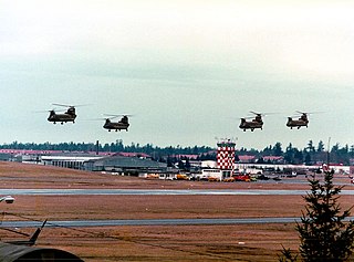
Gray Army Airfield, also known as Gray AAF, is a military airfield located within Joint Base Lewis–McChord near Tacoma, in Pierce County, Washington, United States.

Cairns Army Airfield is a military airport forming a part of Fort Novosel, in Dale County, Alabama, USA, and is owned by the United States Army. The airfield is south of the town of Daleville, which sits between it and the main post.
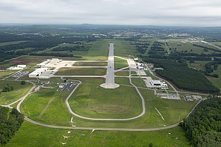
Redstone Army Airfield or Redstone AAF is a military airport located at Redstone Arsenal, six miles southwest of the city of Huntsville in Madison County, Alabama, United States. The airfield was originally constructed for munitions testing for the U.S. Army and the U.S. Army Air Forces through the 6th AAF Base Unit. It is currently used to support the U.S. Army Aviation and Missile Command, NASA, and other U.S. government aviation and space activities.
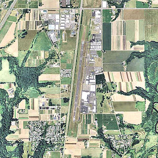
Wheeler-Sack Army Airfield is a military use airport located at Fort Drum, in Jefferson County, New York, United States. It is owned by the U.S. Army.
Aurora State Airport is a public airport located one mile (2 km) northwest of the central business district of Aurora, a city in Marion County, Oregon, United States. It is owned by the Oregon Department of Aviation.
MidCoast Regional Airport at Wright Army Airfield is a joint public and military use airport at Fort Stewart, a United States Army post located near the city of Hinesville in Liberty County, Georgia, United States. The airport's physical address is 1116 E. Lowe Circle, Fort Stewart, GA 31314 and its mailing address is P.O. Box 10, Hinesville, GA 31310.

Brooksville–Tampa Bay Regional Airport, formerly known as Hernando County Airport, is a joint civil-military public airport located 6 nautical miles (11 km) southwest of the central business district of Brooksville, a city in Hernando County, Florida, United States. It is owned by Hernando County and is 45 miles (72 km) north of Tampa. While having consistent growth in its traffic rate, it does not yet serve the public through commercial airlines, but it does have charter and executive service.
Flagler Executive Airport (ICAO: KFIN, FAA LID: FIN) is a county-owned public-use airport located three miles (5 km) east of the central business district of Bunnell, a city in Flagler County, Florida, United States. The airport's former FAA location identifiers were X47 and XFL. The airfield was originally constructed by the United States Navy during World War II as Naval Outlying Field Bunnell (NOLF Bunnell), an auxiliary airfield for flight training operations originating from nearby Naval Air Station Jacksonville, NAS Daytona Beach and NAS DeLand. Following the end of the war, the airfield was transferred from the Navy to Flagler County for use as a general aviation airport.

Gainesville Municipal Airport is three miles west of Gainesville, in Cooke County, Texas.

Troy Municipal Airport is a city-owned public-use airport located four nautical miles northwest of the central business district of Troy, a city in Pike County, Alabama, United States. It is included in the FAA's National Plan of Integrated Airport Systems for 2011–2015, which categorized it as a general aviation facility.

Crisp County–Cordele Airport is a county-owned, public-use airport located two nautical miles (4 km) northeast of the central business district of Cordele, a city in Crisp County, Georgia, United States. It is included in the National Plan of Integrated Airport Systems for 2011–2015, which categorized it as a general aviation facility. The airport does not have scheduled commercial airline service.
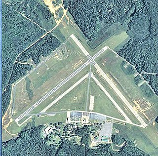
Campbell Army Airfield is a military airport at Fort Campbell, which is located near Hopkinsville, a city in Christian County, Kentucky, United States.

Mainz-Finthen Airfield(German: Flugplatz Mainz-Finthen) is a recreational aerodrome in Germany, located about 3 miles (5 km) southwest of Mainz and approximately 320 miles (510 km) southwest of Berlin.

Simmons Army Airfield is a military use airport located in Cumberland County, North Carolina, United States. It is located on the southeast portion of Fort Liberty and supports the aviation needs of the XVIII Airborne Corps, the 82nd Airborne Division, Special Operations, U.S. Army Reserve and U.S. National Guard aviation units.

The Muir Army Airfield (IATA: MUI, ICAO: KMUI, FAA LID: MUI) is a military airport at Fort Indiantown Gap, near Annville, Pennsylvania, United States. It is home to the 28th Combat Aviation Brigade and Eastern Army National Guard Aviation Training Site (EAATS), operated by the Pennsylvania Army National Guard. It is 24 nautical miles (44 kilometres) northeast of the central business district of Harrisburg, in South Central Pennsylvania. The airfield has one active runway designated 7/25 with a 3,978 ft × 98 ft (1,212 m × 30 m) asphalt surface.

Robinson Army Airfield is a military airfield at the Robinson Maneuver Training Center in Pulaski County, Arkansas, United States. The airfield is located five nautical miles northwest of the central business district of Little Rock, Arkansas. It is located within the Robinson Maneuver Training Center in North Little Rock, which is home to the Arkansas National Guard.


