
Palmdale Regional Airport is an airport in Palmdale, California, United States. The city of Palmdale took over the airport at the end of 2013, managing it via the Palmdale Airport Authority.
Falmouth Airpark is a public-use airport and residential airpark located four miles (6 km) northeast of the central business district of Falmouth, in Barnstable County, Massachusetts, United States. It is privately owned by Falmouth Airpark Homeowners Association. The airport grew to superscede the Coonamessett Airport which was located in close proximity to the Otis Air National Guard Base and closed in the 1960s.

Syracuse Suburban Airport is a former privately owned public-use airport in Oswego County, New York, United States. It is located 13 nautical miles (24 km) north of the central business district of the city of Syracuse. The airport is off Gildner Road in the village of Central Square, which is located in the Town of Hastings. The airport redevelopment was not completed and one of the owners pleaded guilty to bank fraud in July 2014.

Point Roberts Airpark is a single-grass-runway airport located in the town of Point Roberts, Washington. The airport, along with the marina, provide the only access to the rest of Washington state without first having to pass through British Columbia.
Air Park-Dallas Airport is a public airport located 16 nautical miles (30 km) northwest of the central business district of Dallas, in Collin County, Texas, United States. The airport is used solely for general aviation purposes. It was built as an airpark-style development, with adjacent homeowners having perpetual runway access guaranteed by restrictive covenants, but no formal ownership or management interest in the physical airfield facilities. The airport was formerly within the city limits of Hebron, Texas but was annexed by the city of Carrollton in 2008; the nearby residential lots were not included in the annexation.
Jumbolair Airport is a private-use airport. It is located in the unincorporated community of Anthony, which is seven miles (11 km) northeast of Ocala, Florida, United States. Frank Merschman owns and operates Jumbolair. The airport has two runways: 18/36 with an asphalt pavement measuring 7,550 x 210 ft and 9/27 with a grass surface measuring 3,640 x 100 ft. According to FAA documents, 9/27 ""Greystone"" grass airstrip was once so degraded that only the smallest aircraft could use it.

Newman's Airport is a privately owned, public airport located 7 mi west of Kalamazoo, Michigan, United States. It is a choice for many pilots in the area who wish to avoid the Kalamazoo-Battle Creek International Airport. Newman's is an airpark community consisting of 13 homes each with private hangars. The airport offers tie-downs and hangars.
Sandy Creek Airpark is a private residential airpark located in the East Bay Sector, 10 miles southeast of the central business district of Panama City, in Bay County, Florida, United States. This airport has one dusk-to-dawn lighted runway, and a green-white beacon. The facility is used primarily by residents/association members, their tenants and guests, and members of the EAA Chapter 202.
WWLV is a radio station licensed to Lexington, North Carolina, and serving the Piedmont Triad metropolitan area. The station is an affiliate of K-LOVE.
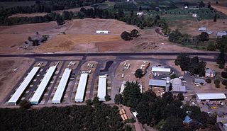
Stark's Twin Oaks Airpark is a privately owned public-use airport located 4 miles (6.4 km) south of the city of Hillsboro in Washington County, Oregon, United States.

Agua Dulce Airpark, also known as Agua Dulce Airport, is a public-use airport located 2 miles (3.2 km) east of the central business district of Agua Dulce, in Los Angeles County, California, United States.

Apple Valley Airport is a private airport located one mile southeast of Buxton in Washington County, Oregon, United States. Built in 1994 by a Portland TV personality Rod Anders, the subsequent owners have pushed to expand operations at the airport. Near U.S. 26 west of the Portland metropolitan area, the 2,470 feet (750 m) long turf airstrip is used for agricultural operations.

Sunset Air Strip is a private airport located one mile southwest of North Plains in Washington County, Oregon, USA. There are 16 aircraft based at the strip, which is managed by Roth Development Corp., which is owned by the neighbors. Some of the 17 neighbors to the strip have hangars on their property. The strip is owned by Roth Development, and the number of aircraft is limited to 50 by the Oregon Department of Aviation.

Ridge Landing Airpark, also known as Ridge Landing Airport, is a private use airpark located four nautical miles west of the central business district of Frostproof, Florida, United States. Ridge Landing is an airpark community located between Lake Wales and Sebring. Ridge Landing is centrally located between Orlando and Tampa and equidistant to Miami and Jacksonville. It is privately owned by John Fazzini.
Lakeway Airpark is a public use airport in Travis County, Texas, United States. The airport is 17 nautical miles west of the central business district of Austin. It is privately owned by Lakeway Airpark, Inc. and is located in Lakeway, Texas.
Haysfield Airport - MD24 was an airport located in Howard County, Maryland

Congressional Airport was a 40-acre (16 ha) airfield, located in what is now Rockville, Maryland, just outside Washington, D.C., used for the Civilian Pilot Training Program.
Eddie Dew Memorial Airpark, is a privately owned airport near Toronto, Ohio, U.S., part of the Pittsburgh Combined Statistical Area. The airport opened in December 1937. Twenty-two aircraft are reported as being based at the airport; approximately 2,850 aircraft movements per year take place.
Apex Airport is a private airstrip almost exactly two miles due west of Kitsap Mall in Silverdale, Washington, at elevation 525 feet (160 m). The runway, originally a bulldozed gravel strip, was built in 1946.
