The suburb of Dawes Point is on Gadigal Country. The point was originally known by the Aboriginal names of Tar-ra and Tullagalla. This was later changed by Governor Hunter at William Dawes' request to Point Maskelyne in honour of his patron Reverend Dr Nevil Maskelyne, British Astronomer Royal.[3] He sent out the first astronomical instruments which were established at the point in the country's first observatory, by Lieutenant William Dawes (1762–1836), astronomer with the First Fleet. The point was renamed in honour of Dawes.[4] Dawes Point is one of the places around Sydney Harbour that has been officially gazetted as a dual named site by the NSW Geographical Names Board. It was officially gazetted Dawes Point / Tar-Ra in 2002.[5]
It was also the site of the first guns mounted in Sydney by Dawes in 1788, contained Sydney's first cemetery and later Dawes Point Battery. Walsh Bay was the site of Sydney's port facilities. The wharves were converted to apartments, theatres, restaurants, cafes and a hotel.
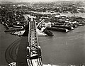
A section of Dawes Point that juts out onto the eastern side of the Harboour Bridge. The Rocks and Sydney Cove can also be seen. Photo has been taken from the Sydney Harbour Bridge shortly after its opening in March 1932
By the 1840s, the people of Dawes Point and Millers Point were a maritime community in which rich and poor mixed more than elsewhere in Sydney. Wharf owners and traders lived and worked beside those who worked on the wharves and bond stores, as well as those who arrived and left on ships.[6] Only two of the merchant houses, built by and for the early wharf owners, survive. One is Walker's 50-foot wide villa built around 1825 and now part of Milton Terrace at 7-9 Lower Fort Street; the other is the home and offices of Edwards and Hunter, built in 1833 above their wharves which is where the Wharf Theatre now stands.[7]
Mostly prosperous in its early years, the area was less desirable by the 1890s. At the beginning of the 20th century, the government compulsorily acquired all private wharves, homes and commercial properties in the Rocks, Dawes Point and Millers Point. Modern and efficient wharves with dual level access were built, as well as new accommodation for workers, such as the Workers Flats of Lower Fort Street designed by Government Architect Vernon.[8] During 2014–18, the majority of the area's social housing was sold and its tenants left the Millers Point area.
Heritage listings
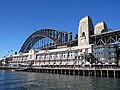
A view of Sydney Harbour from the end of Pier One. Dawes Point, 2025
81 Lower Fort Street, The Hero of Waterloo Hotel[12]
Population
At the 2021 census, the population of Dawes Point had increased to 385. 56.9% of people were born in Australia and 76.4% of people only spoke English at home. The most common response for religion was No Religion at 45.7%.[13] Median mortgage payments were $3,467 a month.[13]
In the 2016 census, there were 357 people in Dawes Point. 63.8% of people were born in Australia and 76.2% of people only spoke English at home. The most common response for religion was No Religion at 39.9%.[14]
Median mortgage repayments were $5,200 a month or $62,400 a year, the highest median mortgage repayment in the greater Sydney area.[14][15]
Culture
Walsh bay arts precinct, Dawes point, Sydney. 2025
The Wharf Theatres, which are part of the Sydney Theatre Company, are located in Pier 4/5, which is an early 20th-century renovated cargo wharf house that was completed between 1920 and 1921.[16] It is located in the Walsh Bay Wharves Precinct at Dawes Point. There are two theatres that make up the wharf theatres: Wharf theatre 1, which has 339 seats, and Wharf theatre 2, which has 205 seats. There are also five dance studios located in Pier 4/5 that are run by the Sydney Dance Company.[17] These dance studios are used by the Sydney Dance Company to create, rehearse, teach and perform dance in.[17]
The Sydney Theatre is also located at Dawes point opposite Pier 6/7. It is a former cargo storage site from the 1830s and is used by the Sydney Theatre Company, the Sydney Dance Company and the Sydney Writers' Festival.[18]
Gallery
Southern approach of the Sydney Harbour Bridge with Dawes Point to the right. 2008
Aerial view of Dawes point in the 1930s. The 9 Wharves which can be seen on the left date from between 1906 and 1922.
"Re-Emergence" by Sonia Payes in front of pier 6/7. Dawes Point, 2025
An art installation by Jimmie Durham titled "Still Life with Stone & Car". Created in 2003 and originally located near the Sydney Opera House, in 2006 it was moved to a roundabout in front of Pier 2/3 in Dawes point.[19]
↑Mander-Jones, Phyllis (1966). "Dawes, William (1762–1836)". Australian Dictionary of Biography. Archived from the original on 22 October 2012. Retrieved 10 July 2021.
↑The Book of Sydney Suburbs, Compiled by Frances Pollon, Angus & Robertson Publishers, 1990, Published in Australia ISBN0-207-14495-8, page 81
↑"Tar-Ra place name". NSW Geographical Names Board. Archived from the original on 10 July 2021. Retrieved 10 July 2021.
↑"1840". MILLERS POINT. Archived from the original on 28 February 2016. Retrieved 2 January 2016.
This page is based on this Wikipedia article Text is available under the CC BY-SA 4.0 license; additional terms may apply. Images, videos and audio are available under their respective licenses.