Deming Municipal Airport

Last updated
Deming Municipal Airport
Deming Army Airfield
Deming Municipal Airport - New Mexico.jpg
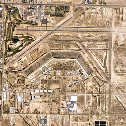
2006 USGS orthophoto
Summary
Airport typePublic
OwnerCity of Deming
Serves Deming, New Mexico
Elevation  AMSL 4,314 ft / 1,315 m
Coordinates 32°15′44″N107°43′14″W / 32.26222°N 107.72056°W / 32.26222; -107.72056 Coordinates: 32°15′44″N107°43′14″W / 32.26222°N 107.72056°W / 32.26222; -107.72056
Map
USA New Mexico location map.svg
Airplane silhouette.svg
DMN
Runways
Direction LengthSurface
ftm
8/266,6272,020Asphalt
4/225,6751,730Asphalt
Statistics (2008)
Aircraft operations28,655
Based aircraft17
Deming Army Airfield 1943 classbook Deming Army Airfield - 43-07 Classbook.pdf
Deming Army Airfield 1943 classbook

Deming Municipal Airport( IATA : DMN, ICAO : KDMN, FAA LID : DMN) is two miles southeast of Deming, in Luna County, New Mexico, United States. [1]

Contents

Facilities

The airport covers 2,870 acres (1,160 ha) at an elevation of 4,314 feet (1,315 m). It has two asphalt runways: 8/26 is 6,627 by 75 feet (2,020 x 23 m) and 4/22 is 5,675 by 60 feet (1,730 x 18 m). [1]

In the year ending April 13, 2008 the airport had 28,655 aircraft operations, average 78 per day: 65% general aviation, 32% military and 3% air taxi. 17 aircraft were then based at this airport: 94% single-engine and 6% multi-engine. [1]

World War II

AAF Bombardier School patch, 1943 AAF Bombardier School Deming Field New Mexico-Patch.png
AAF Bombardier School patch, 1943

The airfield was activated on 15 November 1942. It conducted bombardier training for USAAF Gulf Coast Training Center (later Central Flying Command). The first class of bombardiers graduated on 6 March. In the next three years an estimated 12,000 cadets passed through the Deming school. The bombardier trainer used was the Beech AT-11 Kansan.

The airfield was assigned to Second Air Force 16th Bombardment Training Wing on 31 December 1944. It conducted B-29 Superfortress group bombardment training until the end of World War II, when the training program at Deming wound down and was inactivated 18 December 1945. The airfield was closed on 31 January 1946. It was eventually discharged to the War Assets Administration (WAA) and sold.

Past airline service

Frontier Airlines (1950-1986) DC-3s served Deming starting in 1950, flying El Paso to Phoenix via Las Cruces, Deming, and Lordsburg, NM as well as Clifton, Safford, and Tucson, Arizona. [2] The service ended in April, 1953.

See also

Related Research Articles

Augusta Regional Airport Public airport near Augusta, GA, US

Augusta Regional Airport is a city-owned public airport six miles (11 km) south of Augusta, in Richmond County, Georgia, United States.

Waco Regional Airport

Waco Regional Airport is five miles northwest of Waco, in McLennan County, Texas. It is owned by the City of Waco.

Cavern City Air Terminal

Cavern City Air Terminal is a public use airport in Eddy County, New Mexico, United States. It is owned by the city of Carlsbad and located five nautical miles southwest of its central business district. The airport is served by one commercial airline, with scheduled passenger service subsidized by the Essential Air Service program.

Ponca City Regional Airport

Ponca City Regional Airport is a city-owned airport two miles northwest of Ponca City, in Kay County, Oklahoma. Enrique's is a well known Mexican restaurant in the terminal.

Chennault International Airport Public use airport new Lake Charles, LA, US

Chennault International Airport is a public use airport located four nautical miles (7 km) east of the central business district of Lake Charles, a city in Calcasieu Parish, Louisiana, United States. It is owned by the Chennault International Airport Authority. The main runway is the longest at any airport between Houston and Cape Canaveral.

Winslow–Lindbergh Regional Airport Airport in Navajo County, Arizona

Winslow–Lindbergh Regional Airport is 1 mile mile west of Winslow, in Navajo County, Arizona. The U.S. Forest Service has a firefighting air tanker base here. The airport was served by TWA and Frontier Airlines but now sees no airline service.

Majors Airport

Majors Airport is a city-owned airport 4 nautical miles (7.4 km) southeast of the central business district of Greenville, in Hunt County, Texas.

Cox Field

Cox Field is an airport seven miles east of Paris, in Lamar County, Texas. It is owned by the city of Paris but is operated and maintained by J.R. Aviation, the airport's fixed-base operator (FBO).

Ephrata Municipal Airport

Ephrata Municipal Airport is a public use airport located 4 km (2.5 mi) southeast of the central business district of Ephrata, a city in Grant County, Washington, United States. It is included in the National Plan of Integrated Airport Systems for 2011–2015, which categorized it as a general aviation airport.

Blythe Airport

Blythe Airport is seven miles west of Blythe, in Riverside County, California, United States. The National Plan of Integrated Airport Systems for 2011–2015 categorized it as a general aviation facility.

Ainsworth Regional Airport

Ainsworth Regional Airport is seven miles northwest of Ainsworth, in Brown County, Nebraska. It is owned by the Ainsworth Airport Authority. The National Plan of Integrated Airport Systems for 2011–2015 called it a general aviation airport.

La Junta Municipal Airport

La Junta Municipal Airport is three miles north of La Junta, in Otero County, Colorado, United States. The National Plan of Integrated Airport Systems for 2011–2015 categorized it as a general aviation facility.

Garner Field

Garner Field is an airport in Uvalde County, Texas, three miles east of the city of Uvalde, which owns it. It is named for John Nance Garner, 32nd Vice President of the United States.

Hesler-Noble Field

Hesler-Noble Field is a public airport in Jones County, Mississippi. It is owned by Laurel Airport Authority and is three miles southwest of Laurel, Mississippi.

Hattiesburg Bobby L. Chain Municipal Airport

Hattiesburg Bobby L. Chain Municipal Airport in Forrest County, Mississippi is owned by the City of Hattiesburg and is five miles southeast of downtown.

Atkinson Municipal Airport

Atkinson Municipal Airport is three miles northwest of Pittsburg, in Crawford County, Kansas. The National Plan of Integrated Airport Systems for 2011–2015 categorized it as a general aviation facility.

Mitchell Municipal Airport

Mitchell Municipal Airport is three miles north of Mitchell, in Davison County, South Dakota. The National Plan of Integrated Airport Systems for 2011–2015 categorized it as a general aviation airport.

Miami Municipal Airport

Miami Municipal Airport is two miles northwest of Miami, in Ottawa County, Oklahoma. The National Plan of Integrated Airport Systems for 2011–2015 called it a general aviation facility.

Okmulgee Regional Airport

Okmulgee Regional Airport is in Okmulgee County, Oklahoma, three miles north of the city of Okmulgee, which owns it. The National Plan of Integrated Airport Systems for 2021-2025 categorized it as a general aviation airport.

Chickasha Municipal Airport

Chickasha Municipal Airport is four miles northwest of Chickasha, in Grady County, Oklahoma. The National Plan of Integrated Airport Systems for 2011–2015 categorized it as a general aviation facility.

References

PD-icon.svg This article incorporates  public domain material from the Air Force Historical Research Agency website http://www.afhra.af.mil/ .

  1. 1 2 3 4 FAA Airport Form 5010 for DMN PDF , effective 2009-07-02.
  2. Frontier Airlines timetable: November 1, 1950