Dennis, Kansas | |
---|---|
Coordinates: 37°20′49″N95°24′46″W / 37.34694°N 95.41278°W [1] | |
Country | United States |
State | Kansas |
County | Labette |
Founded | 1880s |
Elevation | 929 ft (283 m) |
Population | |
• Total | 152 |
Time zone | UTC-6 (CST) |
• Summer (DST) | UTC-5 (CDT) |
Area code | 620 |
FIPS code | 20-17675 [1] |
GNIS ID | 2804492 [1] |
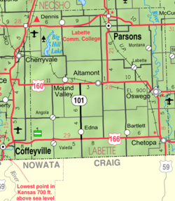
Dennis is a census-designated place (CDP) in Labette County, Kansas, United States. [1] As of the 2020 census, the population was 152. [2]
Dennis had its start in the early 1880s by the building of the Memphis, Kansas and Colorado Railroad through that territory. [3] The first post office in Dennis was established in May 1881. [4]
The nearby Big Hill Archeological District is on the National Register of Historic Places.
Census | Pop. | Note | %± |
---|---|---|---|
2020 | 152 | — | |
U.S. Decennial Census |
The community is served by Labette County USD 506 public school district.
Neosho County is a county located in Southeast Kansas. Its county seat is Erie. As of the 2020 census, the county population was 15,904. The county was named for the Neosho River, which passes through the county.
Labette County is a county located in Southeast Kansas. Its county seat is Oswego, and its most populous city is Parsons. As of the 2020 census, the county population was 20,184. The county was named after LaBette creek, the second-largest creek in the county, which runs roughly NNW-SSE from near Parsons to Chetopa. The creek in turn was named after French-Canadian fur trapper Pierre LaBette who had moved to the area, living along the Neosho River, and marrying into the Osage tribe in the 1830s and 1840s.
Crawford County is a county located in Southeast Kansas. Its county seat is Girard, and its most populous city is Pittsburg. As of the 2020 census, the county population was 38,972. The county was named in honor of Samuel Crawford, the 3rd governor of Kansas. Pittsburg State University is located in Crawford County.
Parsons is a city in Labette County, Kansas, United States. As of the 2020 census, the population of the city was 9,600. It is the most populous city of Labette County, and the second-most populous city in the southeastern region of Kansas. It is home to Labette Community College and the Parsons State Hospital & Training Center.
Mullica Hill is a census-designated place (CDP) and unincorporated community within Harrison Township in Gloucester County, in the U.S. state of New Jersey. As of the 2020 United States census, the CDP's population was 4,698, an increase of 716 (+18.0%) from the 3,982 counted at the 2010 U.S. census, which in turn reflected an increase of 2,324 (+140.2%) from the 1,658 enumerated at the 2000 census.
Riverton is a census-designated place (CDP) in Cherokee County, Kansas, United States. As of the 2020 census, the population was 771. It is located at the junction of K-66 and U.S. Route 69 Alternate and U.S. Route 400, near the Spring River. It is one of only three communities in Kansas along former U.S. Route 66.
Silverdale is a census-designated place (CDP) in Silverdale Township, Cowley County, Kansas, United States. As of the 2020 census, the population was 61.
Talmage is a census-designated place (CDP) in Dickinson County, Kansas, United States. As of the 2020 census, the population was 78.
Yoder is a census-designated place (CDP) in Reno County, Kansas, United States. As of the 2020 census, the population was 165. It is located approximately 10 miles southeast of the city of Hutchinson on K-96. Although Yoder is unincorporated, with no city government, it does have a U.S. Post Office and its own ZIP code (67585). Yoder is the hub of a local Amish community.
Johnsonburg is an unincorporated community and census-designated place (CDP) located within Frelinghuysen Township in Warren County, in the U.S. state of New Jersey, that was created as part of the 2010 United States Census. As of the 2020 Census, the CDP's population was 381, up from 101 in the 2010 Census.
Neshanic Station is an unincorporated community and census-designated place (CDP) located within Branchburg and extending into Hillsborough Township, Somerset County, in the U.S. state of New Jersey. In 2016 most of the village was listed on the National Register of Historic Places as the Neshanic Station Historic District.
Asherville is a census-designated place (CDP) in Mitchell County, Kansas, United States. As of the 2020 census, the population was 19.
Welda is a census-designated place (CDP) in Anderson County, Kansas, United States. As of the 2020 census, the population was 149.
Sycamore is a census-designated place (CDP) in northern Montgomery County, Kansas, United States. As of the 2020 census, the population was 70. It is located along U.S. Route 75 north of the city of Independence.
Vassar is a census-designated place (CDP) in Osage County, Kansas, United States. As of the 2020 census, the population was 584. It is located 4 miles (6.4 km) northeast of Lyndon, also about half a mile south of Pomona Lake.
Wakarusa is a census-designated place (CDP) in Shawnee County, Kansas, United States. As of the 2020 census, the population was 242. It is located 11 miles (18 km) south of downtown Topeka. Wakarusa is also the name of an unincorporated community in adjacent Douglas County, Kansas, 6.6 mi (10.6 km) southwest of downtown Lawrence and the name of the township that includes Lawrence, Kansas.
Rosalia is a census-designated place (CDP) in Butler County, Kansas, United States. As of the 2020 census, the population was 149. It is located approximately 12 miles (19 km) east of El Dorado.
Weskan is a census-designated place (CDP) in Wallace County, Kansas, United States. As of the 2020 census, the population was 158. It is located along U.S. Route 40, 11.5 miles (18.5 km) west-southwest of Sharon Springs. It is the closest community to Mount Sunflower, the highest point in Kanas.
Bala is a census-designated place (CDP) in Bala Township, Riley County, Kansas, United States. As of the 2020 census, the population was 29.
St. Benedict is a census-designated place (CDP) in Nemaha County, Kansas, United States. As of the 2020 census, the population was 50. It is located 3 miles north of the west edge of Seneca.