Valeda, Kansas | |
|---|---|
 | |
 Valeda  Valeda | |
| Coordinates: 37°02′50″N95°26′51″W / 37.04722°N 95.44750°W [1] | |
| Country | United States |
| State | Kansas |
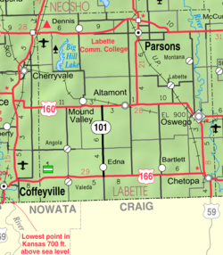
| County | Labette |
| Founded | 1880s |
| Platted | 1886 |
| Elevation | 860 ft (260 m) |
| Time zone | UTC-6 (CST) |
| • Summer (DST) | UTC-5 (CDT) |
| Area code | 620 |
| FIPS code | 20-72700 [1] |
| GNIS ID | 469169 [1] |
Valeda is an unincorporated community in Labette County, Kansas, United States. [1]
